Estimated Value: $250,000 - $292,000
3
Beds
2
Baths
1,908
Sq Ft
$145/Sq Ft
Est. Value
About This Home
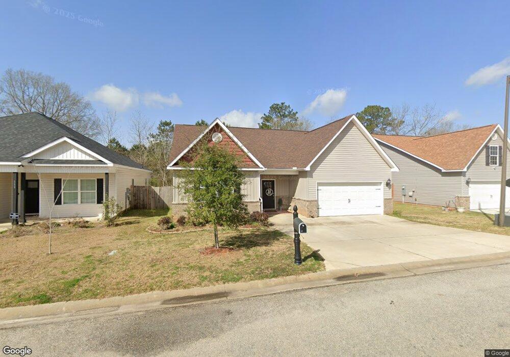
This home is located at 109 Sutton Dr, Perry, GA 31069 and is currently estimated at $277,182, approximately $145 per square foot. 109 Sutton Dr is a home located in Houston County with nearby schools including Langston Road Elementary School, Perry Middle School, and Perry High School.
Ownership History
Date
Name
Owned For
Owner Type
Purchase Details
Closed on
Dec 18, 2025
Sold by
La Loma Enterprises Inc
Bought by
Heyl Tara
Current Estimated Value
Purchase Details
Closed on
Apr 13, 2020
Sold by
Custom Homes By Dean Llc
Bought by
Harris Joel T and Harris Kimberly R
Home Financials for this Owner
Home Financials are based on the most recent Mortgage that was taken out on this home.
Original Mortgage
$182,900
Interest Rate
3.2%
Mortgage Type
New Conventional
Create a Home Valuation Report for This Property
The Home Valuation Report is an in-depth analysis detailing your home's value as well as a comparison with similar homes in the area
Home Values in the Area
Average Home Value in this Area
Purchase History
| Date | Buyer | Sale Price | Title Company |
|---|---|---|---|
| Heyl Tara | $249,900 | None Listed On Document | |
| Harris Joel T | $182,000 | None Available |
Source: Public Records
Mortgage History
| Date | Status | Borrower | Loan Amount |
|---|---|---|---|
| Previous Owner | Harris Joel T | $182,900 |
Source: Public Records
Tax History
| Year | Tax Paid | Tax Assessment Tax Assessment Total Assessment is a certain percentage of the fair market value that is determined by local assessors to be the total taxable value of land and additions on the property. | Land | Improvement |
|---|---|---|---|---|
| 2025 | $3,625 | $115,640 | $12,000 | $103,640 |
| 2024 | $3,968 | $109,240 | $12,000 | $97,240 |
| 2023 | $3,272 | $89,680 | $8,000 | $81,680 |
| 2022 | $1,760 | $78,560 | $8,000 | $70,560 |
| 2021 | $1,677 | $72,520 | $8,000 | $64,520 |
| 2020 | $840 | $36,160 | $8,000 | $28,160 |
| 2019 | $121 | $5,200 | $5,200 | $0 |
| 2018 | $121 | $5,200 | $5,200 | $0 |
| 2017 | $126 | $5,400 | $5,400 | $0 |
| 2016 | $126 | $5,400 | $5,400 | $0 |
| 2015 | $126 | $5,400 | $5,400 | $0 |
| 2014 | -- | $5,400 | $5,400 | $0 |
| 2013 | -- | $6,000 | $6,000 | $0 |
Source: Public Records
Map
Nearby Homes
- 204 Sutton Dr
- 206 Sutton Dr
- 119 Magnum Way
- 3004 Cellar Ln
- 210 Overton Dr
- 118 Bramblewood Way
- 111 Breakwater Way
- 0 Langston Rd Unit 16828609
- 0 Hwy 41 & Langston Rd Unit M170042
- 127 Bramblewood Ln
- 117 Bramblewood Ln
- 119 Bramblewood Ln
- 115 Bramblewood Ln
- 106 Raspberry Trail
- 101 Lighterknot Trail
- 206 Londe Ln
- 206 Londie Ln
- 209 Sugar Creek Trail
- 205 Sugar Creek Trail
- 207 Sugar Creek Trail
- 107 Sutton Dr
- 111 Sutton Dr
- 113 Sutton Dr
- 105 Sutton Dr
- 106 Sutton Dr
- 108 Sutton Dr
- 110 Sutton Dr
- 115 Sutton Dr
- 313 E River Cane Run
- 302 E River Cane Run
- 304 E River Cane Run
- 310 E River Cane Run
- 321 E River Cane Run Unit 17G
- 319 E River Cane Run
- 319 E River Cane Run Unit 16G
- 316 E River Cane Run Unit 28G
- 325 E River Cane Run Unit 19G
- 317 E River Cane Run Unit 15G
- 304 E River Cane Run Unit 82G
- 310 E River Cane Run Unit 31G
Your Personal Tour Guide
Ask me questions while you tour the home.