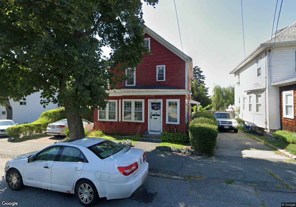
109 Verchild St Quincy, MA 02169
South Quincy NeighborhoodEstimated Value: $590,458 - $733,000
3
Beds
1
Bath
1,269
Sq Ft
$524/Sq Ft
Est. Value
About This Home
This home is located at 109 Verchild St, Quincy, MA 02169 and is currently estimated at $664,615, approximately $523 per square foot. 109 Verchild St is a home located in Norfolk County with nearby schools including Lincoln-Hancock Community School, South West Middle School, and Quincy High School.
Ownership History
Date
Name
Owned For
Owner Type
Purchase Details
Closed on
Feb 28, 1992
Sold by
Williams Ben H and Williams Margaret L
Bought by
Geraghty Robert M and Geraghty Susan M
Current Estimated Value
Home Financials for this Owner
Home Financials are based on the most recent Mortgage that was taken out on this home.
Original Mortgage
$92,625
Interest Rate
8.38%
Mortgage Type
Purchase Money Mortgage
Create a Home Valuation Report for This Property
The Home Valuation Report is an in-depth analysis detailing your home's value as well as a comparison with similar homes in the area
Home Values in the Area
Average Home Value in this Area
Purchase History
| Date | Buyer | Sale Price | Title Company |
|---|---|---|---|
| Geraghty Robert M | $123,500 | -- |
Source: Public Records
Mortgage History
| Date | Status | Borrower | Loan Amount |
|---|---|---|---|
| Open | Geraghty Robert M | $149,000 | |
| Closed | Geraghty Robert M | $125,000 | |
| Closed | Geraghty Robert M | $92,625 | |
| Closed | Geraghty Robert M | $24,700 |
Source: Public Records
Tax History Compared to Growth
Tax History
| Year | Tax Paid | Tax Assessment Tax Assessment Total Assessment is a certain percentage of the fair market value that is determined by local assessors to be the total taxable value of land and additions on the property. | Land | Improvement |
|---|---|---|---|---|
| 2025 | $5,700 | $494,400 | $239,400 | $255,000 |
| 2024 | $5,331 | $473,000 | $228,000 | $245,000 |
| 2023 | $4,886 | $439,000 | $207,300 | $231,700 |
| 2022 | $4,790 | $399,800 | $172,700 | $227,100 |
| 2021 | $4,549 | $374,700 | $172,700 | $202,000 |
| 2020 | $4,539 | $365,200 | $172,700 | $192,500 |
| 2019 | $4,415 | $351,800 | $162,900 | $188,900 |
| 2018 | $4,282 | $321,000 | $150,900 | $170,100 |
| 2017 | $4,264 | $300,900 | $143,700 | $157,200 |
| 2016 | $3,897 | $271,400 | $125,000 | $146,400 |
| 2015 | $3,736 | $255,900 | $125,000 | $130,900 |
| 2014 | $3,630 | $244,300 | $125,000 | $119,300 |
Source: Public Records
Map
Nearby Homes
- 195 Independence Ave Unit 137
- 218 Independence Ave Unit B
- 72 Federal Ave
- 10 Hughes St
- 52 Norman Rd
- 347 Centre St
- 21 Totman St Unit 204
- 21 Totman St Unit 202
- 21 Totman St Unit 309
- 21 Totman St Unit 306
- 21 Totman St Unit 410
- 21 Totman St Unit Model-1
- 21 Totman St Unit 2
- 83 Madison Ave
- 155 Kendrick Ave Unit T7
- 161 Cedar St
- 8 Jackson St Unit B2
- 94 Brook Rd Unit 3
- 102 Conrad St
- 166 Phipps St
- 107 Verchild St
- 152 Independence Ave
- 156 Independence Ave
- 156 Independence Ave Unit A
- 146 Independence Ave
- 103 Verchild St Unit 2
- 103 Verchild St
- 103-105 Verchild St
- 103 Verchild St Unit 2
- 105 Verchild St
- 105 Verchild St Unit 1
- 160 Independence Ave
- 158 Independence Ave
- 160 Independence Ave Unit B
- 110 Verchild St
- 138 Independence Ave
- 116 Verchild St
- 99 Verchild St
- 193 Federal Ave
- 179 Federal Ave