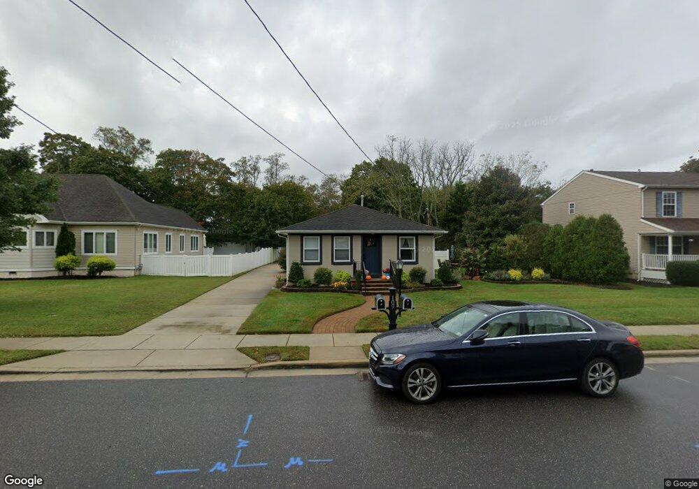
109 W Atlantic Ave Cape May Court House, NJ 08210
Estimated Value: $528,000 - $565,000
--
Bed
--
Bath
2,184
Sq Ft
$250/Sq Ft
Est. Value
About This Home
This home is located at 109 W Atlantic Ave, Cape May Court House, NJ 08210 and is currently estimated at $545,062, approximately $249 per square foot. 109 W Atlantic Ave is a home located in Cape May County with nearby schools including Middle Township Elementary No. 1, Middle Township Elementary No. 2, and Middle Township Middle School.
Ownership History
Date
Name
Owned For
Owner Type
Purchase Details
Closed on
Sep 27, 2023
Sold by
Sides Steve L and Sides Cori L
Bought by
Fyma90 Llc
Current Estimated Value
Purchase Details
Closed on
Feb 7, 2022
Sold by
Thomas Eric V and Thomas Stephanie A
Bought by
Sides Steve L and Sides Cori L
Purchase Details
Closed on
Nov 9, 2005
Sold by
James Callaway Dds Pa
Bought by
Zales Llc
Purchase Details
Closed on
Dec 1, 1995
Sold by
Callaway James
Bought by
Thomas Eric and Thomas Tracy Rose
Create a Home Valuation Report for This Property
The Home Valuation Report is an in-depth analysis detailing your home's value as well as a comparison with similar homes in the area
Home Values in the Area
Average Home Value in this Area
Purchase History
| Date | Buyer | Sale Price | Title Company |
|---|---|---|---|
| Fyma90 Llc | -- | Seaboard Title | |
| Fyma90 Llc | -- | Seaboard Title | |
| Sides Steve L | $344,000 | Seaboard Title | |
| Zales Llc | $285,000 | The Title Company Of Jersey | |
| Thomas Eric | $60,000 | -- |
Source: Public Records
Tax History Compared to Growth
Tax History
| Year | Tax Paid | Tax Assessment Tax Assessment Total Assessment is a certain percentage of the fair market value that is determined by local assessors to be the total taxable value of land and additions on the property. | Land | Improvement |
|---|---|---|---|---|
| 2025 | $8,278 | $392,500 | $126,400 | $266,100 |
| 2024 | $8,278 | $392,500 | $126,400 | $266,100 |
| 2023 | $7,264 | $353,300 | $126,400 | $226,900 |
| 2022 | $7,055 | $353,300 | $126,400 | $226,900 |
| 2021 | $6,886 | $353,300 | $126,400 | $226,900 |
| 2020 | $6,745 | $353,300 | $126,400 | $226,900 |
| 2019 | $6,571 | $353,300 | $126,400 | $226,900 |
| 2018 | $6,469 | $353,300 | $126,400 | $226,900 |
| 2017 | $6,338 | $353,300 | $126,400 | $226,900 |
| 2016 | $6,179 | $353,300 | $126,400 | $226,900 |
| 2015 | $6,133 | $353,300 | $126,400 | $226,900 |
| 2014 | $6,094 | $353,300 | $126,400 | $226,900 |
Source: Public Records
Map
Nearby Homes
- 310 Front St
- 215 S Boyd St
- 212 Shunpike Rd
- 220 Hand Ave
- 306 3rd St
- 105 E Atlantic Ave
- 144 Lee Ln Unit Front
- 5 Locust Ln
- 211 Colonial Ave
- 147 Lee Ln Unit 147
- 13 Poplar St
- 33 E Mechanic St
- 24 Church St
- 90 Wynndemere Ct
- 614 Route 9 S Unit 3
- 614 Route 9 S
- 104 Bay Breeze Blvd Unit 104
- 106 Bay Breeze Blvd Unit 106
- 26 Crest Rd
- 207 Bay Breeze Blvd Unit 9
- 111 W Atlantic Ave
- 107 W Atlantic Ave
- 113 W Atlantic Ave
- 101 W Atlantic Ave
- 108 W Atlantic Ave
- 308 Front St
- 115 W Atlantic Ave
- 403 S Boyd St
- 109 School House Ln
- 104 W Atlantic Ave
- 108 W Pacific Ave
- 405 S Boyd St
- 112 W Pacific Ave
- 312 Front St
- 103 W Atlantic Ave
- 112 W Atlantic Ave
- 106 W Pacific Ave
- 407 S Boyd St
- 102 W Atlantic Ave
- 27 W Atlantic Ave