--
Bed
--
Bath
3,991
Sq Ft
4,356
Sq Ft Lot
About This Home
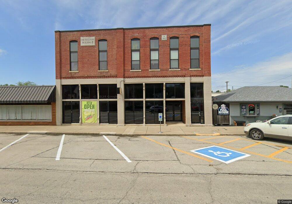
This home is located at 109 W Main St, Maroa, IL 61756. 109 W Main St is a home located in Macon County with nearby schools including Maroa-Forsyth Grade School, Maroa-Forsyth Middle School, and Maroa-Forsyth Senior High School.
Ownership History
Date
Name
Owned For
Owner Type
Purchase Details
Closed on
Dec 23, 2015
Sold by
Sullivan Reed W
Bought by
Isc Enterprises Inc
Purchase Details
Closed on
Nov 1, 2015
Purchase Details
Closed on
Jun 12, 2012
Sold by
Corrington Darrel and Miner Philip
Bought by
Sullivan Reed W
Home Financials for this Owner
Home Financials are based on the most recent Mortgage that was taken out on this home.
Original Mortgage
$215,000
Interest Rate
5.25%
Mortgage Type
Construction
Create a Home Valuation Report for This Property
The Home Valuation Report is an in-depth analysis detailing your home's value as well as a comparison with similar homes in the area
Home Values in the Area
Average Home Value in this Area
Purchase History
| Date | Buyer | Sale Price | Title Company |
|---|---|---|---|
| Isc Enterprises Inc | $140,000 | None Available | |
| -- | $280,000 | -- | |
| Sullivan Reed W | $30,000 | None Available |
Source: Public Records
Mortgage History
| Date | Status | Borrower | Loan Amount |
|---|---|---|---|
| Previous Owner | Sullivan Reed W | $215,000 |
Source: Public Records
Tax History Compared to Growth
Tax History
| Year | Tax Paid | Tax Assessment Tax Assessment Total Assessment is a certain percentage of the fair market value that is determined by local assessors to be the total taxable value of land and additions on the property. | Land | Improvement |
|---|---|---|---|---|
| 2024 | $2,996 | $32,813 | $3,688 | $29,125 |
| 2023 | $2,827 | $30,490 | $3,427 | $27,063 |
| 2022 | $2,679 | $28,760 | $3,232 | $25,528 |
| 2021 | $2,595 | $27,318 | $3,070 | $24,248 |
| 2020 | $2,164 | $23,426 | $2,893 | $20,533 |
| 2019 | $2,164 | $23,426 | $2,893 | $20,533 |
| 2018 | $2,069 | $22,870 | $2,824 | $20,046 |
| 2017 | $2,165 | $22,967 | $2,836 | $20,131 |
| 2016 | $2,160 | $22,940 | $2,833 | $20,107 |
| 2015 | $2,042 | $22,271 | $2,750 | $19,521 |
| 2014 | $1,992 | $22,051 | $2,723 | $19,328 |
| 2013 | $1,996 | $22,051 | $2,723 | $19,328 |
Source: Public Records
Map
Nearby Homes
- 212 W Main St
- 303 W Main St
- 309 N Linden St
- 14479 N Oakland Ave
- 3371 Hilltop Ct
- 6690 Little Galilee Rd
- 9150 N Route 51
- 6119 Little Galilee Rd
- 8349 Sawyer Rd
- 5434 Brittany Ln
- 7689 U S 51
- 164 Shadow Ridge Blvd
- 0 Betty Ln Unit 10514801
- 157 Shadow Ridge Blvd
- 120 Shadow Ridge Blvd
- 16 Holly Dr
- 335 Loma Dr
- 4789 Leghorn Rd
- 6080 Stagecoach Rd
- 31 Colonial Dr
- 109 W Main St Unit 3D
- 109 W Main St Unit 4E
- 107 N Walnut St
- 115 W Main St
- 116 W Main St
- 129 N Walnut St
- 111 S Walnut St
- 109 E Main St
- 124 N Walnut St
- 137 N Walnut St
- 110 S Walnut St
- 111 N Hickory St
- 101 N Wood St
- 121 S Walnut St
- 114 E Main St
- 132 N Wood St
- 114 S Walnut St
- 128 N Walnut St
- 109 N Wood St
- 219 W Main St