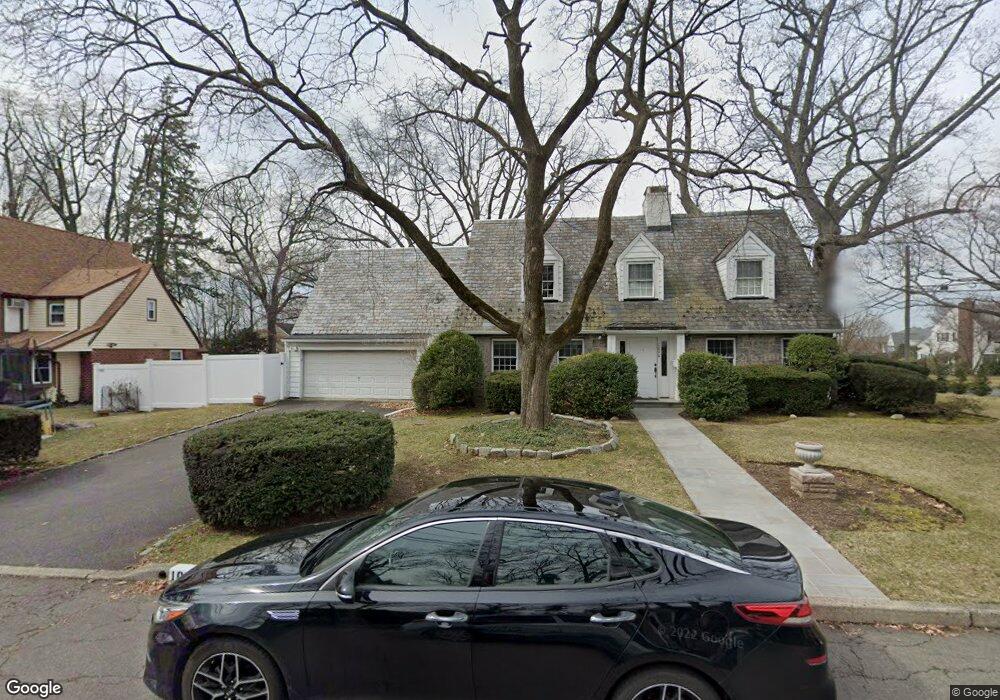
1090 Dartmouth St Teaneck, NJ 07666
Estimated Value: $805,000 - $1,026,000
--
Bed
--
Bath
2,849
Sq Ft
$335/Sq Ft
Est. Value
About This Home
This home is located at 1090 Dartmouth St, Teaneck, NJ 07666 and is currently estimated at $953,103, approximately $334 per square foot. 1090 Dartmouth St is a home located in Bergen County with nearby schools including Teaneck Senior High School, Teaneck Community Charter School, and Grace Lutheran School.
Ownership History
Date
Name
Owned For
Owner Type
Purchase Details
Closed on
Jun 14, 2018
Sold by
Musacchio Sergio E and Musacchio Michele L
Bought by
Dicolo Daniel G and Dicolo Kristina M
Current Estimated Value
Purchase Details
Closed on
Dec 21, 2017
Sold by
299 W Englewood Ave Llc
Bought by
Halpert Yehuda and Halpert Shoshana
Purchase Details
Closed on
Nov 24, 2004
Sold by
Lichtenstein Michael
Bought by
Halpert Yehuda and Halpert Shoshana
Home Financials for this Owner
Home Financials are based on the most recent Mortgage that was taken out on this home.
Original Mortgage
$416,800
Interest Rate
5.69%
Create a Home Valuation Report for This Property
The Home Valuation Report is an in-depth analysis detailing your home's value as well as a comparison with similar homes in the area
Home Values in the Area
Average Home Value in this Area
Purchase History
| Date | Buyer | Sale Price | Title Company |
|---|---|---|---|
| Dicolo Daniel G | $443,000 | -- | |
| Halpert Yehuda | -- | -- | |
| Halpert Yehuda | $521,000 | -- |
Source: Public Records
Mortgage History
| Date | Status | Borrower | Loan Amount |
|---|---|---|---|
| Previous Owner | Halpert Yehuda | $416,800 |
Source: Public Records
Tax History Compared to Growth
Tax History
| Year | Tax Paid | Tax Assessment Tax Assessment Total Assessment is a certain percentage of the fair market value that is determined by local assessors to be the total taxable value of land and additions on the property. | Land | Improvement |
|---|---|---|---|---|
| 2025 | $19,095 | $868,400 | $402,400 | $466,000 |
| 2024 | $17,874 | $874,300 | $402,400 | $471,900 |
| 2023 | $17,522 | $541,300 | $239,200 | $302,100 |
| 2022 | $17,522 | $541,300 | $239,200 | $302,100 |
| 2021 | $17,625 | $541,300 | $239,200 | $302,100 |
| 2020 | $17,506 | $541,300 | $239,200 | $302,100 |
| 2019 | $17,069 | $533,900 | $239,200 | $294,700 |
| 2018 | $16,941 | $533,900 | $239,200 | $294,700 |
| 2017 | $16,780 | $533,900 | $239,200 | $294,700 |
| 2016 | $16,530 | $533,900 | $239,200 | $294,700 |
| 2015 | $16,268 | $533,900 | $239,200 | $294,700 |
| 2014 | $15,233 | $592,500 | $343,700 | $248,800 |
Source: Public Records
Map
Nearby Homes
- 1106 Bromley Ave
- 665 Northumberland Rd
- 654 Suffern Rd
- 606 Standish Rd
- 565 N Forest Dr
- 543 Sagamore Ave
- 506 Sunderland Rd
- 700 Ramapo Rd
- 536 Sagamore Ave
- 710 Ramapo Rd
- 451 Sagamore Ave
- 995 Grace Terrace
- 1105 Belle Ave
- 711 Camperdown Rd
- 600 Martense Ave
- 364 Billington Rd
- 489 Maple Ave
- 425 Beatrice St
- 857 Garrison Ave
- 605 Beverly Rd
- 598 Northumberland Rd
- 1082 Dartmouth St
- 604 Northumberland Rd
- 1101 Dartmouth St
- 1074 Dartmouth St
- 1083 Pembroke St
- 1097 Pembroke St
- 593 Northumberland Rd
- 587 Northumberland Rd
- 1077 Pembroke St
- 1081 Dartmouth St
- 574 Northumberland Rd
- 581 Northumberland Rd
- 605 Northumberland Rd
- 1077 Dartmouth St
- 575 Northumberland Rd
- 1100 Cambridge Rd
- 566 Northumberland Rd
- 615 Northumberland Rd
- 1104 Cambridge Rd