Estimated Value: $554,742 - $584,000
5
Beds
2
Baths
1,180
Sq Ft
$484/Sq Ft
Est. Value
About This Home
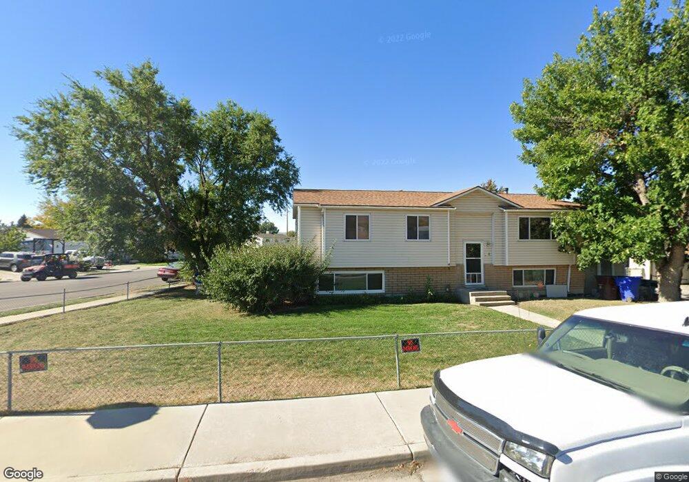
This home is located at 1090 W 1870 N, Lehi, UT 84043 and is currently estimated at $571,686, approximately $484 per square foot. 1090 W 1870 N is a home located in Utah County with nearby schools including Lehi Elementary School, Lehi Junior High School, and Lehi High School.
Ownership History
Date
Name
Owned For
Owner Type
Purchase Details
Closed on
Jul 25, 2025
Sold by
Johnson Family Trust and Johnson Chuck
Bought by
Campoverde Alex Valentino Vi and Tenecela Alex Segundo
Current Estimated Value
Home Financials for this Owner
Home Financials are based on the most recent Mortgage that was taken out on this home.
Original Mortgage
$564,585
Outstanding Balance
$563,621
Interest Rate
6.81%
Mortgage Type
FHA
Estimated Equity
$8,065
Purchase Details
Closed on
Sep 8, 2023
Sold by
Johnson Chuck
Bought by
Johnson Family Trust and Johnson
Home Financials for this Owner
Home Financials are based on the most recent Mortgage that was taken out on this home.
Original Mortgage
$463,600
Interest Rate
6.81%
Mortgage Type
New Conventional
Purchase Details
Closed on
Jan 10, 2023
Sold by
Bristol Kelly R and Bristol Kristie
Bought by
Bases Loaded Investing Llc
Home Financials for this Owner
Home Financials are based on the most recent Mortgage that was taken out on this home.
Original Mortgage
$400,000
Interest Rate
6.49%
Mortgage Type
New Conventional
Purchase Details
Closed on
Oct 25, 1996
Sold by
Bristol Kelly R
Bought by
Bristol Kelly R and Bristol Kristie
Home Financials for this Owner
Home Financials are based on the most recent Mortgage that was taken out on this home.
Original Mortgage
$79,000
Interest Rate
8.11%
Create a Home Valuation Report for This Property
The Home Valuation Report is an in-depth analysis detailing your home's value as well as a comparison with similar homes in the area
Home Values in the Area
Average Home Value in this Area
Purchase History
| Date | Buyer | Sale Price | Title Company |
|---|---|---|---|
| Campoverde Alex Valentino Vi | -- | Key Land Title | |
| Johnson Family Trust | -- | Key Land Title | |
| Johnson Chuck | -- | Alpine Legal Title | |
| Bases Loaded Investing Llc | -- | Alpine Legal Title | |
| Bristol Kelly R | -- | Metro National Title |
Source: Public Records
Mortgage History
| Date | Status | Borrower | Loan Amount |
|---|---|---|---|
| Open | Campoverde Alex Valentino Vi | $564,585 | |
| Previous Owner | Johnson Chuck | $463,600 | |
| Previous Owner | Bases Loaded Investing Llc | $400,000 | |
| Previous Owner | Bristol Kelly R | $79,000 |
Source: Public Records
Tax History Compared to Growth
Tax History
| Year | Tax Paid | Tax Assessment Tax Assessment Total Assessment is a certain percentage of the fair market value that is determined by local assessors to be the total taxable value of land and additions on the property. | Land | Improvement |
|---|---|---|---|---|
| 2025 | $1,954 | $242,935 | $176,800 | $264,900 |
| 2024 | $1,954 | $228,690 | $0 | $0 |
| 2023 | $1,783 | $226,545 | $0 | $0 |
| 2022 | $1,713 | $211,035 | $0 | $0 |
| 2021 | $1,512 | $281,600 | $102,300 | $179,300 |
| 2020 | $1,425 | $262,300 | $94,700 | $167,600 |
| 2019 | $1,371 | $262,300 | $94,700 | $167,600 |
| 2018 | $1,322 | $239,100 | $89,800 | $149,300 |
| 2017 | $1,255 | $120,725 | $0 | $0 |
| 2016 | $1,168 | $104,225 | $0 | $0 |
| 2015 | $1,216 | $103,015 | $0 | $0 |
| 2014 | $1,166 | $98,230 | $0 | $0 |
Source: Public Records
Map
Nearby Homes
- 1011 W Mountain Way Unit 316
- 1272 W 1800 N
- 1249 W 1800 N
- 1610 N 1125 W
- 1817 W Bad Rock Cir
- 1332 W 1500 N
- 902 W 1500 N
- 1094 W 1425 N
- 2287 N 750 W
- 5312 N Springview Ct Unit 106
- 1027 N 3685 W Unit 248
- 2191 W Swift Fox Dr Unit 274
- 999 Empire St
- 2184 W Cape Fox Way N Unit 220
- 1060 N Canvasback Dr Unit 405
- 1089 N 3685 W Unit 253
- 500 S Center St E
- 1077 N 3685 W Unit 252
- 1672 S 70 W
- 2209 W Swift Fox Way Unit 271
- 1267 W State St
- 1131 W State St
- 1096 W 1870 N
- 1089 W 1870 N
- 1095 W 1870 N
- 1163 W 1900 N
- 1102 W 1870 N
- 1014 W Mountain Way
- 1060 W State St
- 1040 W State St
- 1855 Trinnaman Ln
- 1024 W State St
- 1183 W 1900 N
- 1855 N Trinnaman Ln
- 1184 W 1870 N
- 1070 W 3100 N Unit 9
- 1008 W Spider Way Unit 303
- 1008 W Spider Way Unit 203
- 1857 N 1100 W
- 1000 W State St