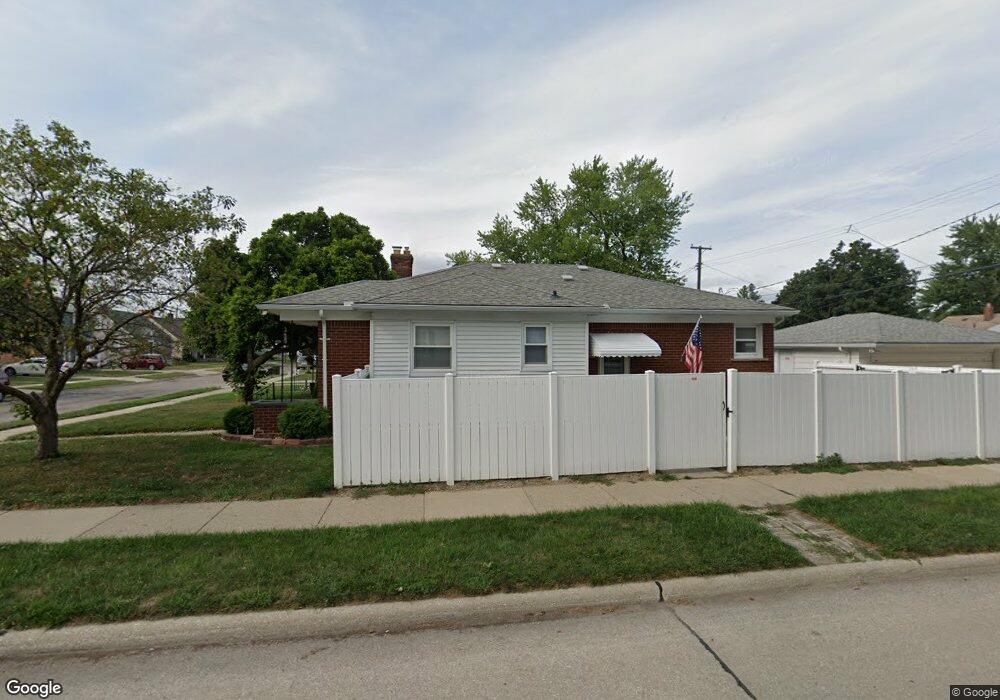
1091 23rd St Unit Bldg-Unit Wyandotte, MI 48192
Estimated Value: $198,000 - $239,000
--
Bed
1
Bath
1,310
Sq Ft
$163/Sq Ft
Est. Value
About This Home
This home is located at 1091 23rd St Unit Bldg-Unit, Wyandotte, MI 48192 and is currently estimated at $213,410, approximately $162 per square foot. 1091 23rd St Unit Bldg-Unit is a home located in Wayne County with nearby schools including Jefferson Elementary School, Woodrow Wilson School, and Roosevelt High School.
Ownership History
Date
Name
Owned For
Owner Type
Purchase Details
Closed on
Aug 14, 2018
Sold by
Carmel C Azzopardi Trust
Bought by
Epperson Beau C
Current Estimated Value
Home Financials for this Owner
Home Financials are based on the most recent Mortgage that was taken out on this home.
Original Mortgage
$107,908
Outstanding Balance
$95,886
Interest Rate
5.62%
Mortgage Type
FHA
Estimated Equity
$117,524
Purchase Details
Closed on
Dec 8, 2008
Sold by
Azzopardi Joseph and Estate Of Carmel C Azzopardi
Bought by
Carmel C Azzopardi Trust
Purchase Details
Closed on
Sep 19, 2005
Sold by
Clark Margaret G and Howard J Gerth Trust
Bought by
Azzopardi Carmel C
Purchase Details
Closed on
Aug 15, 2001
Sold by
Gerth Howard J and Gerth Marie E
Bought by
Gerth Howard J and Howard J Gerth Trust Agreement
Create a Home Valuation Report for This Property
The Home Valuation Report is an in-depth analysis detailing your home's value as well as a comparison with similar homes in the area
Home Values in the Area
Average Home Value in this Area
Purchase History
| Date | Buyer | Sale Price | Title Company |
|---|---|---|---|
| Epperson Beau C | $109,900 | Michigan Title Ins Agency In | |
| Carmel C Azzopardi Trust | -- | None Available | |
| Azzopardi Carmel C | -- | Multiple | |
| Gerth Howard J | -- | -- |
Source: Public Records
Mortgage History
| Date | Status | Borrower | Loan Amount |
|---|---|---|---|
| Open | Epperson Beau C | $107,908 |
Source: Public Records
Tax History Compared to Growth
Tax History
| Year | Tax Paid | Tax Assessment Tax Assessment Total Assessment is a certain percentage of the fair market value that is determined by local assessors to be the total taxable value of land and additions on the property. | Land | Improvement |
|---|---|---|---|---|
| 2025 | $3,147 | $101,900 | $0 | $0 |
| 2024 | $3,147 | $96,900 | $0 | $0 |
| 2023 | $3,002 | $87,600 | $0 | $0 |
| 2022 | $3,477 | $75,500 | $0 | $0 |
| 2021 | $3,407 | $72,600 | $0 | $0 |
| 2020 | $3,360 | $66,100 | $0 | $0 |
| 2019 | $3,314 | $60,400 | $0 | $0 |
| 2018 | $1,795 | $40,400 | $0 | $0 |
| 2017 | $1,246 | $40,400 | $0 | $0 |
| 2016 | $2,392 | $36,700 | $0 | $0 |
| 2015 | $3,221 | $34,100 | $0 | $0 |
| 2013 | $3,120 | $31,200 | $0 | $0 |
| 2012 | $1,819 | $32,700 | $6,800 | $25,900 |
Source: Public Records
Map
Nearby Homes
- 1125 Harrison Blvd
- 4194 Drouillard St
- 1919 Goddard St
- 1072 Harrison Blvd
- 12945 Brest St
- 1044 Cloverlawn Blvd
- 4118 Hubbard Ave
- 1136 18th St
- 4123 Lafayette Blvd
- 13105 Oakdale St
- 1645 22nd St
- 1679 23rd St
- 1439 18th St
- 1088 Ford Blvd
- 973 Ford Blvd
- 13357 Brest St
- 1482 16th St
- 13296 Rosedale St
- 1246 15th St
- 1505 Ford Blvd