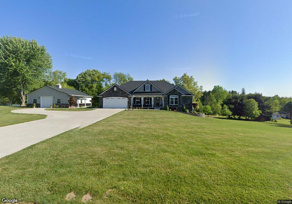
1091 Avalon Rd Mount Vernon, OH 43050
Estimated Value: $344,000 - $485,871
3
Beds
2
Baths
1,638
Sq Ft
$256/Sq Ft
Est. Value
About This Home
This home is located at 1091 Avalon Rd, Mount Vernon, OH 43050 and is currently estimated at $419,218, approximately $255 per square foot. 1091 Avalon Rd is a home with nearby schools including Mount Vernon High School, St. Vincent de Paul School, and Mount Vernon Sda Elementary School.
Ownership History
Date
Name
Owned For
Owner Type
Purchase Details
Closed on
Apr 9, 2020
Sold by
Meyer Philip J and Meyer Donna J
Bought by
Meyer Lt
Current Estimated Value
Purchase Details
Closed on
Mar 26, 2018
Sold by
Levenson Ft
Bought by
Meyer Phillip J and Meyer Donna J
Purchase Details
Closed on
Nov 8, 1999
Sold by
Levenson Albert A and Levenson An
Bought by
Levenson Albert A and Levenson An
Purchase Details
Closed on
Sep 8, 1989
Sold by
Hissong Calvin and Hissong Marjori
Bought by
Levenson Albert A and Levenson An
Create a Home Valuation Report for This Property
The Home Valuation Report is an in-depth analysis detailing your home's value as well as a comparison with similar homes in the area
Home Values in the Area
Average Home Value in this Area
Purchase History
| Date | Buyer | Sale Price | Title Company |
|---|---|---|---|
| Meyer Lt | -- | None Available | |
| Meyer Philip J | -- | None Available | |
| Meyer Phillip J | -- | -- | |
| Levenson Albert A | -- | -- | |
| Levenson Albert A | $7,500 | -- |
Source: Public Records
Tax History
| Year | Tax Paid | Tax Assessment Tax Assessment Total Assessment is a certain percentage of the fair market value that is determined by local assessors to be the total taxable value of land and additions on the property. | Land | Improvement |
|---|---|---|---|---|
| 2024 | $5,725 | $134,660 | $17,050 | $117,610 |
| 2023 | $5,847 | $134,660 | $17,050 | $117,610 |
| 2022 | $4,373 | $92,870 | $11,760 | $81,110 |
| 2021 | $4,373 | $92,870 | $11,760 | $81,110 |
| 2020 | $4,267 | $92,870 | $11,760 | $81,110 |
| 2019 | $3,547 | $71,580 | $11,470 | $60,110 |
| 2018 | $453 | $71,060 | $11,470 | $59,590 |
| 2017 | $446 | $9,010 | $9,010 | $0 |
| 2016 | $416 | $8,340 | $8,340 | $0 |
| 2015 | $417 | $8,340 | $8,340 | $0 |
| 2014 | -- | $8,340 | $8,340 | $0 |
| 2013 | $412 | $7,840 | $7,840 | $0 |
Source: Public Records
Map
Nearby Homes
- 1737 Vernonview Dr
- 19 Avalon Rd
- 6 Fairway Dr
- 23 Upland Terrace
- 28 Upland Terrace
- 26-30 Dogwood Terrace
- 114 Roanoke St
- 112 Roanoke St
- 13 Eastgate Dr
- 200 Eastwood Dr
- 332 Wooster Rd
- 0 Miami St
- 1 Hilltop Dr
- 17421 Coshocton Rd
- 612 N Clinton St
- 419 E Pleasant St
- 418 E Pleasant St
- 12627 Upper Gilchrist Rd
- 108 Ringold St
- 0 Indian Hills Rd
- 1129 Avalon Rd
- 1115 Avalon Rd
- 1045 Avalon Rd
- 1275 Vernonview Dr
- 1275 Vernonview Dr
- 1035 Avalon Rd
- 144 Avalon Rd
- 1325 Vernonview Dr
- 138 Avalon Rd
- 1125 Vernonview Dr
- 1729 Vernonview Dr
- 155 Avalon Rd
- 133 Avalon Rd
- 588 Wooster Rd
- 1385 Vernonview Dr
- 129 Avalon Rd
- 130 Avalon Rd
- 1405 Vernonview Dr
- 602 Wooster Rd
- 123 Avalon Rd
Your Personal Tour Guide
Ask me questions while you tour the home.