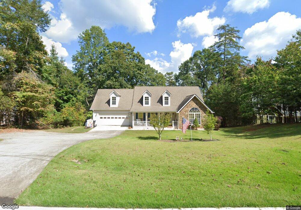
1091 Calhoun Rd Dahlonega, GA 30533
Estimated Value: $580,000 - $793,000
4
Beds
4
Baths
3,818
Sq Ft
$177/Sq Ft
Est. Value
About This Home
This home is located at 1091 Calhoun Rd, Dahlonega, GA 30533 and is currently estimated at $674,615, approximately $176 per square foot. 1091 Calhoun Rd is a home located in Lumpkin County with nearby schools including Clay County Middle School and Lumpkin County High School.
Ownership History
Date
Name
Owned For
Owner Type
Purchase Details
Closed on
Jun 11, 2004
Sold by
Pilcher Robert J
Bought by
Johnson Bruce A and Johnson Rosemary L
Current Estimated Value
Purchase Details
Closed on
Mar 2, 2004
Sold by
Hardman Bill T and Hardman Dorothy H
Bought by
Pilcher Robert J
Purchase Details
Closed on
Aug 23, 1996
Sold by
Ford Clyde N
Bought by
Pilcher Robert J
Purchase Details
Closed on
May 29, 1991
Sold by
Stowe Kenneth
Bought by
Gaston John T
Purchase Details
Closed on
Apr 1, 1974
Bought by
Stowe Kenneth
Create a Home Valuation Report for This Property
The Home Valuation Report is an in-depth analysis detailing your home's value as well as a comparison with similar homes in the area
Home Values in the Area
Average Home Value in this Area
Purchase History
| Date | Buyer | Sale Price | Title Company |
|---|---|---|---|
| Johnson Bruce A | $212,500 | -- | |
| Pilcher Robert J | -- | -- | |
| Ajf Construction Inc | $30,000 | -- | |
| Pilcher Robert J | $8,500 | -- | |
| Ford Clyde N | -- | -- | |
| Gaston John T | $4,500 | -- | |
| Stowe Kenneth | -- | -- |
Source: Public Records
Tax History Compared to Growth
Tax History
| Year | Tax Paid | Tax Assessment Tax Assessment Total Assessment is a certain percentage of the fair market value that is determined by local assessors to be the total taxable value of land and additions on the property. | Land | Improvement |
|---|---|---|---|---|
| 2024 | $4,300 | $188,418 | $16,000 | $172,418 |
| 2023 | $3,723 | $177,836 | $16,000 | $161,836 |
| 2022 | $3,854 | $157,689 | $16,000 | $141,689 |
| 2021 | $3,276 | $129,990 | $10,000 | $119,990 |
| 2020 | $3,299 | $127,067 | $10,000 | $117,067 |
| 2019 | $3,436 | $131,067 | $14,000 | $117,067 |
| 2018 | $3,228 | $115,785 | $14,000 | $101,785 |
| 2017 | $3,140 | $110,532 | $14,000 | $96,532 |
| 2016 | $3,023 | $103,088 | $14,000 | $89,088 |
| 2015 | $2,691 | $103,088 | $14,000 | $89,088 |
| 2014 | $2,691 | $104,078 | $14,000 | $90,078 |
| 2013 | -- | $105,067 | $14,000 | $91,067 |
Source: Public Records
Map
Nearby Homes
- 1170 Calhoun Rd
- 1415 Calhoun Rd
- 99 Madeline Anthony Road Lots 44 and 45
- 99 Madeline Anthony Rd
- 567 Crown Mountain Way
- 735 Calhoun Rd
- Lot 20 Crown Mountain Way
- 0 Crown Mountain Way Unit 7666031
- LOT 13 Crown Mountain Way
- Lot 28 Crown Mountain Way
- Lot 30 Crown Mountain Way
- 490 Golden Ave
- 0 Crown Mountain Unit 7682225
- 0 Crown Mountain Unit 10644759
- 934 Golden Ave
- 747 Golden Ave
- 0 Calhoun Rd Unit 7643314
- 0 Calhoun Rd Unit 10598012
- 00 Calhoun Rd
- 0 Alicia Ln
- 1061 Calhoun Rd
- 1135 Calhoun Rd
- 0 (LOT 15) Shamans Way
- 1089 Calhoun Rd
- 1100 Calhoun Rd
- 0 Calhoun (Lot 21) Rd Unit 7096290
- 1146 Calhoun Rd
- 0 Calhoun Lot 21 Rd Unit 10276472
- 0 Calhoun Ln Unit 24 7470288
- 0 Calhoun Ln Unit 34
- 00 Calhoun Ln
- 0 Calhoun Ln Unit 8047321
- 0 Calhoun Ln Unit 34 8211357
- 0 Calhoun Ln Unit 8315523
- 1044 Calhoun Rd
- 1005 Calhoun Rd
- 1170 Calhoun Rd Unit 36
- 34 Calhoun Ln
- 1425 Calhoun Ln
- 975 Calhoun Rd