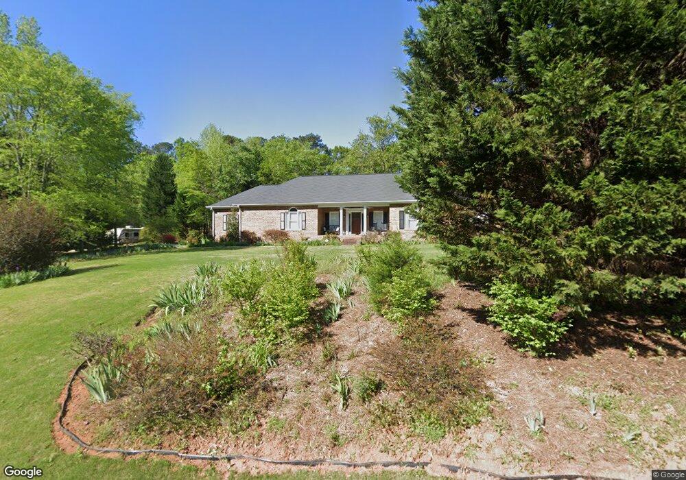
1091 Harrowford Dr N Statham, GA 30666
Estimated Value: $607,698 - $696,000
4
Beds
3
Baths
3,260
Sq Ft
$197/Sq Ft
Est. Value
About This Home
This home is located at 1091 Harrowford Dr N, Statham, GA 30666 and is currently estimated at $640,675, approximately $196 per square foot. 1091 Harrowford Dr N is a home located in Oconee County with nearby schools including Rocky Branch Elementary School, Malcom Bridge Middle School, and North Oconee High School.
Ownership History
Date
Name
Owned For
Owner Type
Purchase Details
Closed on
Jun 29, 2012
Sold by
Federal National Mortgage Association
Bought by
Cook Michael A and Cook Sara A
Current Estimated Value
Purchase Details
Closed on
Mar 6, 2012
Sold by
Jpmorgan Chase Bank Nation
Bought by
Federal National Mtg Associati
Purchase Details
Closed on
Mar 25, 2008
Sold by
Not Provided
Bought by
Cox James M and Crystal Ann Cox
Purchase Details
Closed on
Oct 4, 2002
Sold by
Atkinson Harry C
Bought by
Cox James M
Purchase Details
Closed on
Aug 31, 1995
Bought by
Atkinson Harry C
Purchase Details
Closed on
Mar 29, 1995
Bought by
Baker Leon
Create a Home Valuation Report for This Property
The Home Valuation Report is an in-depth analysis detailing your home's value as well as a comparison with similar homes in the area
Home Values in the Area
Average Home Value in this Area
Purchase History
| Date | Buyer | Sale Price | Title Company |
|---|---|---|---|
| Cook Michael A | $198,000 | -- | |
| Cook Michael A | $198,000 | -- | |
| Federal National Mtg Associati | -- | -- | |
| Jpmorgan Chase Bank National A | -- | -- | |
| Cox James M | -- | -- | |
| Cox James M | $214,400 | -- | |
| Atkinson Harry C | $161,900 | -- | |
| Baker Leon | $12,000 | -- |
Source: Public Records
Tax History Compared to Growth
Tax History
| Year | Tax Paid | Tax Assessment Tax Assessment Total Assessment is a certain percentage of the fair market value that is determined by local assessors to be the total taxable value of land and additions on the property. | Land | Improvement |
|---|---|---|---|---|
| 2024 | $3,391 | $181,779 | $30,000 | $151,779 |
| 2023 | $3,391 | $165,300 | $22,000 | $143,300 |
| 2022 | $3,120 | $145,945 | $22,000 | $123,945 |
| 2021 | $2,605 | $113,165 | $22,000 | $91,165 |
| 2020 | $2,169 | $94,171 | $18,000 | $76,171 |
| 2019 | $2,134 | $92,646 | $18,000 | $74,646 |
| 2018 | $2,118 | $90,068 | $18,000 | $72,068 |
| 2017 | $2,023 | $86,058 | $18,000 | $68,058 |
Source: Public Records
Map
Nearby Homes
- LOT 10 Sikes Rd
- LOT 9 Sikes Rd
- LOT 8 Sikes Rd
- LOT 7 Sikes Rd
- LOT 6 Sikes Rd
- LOT 5 Sikes Rd
- LOT 4 Sikes Rd
- LOT 3 Sikes Rd
- LOT 2 Sikes Rd
- LOT 1 Sikes Rd
- 1080 Ashland Dr
- 1471 Sikes Rd
- 1296 Club Estates Rd
- 2492 Rambling Rill Dr
- N/A Hog Mountain Rd
- 1901 Hog Mountain Rd
- 1921 Hog Mountain Rd
- 4611 Monroe Hwy - Hwy 78
- 4611 Monroe Hwy - Hwy 78 Unit PARCEL C
- 2986 Coralbell Dr
- 1091 Harrowford Rd N
- 1111 Harrowford Rd N
- 1071 Harrowford Rd N
- N Harrowford Dr N
- 1090 Harrowford Rd N
- 1061 Harrowford Dr N
- 1131 Harrowford Rd N
- 1020 Richards Ct
- 1061 Harrowford Rd N
- 1110 Harrowford Dr N
- 1110 Harrowford Rd N
- 1041 Harrowford Dr N
- 1041 Harrowford Rd N
- 1030 Harrowford Dr N
- 1141 Harrowford Rd N
- 1030 Harrowford Rd N
- 1141 Harrowford Dr N
- 1130 Harrowford Dr N
- 1130 Harrowford Rd N
- 1140 Harrowford Dr N