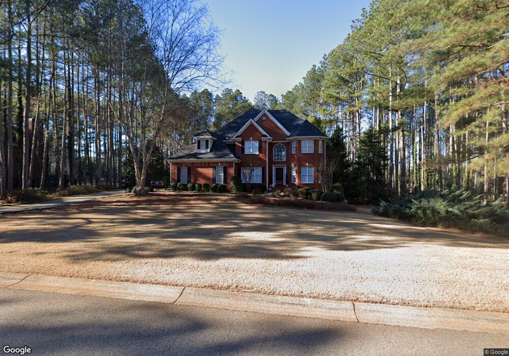
1091 Mallard Cir Bogart, GA 30622
Estimated Value: $678,000 - $808,000
--
Bed
--
Bath
3,292
Sq Ft
$220/Sq Ft
Est. Value
About This Home
This home is located at 1091 Mallard Cir, Bogart, GA 30622 and is currently estimated at $725,479, approximately $220 per square foot. 1091 Mallard Cir is a home located in Oconee County with nearby schools including Rocky Branch Elementary School, Malcom Bridge Middle School, and North Oconee High School.
Ownership History
Date
Name
Owned For
Owner Type
Purchase Details
Closed on
Apr 1, 2003
Sold by
Lowman Leah D
Bought by
Maddox Donald J
Current Estimated Value
Purchase Details
Closed on
Jun 25, 1999
Sold by
Slayton Wiley V
Bought by
Lowman Leah D
Purchase Details
Closed on
Oct 27, 1998
Sold by
Weirauch Charles E
Bought by
Slayton Wiley V
Create a Home Valuation Report for This Property
The Home Valuation Report is an in-depth analysis detailing your home's value as well as a comparison with similar homes in the area
Home Values in the Area
Average Home Value in this Area
Purchase History
| Date | Buyer | Sale Price | Title Company |
|---|---|---|---|
| Maddox Donald J | -- | -- | |
| Lowman Leah D | $288,900 | -- | |
| Slayton Wiley V | $29,900 | -- |
Source: Public Records
Tax History Compared to Growth
Tax History
| Year | Tax Paid | Tax Assessment Tax Assessment Total Assessment is a certain percentage of the fair market value that is determined by local assessors to be the total taxable value of land and additions on the property. | Land | Improvement |
|---|---|---|---|---|
| 2024 | $4,103 | $218,632 | $36,000 | $182,632 |
| 2023 | $4,077 | $201,700 | $32,000 | $169,700 |
| 2022 | $3,906 | $182,730 | $32,000 | $150,730 |
| 2021 | $3,873 | $168,057 | $30,000 | $138,057 |
| 2020 | $3,724 | $161,352 | $30,000 | $131,352 |
| 2019 | $3,607 | $156,323 | $30,000 | $126,323 |
| 2018 | $3,555 | $150,873 | $30,000 | $120,873 |
| 2017 | $3,541 | $150,256 | $30,000 | $120,256 |
| 2016 | $3,523 | $149,510 | $30,000 | $119,510 |
| 2015 | $3,232 | $136,940 | $28,000 | $108,940 |
| 2014 | $3,199 | $132,545 | $28,000 | $104,545 |
| 2013 | -- | $128,917 | $28,000 | $100,917 |
Source: Public Records
Map
Nearby Homes
- 1496 Malcom Estates Dr
- 1224 Malcom Estates Point Unit Lot 67
- 1491 Virgil Langford Rd
- 2165 Harperfield Dr
- 0 Clotfelter Rd Unit 1025303
- 1105 Harperfield Dr
- 1381 Mayfair Way
- 2082 Wade Dr
- 1895 Vintage Place
- 2163 Heather Ln
- 3065 Brookhaven Dr
- 0 Us 53 Hwy Unit 10376334
- 1010 Long Creek Dr
- 1479 Mcfall Ct
- 1021 Bedford Trail
- 1071 Oaklake Cir
- 1496 Malcom Estates
- 1081 Mallard Cir
- 1111 Mallard Cir
- 1090 Mallard Cir
- 1110 Mallard Cir
- 0 Mallard Cir Unit 7410286
- 0 Mallard Cir Unit 7125362
- 0 Mallard Cir Unit 3275729
- 0 Mallard Cir Unit 3226416
- 0 Mallard Cir Unit 8659406
- 0 Mallard Cir Unit 8629489
- 0 Mallard Cir Unit 8396406
- 0 Mallard Cir Unit 7640371
- 0 Mallard Cir Unit 8607681
- 0 Mallard Cir Unit 8115356
- 0 Mallard Cir
- 1070 Mallard Cir
- 1061 Mallard Cir
- 1131 Mallard Cir
- 1060 Mallard Cir
- 1130 Mallard Cir