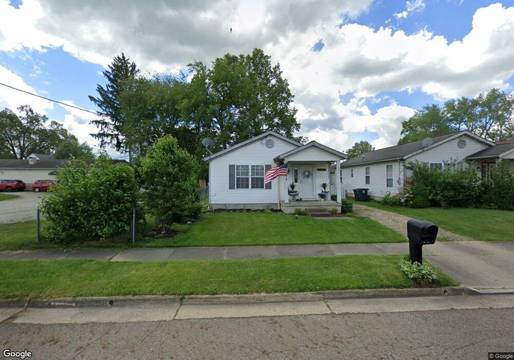
1092 Ivor Ave Akron, OH 44314
Kenmore NeighborhoodEstimated Value: $142,000 - $164,000
3
Beds
1
Bath
1,008
Sq Ft
$149/Sq Ft
Est. Value
About This Home
This home is located at 1092 Ivor Ave, Akron, OH 44314 and is currently estimated at $150,038, approximately $148 per square foot. 1092 Ivor Ave is a home located in Summit County with nearby schools including Kenmore Garfield Community Learning Center, Imagine Akron Academy, and Sam Salem Community Learning Center.
Ownership History
Date
Name
Owned For
Owner Type
Purchase Details
Closed on
Nov 8, 2000
Sold by
Monbeck William R and Monbeck Karen E
Bought by
Richmond Craig A and Richmond Delia M
Current Estimated Value
Home Financials for this Owner
Home Financials are based on the most recent Mortgage that was taken out on this home.
Original Mortgage
$83,000
Interest Rate
7.91%
Purchase Details
Closed on
Oct 26, 1999
Sold by
Stock Daniel G
Bought by
Monbeck William R and Monbeck Karen E
Purchase Details
Closed on
Mar 6, 1999
Sold by
Stock Daniel G
Bought by
Stock Daniel G
Create a Home Valuation Report for This Property
The Home Valuation Report is an in-depth analysis detailing your home's value as well as a comparison with similar homes in the area
Home Values in the Area
Average Home Value in this Area
Purchase History
| Date | Buyer | Sale Price | Title Company |
|---|---|---|---|
| Richmond Craig A | $83,000 | Buckeye Reserve Title Agency | |
| Monbeck William R | $7,666 | Buckeye Reserve Title Agency | |
| Stock Daniel G | -- | -- |
Source: Public Records
Mortgage History
| Date | Status | Borrower | Loan Amount |
|---|---|---|---|
| Closed | Richmond Craig A | $83,000 |
Source: Public Records
Tax History
| Year | Tax Paid | Tax Assessment Tax Assessment Total Assessment is a certain percentage of the fair market value that is determined by local assessors to be the total taxable value of land and additions on the property. | Land | Improvement |
|---|---|---|---|---|
| 2024 | $2,834 | $52,483 | $8,449 | $44,034 |
| 2023 | $2,834 | $52,483 | $8,449 | $44,034 |
| 2022 | $2,265 | $32,746 | $5,250 | $27,496 |
| 2021 | $2,267 | $32,746 | $5,250 | $27,496 |
| 2020 | $2,289 | $32,750 | $5,250 | $27,500 |
| 2019 | $2,421 | $31,570 | $5,030 | $26,540 |
| 2018 | $2,390 | $31,570 | $5,030 | $26,540 |
| 2017 | $2,372 | $31,570 | $5,030 | $26,540 |
| 2016 | $2,429 | $31,570 | $5,030 | $26,540 |
| 2015 | $2,372 | $31,570 | $5,030 | $26,540 |
| 2014 | $2,353 | $31,570 | $5,030 | $26,540 |
| 2013 | $2,303 | $31,550 | $5,030 | $26,520 |
Source: Public Records
Map
Nearby Homes
- 1144 Sutherland Ave
- 1203 Sarlson Ave
- 2912 Clearfield Ave
- 963 Winston St
- 1174 Kohler Ave
- 1288 Nestor Ave
- 1296 Weiser Ave
- 1147 Mcintosh Ave
- 1266 Kohler Ave
- 1178 Welsh Ave
- 835 Carnegie Ave
- 2967 Millbrook St
- 1237 Mcintosh Ave
- 1315 Kohler Ave
- 2465 28th St SW
- 1202 California Ave
- 2387 29th St SW Unit 2389
- 1207 California Ave
- 2354 21st St SW
- 1284 Kentucky Ave
- 1096 Ivor Ave
- 2769 Clearfield Ave
- 1091 Flanders Ave
- 1095 Flanders Ave
- 1087 Flanders Ave
- 1101 Flanders Ave
- 2766 Cory Ave
- 1079 Flanders Ave
- 2770 Clearfield Ave
- 2780 Cory Ave
- 1111 Flanders Ave
- 1118 Ivor Ave
- 1117 Flanders Ave
- 1096 Flanders Ave
- 1092 Flanders Ave
- 2765 Cory Ave
- 1086 Flanders Ave
- 1102 Flanders Ave
- 2773 Cory Ave
- 1080 Flanders Ave
Your Personal Tour Guide
Ask me questions while you tour the home.