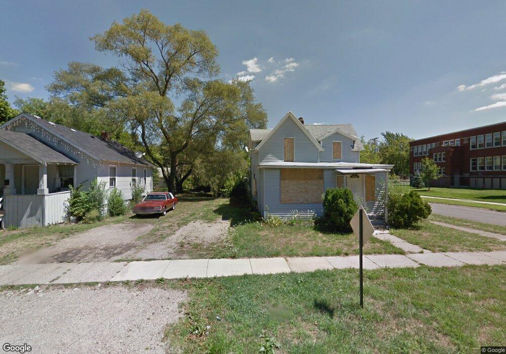
1093 Columbus Ave Benton Harbor, MI 49022
Estimated Value: $24,000 - $118,000
4
Beds
2
Baths
1,632
Sq Ft
$44/Sq Ft
Est. Value
About This Home
This home is located at 1093 Columbus Ave, Benton Harbor, MI 49022 and is currently estimated at $71,000, approximately $43 per square foot. 1093 Columbus Ave is a home located in Berrien County with nearby schools including Fair Plain Middle School, Benton Harbor High School, and Benton Harbor Charter School Academy.
Ownership History
Date
Name
Owned For
Owner Type
Purchase Details
Closed on
Dec 30, 2016
Sold by
Berrien County
Bought by
City Of Benton Harbor
Current Estimated Value
Purchase Details
Closed on
Nov 11, 2014
Sold by
Johnson Willie
Bought by
Burks John
Purchase Details
Closed on
Aug 22, 2013
Sold by
Pitchford Kimberly
Bought by
Johnson Willie
Purchase Details
Closed on
Mar 11, 2011
Sold by
Fannie Mae
Bought by
Pitchford Kimberly
Purchase Details
Closed on
Mar 18, 2010
Sold by
Graham Maurice and Graham Debra
Bought by
Federal National Mortgage Association
Purchase Details
Closed on
Sep 13, 1989
Purchase Details
Closed on
Sep 1, 1975
Create a Home Valuation Report for This Property
The Home Valuation Report is an in-depth analysis detailing your home's value as well as a comparison with similar homes in the area
Home Values in the Area
Average Home Value in this Area
Purchase History
| Date | Buyer | Sale Price | Title Company |
|---|---|---|---|
| City Of Benton Harbor | -- | Attorney | |
| Burks John | -- | None Available | |
| Johnson Willie | $500 | None Available | |
| Pitchford Kimberly | $6,300 | Attorneys Title Agency Llc | |
| Federal National Mortgage Association | $55,628 | None Available | |
| -- | $16,000 | -- | |
| -- | $12,000 | -- |
Source: Public Records
Tax History Compared to Growth
Tax History
| Year | Tax Paid | Tax Assessment Tax Assessment Total Assessment is a certain percentage of the fair market value that is determined by local assessors to be the total taxable value of land and additions on the property. | Land | Improvement |
|---|---|---|---|---|
| 2025 | -- | $0 | $0 | $0 |
| 2024 | -- | $0 | $0 | $0 |
| 2023 | -- | $0 | $0 | $0 |
| 2022 | $0 | $0 | $0 | $0 |
| 2021 | $0 | $0 | $0 | $0 |
| 2020 | $0 | $0 | $0 | $0 |
| 2019 | $1 | $0 | $0 | $0 |
| 2018 | $1 | $0 | $0 | $0 |
| 2017 | $0 | $0 | $0 | $0 |
| 2016 | $0 | $18,400 | $0 | $0 |
| 2015 | $1,105 | $17,700 | $0 | $0 |
| 2014 | $1,201 | $21,500 | $0 | $0 |
Source: Public Records
Map
Nearby Homes
- 361 E May St
- 1097 Pearl St
- 972 Pearl St
- 1219 Ogden Ave
- 349 E Empire Ave
- 1267 Broadway
- 1129 Jennings Ave
- 960 Jennings Ave
- 1142 Bishop Ave
- 1301 Superior St
- 833 Pearl St
- 1332 Columbus Ave
- 979 Lavette Ave
- 872 Mcalister Ave
- 960 Union Ave
- 171 E Empire Ave
- 1045 Broadway
- 941 Colfax Ave
- 1235 Colfax Ave
- 180 Emery Ave
- 1089 Columbus Ave
- 1081 Columbus Ave
- 423 E May St
- 1086 Columbus Ave
- 1078 Columbus Ave
- 1092 Superior St
- 1096 Columbus Ave
- 1061 Columbus Ave
- 1086 Superior St
- 1063 Columbus Ave
- 1070 Columbus Ave
- 1110 Columbus Ave
- 1076 Superior St
- 1070 Superior St
- 1118 Columbus Ave
- 1116 Columbus Ave
- 1131 Columbus Ave Unit 1115
- 1131 Columbus Ave
- 1060 Columbus Ave
- 1064 Superior St