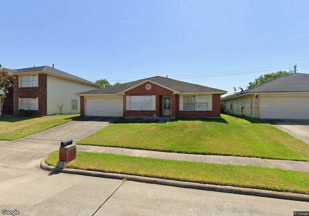
10947 Malden Dr Houston, TX 77075
Southbelt-Ellington NeighborhoodEstimated Value: $277,654 - $318,000
3
Beds
2
Baths
2,161
Sq Ft
$137/Sq Ft
Est. Value
About This Home
This home is located at 10947 Malden Dr, Houston, TX 77075 and is currently estimated at $295,414, approximately $136 per square foot. 10947 Malden Dr is a home located in Harris County with nearby schools including Atkinson Elementary School, Morris Middle School, and Beverly Hill Intermediate School.
Ownership History
Date
Name
Owned For
Owner Type
Purchase Details
Closed on
Apr 26, 2000
Sold by
Roanoke Building Company
Bought by
Alix Karen D
Current Estimated Value
Home Financials for this Owner
Home Financials are based on the most recent Mortgage that was taken out on this home.
Original Mortgage
$100,102
Outstanding Balance
$34,757
Interest Rate
8.21%
Mortgage Type
FHA
Estimated Equity
$260,657
Create a Home Valuation Report for This Property
The Home Valuation Report is an in-depth analysis detailing your home's value as well as a comparison with similar homes in the area
Home Values in the Area
Average Home Value in this Area
Purchase History
| Date | Buyer | Sale Price | Title Company |
|---|---|---|---|
| Alix Karen D | -- | Hold Commonwealth Title |
Source: Public Records
Mortgage History
| Date | Status | Borrower | Loan Amount |
|---|---|---|---|
| Open | Alix Karen D | $100,102 |
Source: Public Records
Tax History Compared to Growth
Tax History
| Year | Tax Paid | Tax Assessment Tax Assessment Total Assessment is a certain percentage of the fair market value that is determined by local assessors to be the total taxable value of land and additions on the property. | Land | Improvement |
|---|---|---|---|---|
| 2025 | $408 | $279,042 | $53,664 | $225,378 |
| 2024 | $408 | $274,899 | $53,664 | $221,235 |
| 2023 | $408 | $299,875 | $53,664 | $246,211 |
| 2022 | $5,657 | $250,546 | $41,184 | $209,362 |
| 2021 | $5,396 | $200,880 | $41,184 | $159,696 |
| 2020 | $5,301 | $193,401 | $37,440 | $155,961 |
| 2019 | $5,257 | $188,817 | $34,320 | $154,497 |
| 2018 | $60 | $165,773 | $26,520 | $139,253 |
| 2017 | $4,565 | $165,773 | $26,520 | $139,253 |
| 2016 | $4,264 | $154,841 | $24,024 | $130,817 |
| 2015 | $2,974 | $145,115 | $21,840 | $123,275 |
| 2014 | $2,974 | $135,336 | $21,840 | $113,496 |
Source: Public Records
Map
Nearby Homes
- 11019 Cayman Mist Dr
- 10918 Linden Gate Dr
- 10831 Cayman Mist Dr
- 10827 Linden Gate Dr
- 9423 Garden Bridge St
- 7329 Madison Commons Ln
- 7322 Madison Commons Ln
- 9303 Kingsflower Cir
- 10858 Shannon Mills Ln
- 9115 Kingsrose Ln
- 10847 Nellsfield Ln
- 0 Fuqua St Unit 64883593
- 0 Fuqua St Unit 45902141
- 0 Fuqua St Unit 97219329
- 9411 Kingsvalley St
- 9130 Garden Breeze Dr
- 9319 Canady Park Ln
- 9407 Kingspass St
- 10518 Tenleyton Ln
- 10906 Stover St
- 10943 Malden Dr
- 10951 Malden Dr
- 9682 Blackhawk Blvd
- 10939 Malden Dr
- 9686 Blackhawk Blvd
- 9678 Blackhawk Blvd
- 10946 Malden Dr
- 10950 Malden Dr
- 10942 Malden Dr
- 9674 Blackhawk Blvd
- 10935 Malden Dr
- 11003 Malden Dr
- 10938 Malden Dr
- 9702 Blackhawk Blvd
- 9670 Blackhawk Blvd
- 10934 Malden Dr
- 10931 Malden Dr
- 11002 Malden Dr
- 11007 Malden Dr
- 10947 Fern Terrace Dr