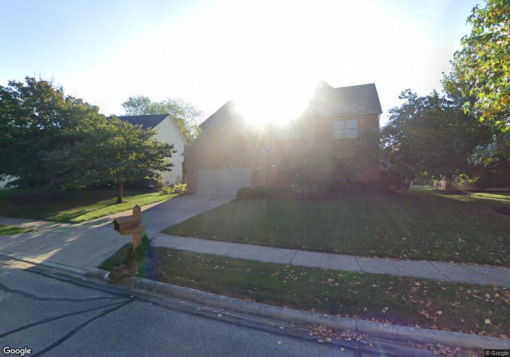
1096 Lake Point Westerville, OH 43082
Genoa NeighborhoodEstimated Value: $598,662 - $670,000
4
Beds
3
Baths
2,948
Sq Ft
$213/Sq Ft
Est. Value
About This Home
This home is located at 1096 Lake Point, Westerville, OH 43082 and is currently estimated at $628,416, approximately $213 per square foot. 1096 Lake Point is a home located in Delaware County with nearby schools including Robert Frost Elementary School, Heritage Middle School, and Westerville-North High School.
Ownership History
Date
Name
Owned For
Owner Type
Purchase Details
Closed on
Sep 8, 2003
Sold by
Buemi Charles S and Buemi Wendy A
Bought by
Buemi Charles S and Buemi Wendy A
Current Estimated Value
Purchase Details
Closed on
Feb 24, 1997
Sold by
J L Custom Homes Inc
Bought by
Buemi Charles S and Buemi Wendy A
Home Financials for this Owner
Home Financials are based on the most recent Mortgage that was taken out on this home.
Original Mortgage
$188,800
Outstanding Balance
$23,261
Interest Rate
7.92%
Mortgage Type
New Conventional
Estimated Equity
$605,155
Create a Home Valuation Report for This Property
The Home Valuation Report is an in-depth analysis detailing your home's value as well as a comparison with similar homes in the area
Home Values in the Area
Average Home Value in this Area
Purchase History
| Date | Buyer | Sale Price | Title Company |
|---|---|---|---|
| Buemi Charles S | -- | -- | |
| Buemi Charles S | $236,388 | -- |
Source: Public Records
Mortgage History
| Date | Status | Borrower | Loan Amount |
|---|---|---|---|
| Open | Buemi Charles S | $188,800 |
Source: Public Records
Tax History Compared to Growth
Tax History
| Year | Tax Paid | Tax Assessment Tax Assessment Total Assessment is a certain percentage of the fair market value that is determined by local assessors to be the total taxable value of land and additions on the property. | Land | Improvement |
|---|---|---|---|---|
| 2024 | $8,301 | $172,730 | $37,870 | $134,860 |
| 2023 | $8,238 | $172,730 | $37,870 | $134,860 |
| 2022 | $7,365 | $121,880 | $23,910 | $97,970 |
| 2021 | $7,428 | $121,880 | $23,910 | $97,970 |
| 2020 | $7,477 | $121,880 | $23,910 | $97,970 |
| 2019 | $6,793 | $106,930 | $23,910 | $83,020 |
| 2018 | $6,678 | $106,930 | $23,910 | $83,020 |
| 2017 | $3,424 | $105,220 | $20,970 | $84,250 |
| 2016 | $7,159 | $105,220 | $20,970 | $84,250 |
| 2015 | $6,848 | $105,220 | $20,970 | $84,250 |
| 2014 | $7,090 | $105,220 | $20,970 | $84,250 |
| 2013 | $6,686 | $101,960 | $20,970 | $80,990 |
Source: Public Records
Map
Nearby Homes
- 1155 Ashford Ct
- 7568 Park Bend Ct
- 6618 Wild Rose Ln
- 6685 Tussic Street Rd
- 974 Lakeland Dr
- 6460 Bromfield Dr
- 656 Olde Mill Dr
- 912 Lakeway Ct E
- 718 Sugar Ct
- 7663 Rolling Ridge Way
- 754 Kingsmead Rd Unit 18754
- 73 Keethler Dr S
- 9119 Robinhood Cir
- 6611 Lake of the Woods Point
- 8369 Manitou Dr
- 9200 Knoll Dr
- 7268 Clancy Way
- 7581 Lanetta Ln
- 6082 Hilmar Dr
- 90 Spring Creek Dr
- 1110 Lake Point Dr
- 1092 Lake Point
- 1110 Lake Point
- 1092 Lake Point Dr
- 1118 Lake Point
- 1095 Lake Point Dr
- 1088 Lake Point
- 1109 Lake Point Dr
- 1088 Lake Point Dr
- 1099 Lake Point Dr
- 1095 Lake Point
- 1103 Lake Point Dr
- 1145 Tidewater Ct
- 1091 Lake Point Dr
- 1103 Lake Point
- 1099 Lake Point
- 1143 Tidewater Ct
- 1091 Lake Point
- 1124 Lake Point
- 1109 Lake Point