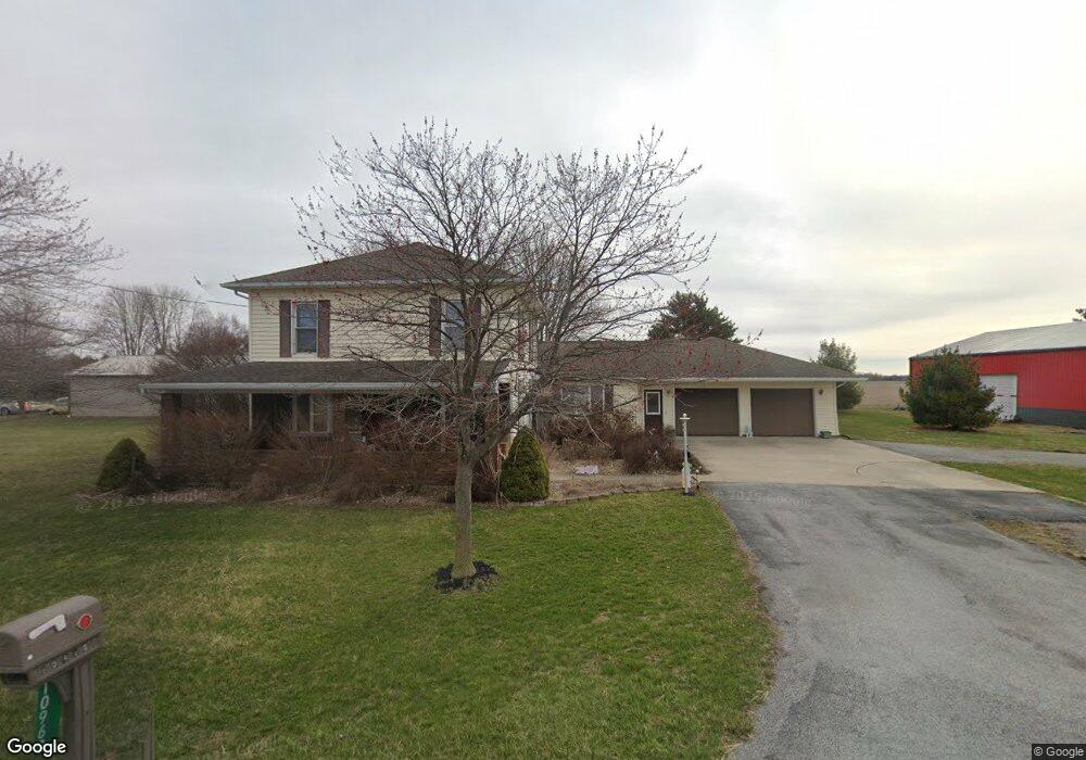
10960 Slabtown Rd Columbus Grove, OH 45830
Estimated Value: $286,053 - $387,000
6
Beds
2
Baths
2,552
Sq Ft
$124/Sq Ft
Est. Value
About This Home
This home is located at 10960 Slabtown Rd, Columbus Grove, OH 45830 and is currently estimated at $317,263, approximately $124 per square foot. 10960 Slabtown Rd is a home located in Allen County with nearby schools including Columbus Grove Elementary School, Columbus Grove Middle School, and Columbus Grove High School.
Ownership History
Date
Name
Owned For
Owner Type
Purchase Details
Closed on
Jan 30, 2007
Sold by
Dickman Gerald M and Dickman Constance H
Bought by
Morris John W and Morris Cathy J
Current Estimated Value
Home Financials for this Owner
Home Financials are based on the most recent Mortgage that was taken out on this home.
Original Mortgage
$145,000
Outstanding Balance
$17,225
Interest Rate
6.27%
Mortgage Type
Future Advance Clause Open End Mortgage
Estimated Equity
$300,038
Purchase Details
Closed on
Jun 1, 1978
Bought by
Dickman Gerald M
Create a Home Valuation Report for This Property
The Home Valuation Report is an in-depth analysis detailing your home's value as well as a comparison with similar homes in the area
Home Values in the Area
Average Home Value in this Area
Purchase History
| Date | Buyer | Sale Price | Title Company |
|---|---|---|---|
| Morris John W | $146,000 | None Available | |
| Dickman Gerald M | $36,500 | -- |
Source: Public Records
Mortgage History
| Date | Status | Borrower | Loan Amount |
|---|---|---|---|
| Open | Morris John W | $145,000 |
Source: Public Records
Tax History Compared to Growth
Tax History
| Year | Tax Paid | Tax Assessment Tax Assessment Total Assessment is a certain percentage of the fair market value that is determined by local assessors to be the total taxable value of land and additions on the property. | Land | Improvement |
|---|---|---|---|---|
| 2024 | $2,610 | $86,660 | $8,680 | $77,980 |
| 2023 | $2,322 | $71,020 | $7,110 | $63,910 |
| 2022 | $2,442 | $71,020 | $7,110 | $63,910 |
| 2021 | $2,467 | $71,020 | $7,110 | $63,910 |
| 2020 | $1,929 | $55,800 | $6,480 | $49,320 |
| 2019 | $1,929 | $55,800 | $6,480 | $49,320 |
| 2018 | $1,881 | $55,800 | $6,480 | $49,320 |
| 2017 | $1,817 | $51,320 | $6,480 | $44,840 |
| 2016 | $1,758 | $49,640 | $6,480 | $43,160 |
| 2015 | $1,679 | $49,640 | $6,480 | $43,160 |
| 2014 | $1,679 | $46,660 | $6,480 | $40,180 |
| 2013 | $1,638 | $46,660 | $6,480 | $40,180 |
Source: Public Records
Map
Nearby Homes
- 11059 Ottawa Rd
- 308 Delphos Rd
- 204 S Broadway St
- 205 S Broadway St
- 209 Willow Bend Dr
- 00000 Ohio 696
- 000 Ohio 696
- 0000 Ohio 696
- 6585 Ottawa Rd
- 201 Wall St
- 309 Wall St
- 147 Elm St
- 220 Parklane Dr
- 300 Sweaney Ave
- 8160 Columbus Grove-Bluffton Rd
- 148 S Water St
- 17429 Road 5
- 7957 Hillville Rd
- 704 Sherman St
- 6601 N Napoleon Rd