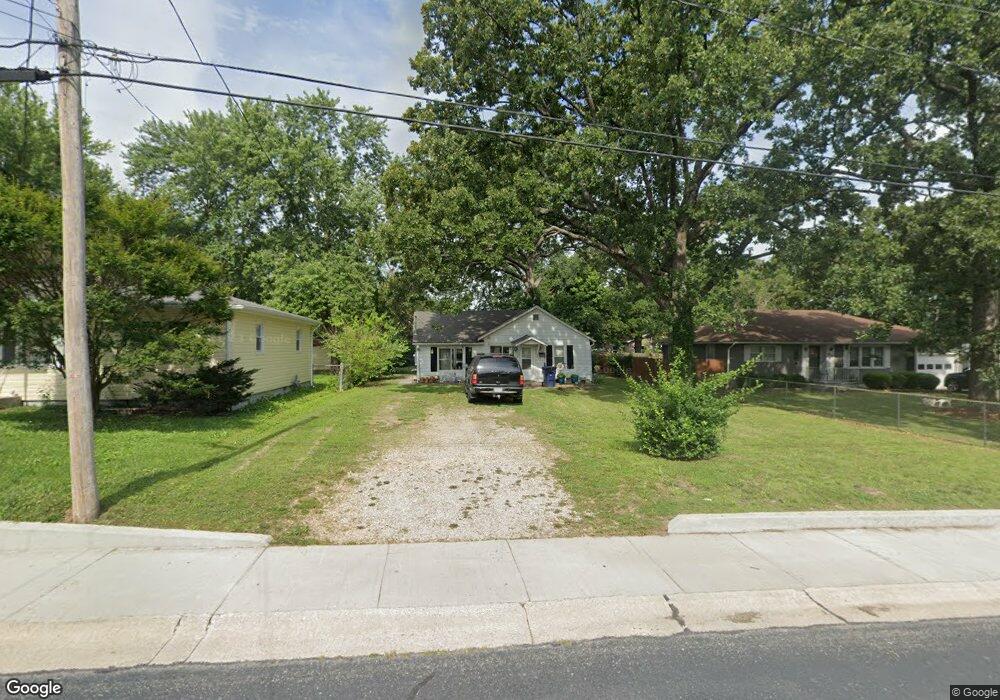
1097 N Adams Ave Lebanon, MO 65536
Estimated Value: $77,380 - $124,000
2
Beds
--
Bath
786
Sq Ft
$121/Sq Ft
Est. Value
About This Home
This home is located at 1097 N Adams Ave, Lebanon, MO 65536 and is currently estimated at $94,845, approximately $120 per square foot. 1097 N Adams Ave is a home located in Laclede County with nearby schools including Joe D. Esther Elementary School, Boswell Elementary School, and Maplecrest Elementary School.
Ownership History
Date
Name
Owned For
Owner Type
Purchase Details
Closed on
Feb 6, 2015
Sold by
Mcculloch Dennis
Bought by
Alva Ray Starnes & Sonja Dean Starnes Tr
Current Estimated Value
Home Financials for this Owner
Home Financials are based on the most recent Mortgage that was taken out on this home.
Original Mortgage
$28,125
Outstanding Balance
$21,645
Interest Rate
3.89%
Mortgage Type
Future Advance Clause Open End Mortgage
Estimated Equity
$73,200
Purchase Details
Closed on
Sep 7, 2010
Sold by
Light Katherine Marie
Bought by
Light E Kim and Light Katherine M
Create a Home Valuation Report for This Property
The Home Valuation Report is an in-depth analysis detailing your home's value as well as a comparison with similar homes in the area
Home Values in the Area
Average Home Value in this Area
Purchase History
| Date | Buyer | Sale Price | Title Company |
|---|---|---|---|
| Alva Ray Starnes & Sonja Dean Starnes Tr | -- | Hogan | |
| Light E Kim | -- | None Available |
Source: Public Records
Mortgage History
| Date | Status | Borrower | Loan Amount |
|---|---|---|---|
| Open | Alva Ray Starnes & Sonja Dean Starnes Tr | $28,125 |
Source: Public Records
Tax History Compared to Growth
Tax History
| Year | Tax Paid | Tax Assessment Tax Assessment Total Assessment is a certain percentage of the fair market value that is determined by local assessors to be the total taxable value of land and additions on the property. | Land | Improvement |
|---|---|---|---|---|
| 2025 | $267 | $5,260 | $0 | $0 |
| 2024 | $267 | $4,690 | $0 | $0 |
| 2023 | $276 | $4,690 | $0 | $0 |
| 2022 | $257 | $4,690 | $0 | $0 |
| 2021 | $283 | $4,693 | $1,330 | $3,363 |
| 2020 | $284 | $4,693 | $1,330 | $3,363 |
| 2019 | $272 | $4,690 | $1,330 | $3,360 |
| 2018 | $269 | $4,940 | $1,330 | $3,610 |
| 2017 | $255 | $4,940 | $0 | $0 |
| 2016 | $255 | $4,940 | $0 | $0 |
| 2015 | $255 | $4,940 | $0 | $0 |
| 2014 | $255 | $4,940 | $0 | $0 |
| 2013 | -- | $4,940 | $0 | $0 |
Source: Public Records
Map
Nearby Homes
- 282 Brice St
- 116 Smith Rd
- 791 N Adams Ave
- 466 Lynn St
- 009 Missouri 64
- 000 Missouri 64 Unit Lot 18
- 000 Missouri 64
- 000 Missouri 64 Unit Lot 16
- 002 Missouri 64
- 005 Missouri 64
- 000 Missouri 64 Unit Lot 14
- 003 Missouri 64
- 000 Missouri 64 Unit Lot 11
- 000 Missouri 64 Unit 17-19
- 012 Missouri 64
- 013 Missouri 64
- 000 Missouri 64 Unit Lot 19
- 007 Missouri 64
- 000 Missouri 64 Unit Lot 17
- 011 Missouri 64
- 1093 N Adams Ave
- 1089 N Adams Ave
- 1101 N Adams Ave
- 1062 N Adams Ave
- 1083 N Adams Ave
- 1083 N Adams Ave
- 1068 N Adams Ave
- 1100 N Adams Ave
- 1119 N Adams Ave
- 1005 N Adams Ave
- 1012 N Adams Ave
- 1174 N Adams Ave
- 694 Bennett St
- 680 Bennett St
- 1180 N Adams Ave
- 638 Bennett St
- 720 Bennett St
- 1006 N Adams Ave
- 632 Bennett St
- 310 Brice St