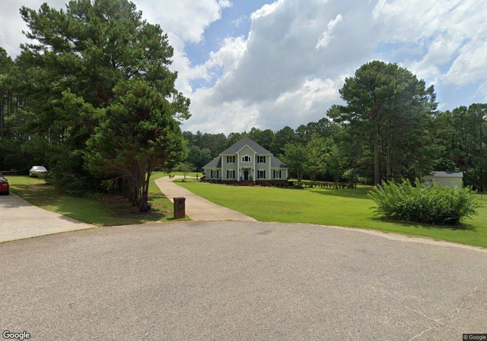
10976 Byron Ct E Semmes, AL 36575
Outer Semmes NeighborhoodEstimated Value: $365,000 - $530,000
4
Beds
4
Baths
3,480
Sq Ft
$127/Sq Ft
Est. Value
About This Home
This home is located at 10976 Byron Ct E, Semmes, AL 36575 and is currently estimated at $441,412, approximately $126 per square foot. 10976 Byron Ct E is a home located in Mobile County with nearby schools including Allentown Elementary School, Semmes Middle School, and Mary G Montgomery High School.
Ownership History
Date
Name
Owned For
Owner Type
Purchase Details
Closed on
Jul 9, 2001
Sold by
Crow Margaret I and Kamphuis Betty Pruitt
Bought by
Murphy Gregory M and Murphy Michelle P
Current Estimated Value
Home Financials for this Owner
Home Financials are based on the most recent Mortgage that was taken out on this home.
Original Mortgage
$28,000
Outstanding Balance
$10,483
Interest Rate
7.23%
Estimated Equity
$430,929
Create a Home Valuation Report for This Property
The Home Valuation Report is an in-depth analysis detailing your home's value as well as a comparison with similar homes in the area
Home Values in the Area
Average Home Value in this Area
Purchase History
| Date | Buyer | Sale Price | Title Company |
|---|---|---|---|
| Murphy Gregory M | -- | -- |
Source: Public Records
Mortgage History
| Date | Status | Borrower | Loan Amount |
|---|---|---|---|
| Open | Murphy Gregory M | $28,000 |
Source: Public Records
Tax History
| Year | Tax Paid | Tax Assessment Tax Assessment Total Assessment is a certain percentage of the fair market value that is determined by local assessors to be the total taxable value of land and additions on the property. | Land | Improvement |
|---|---|---|---|---|
| 2025 | $1,623 | $34,820 | $5,250 | $29,570 |
| 2024 | $1,623 | $33,330 | $4,500 | $28,830 |
| 2023 | $1,550 | $33,460 | $3,850 | $29,610 |
| 2022 | $1,441 | $31,100 | $6,480 | $24,620 |
| 2021 | $1,437 | $31,000 | $6,480 | $24,520 |
| 2020 | $1,477 | $31,820 | $6,930 | $24,890 |
| 2019 | $1,437 | $31,020 | $0 | $0 |
| 2018 | $1,450 | $31,280 | $0 | $0 |
| 2017 | $1,440 | $31,080 | $0 | $0 |
| 2016 | $1,450 | $31,280 | $0 | $0 |
| 2013 | $1,465 | $31,320 | $0 | $0 |
Source: Public Records
Map
Nearby Homes
- 3240 Normandy Dr E
- 11045 Wulff Rd S
- 10375 Wulff Rd S
- 0 Buck Ct Unit 7689573
- 0 Buck Ct Unit 18
- 10703 S Ridge Dr
- 10201 Broughton Rd
- 2071 Noah Ct
- 4295 Linbar Ln W
- 9885 Westward Dr
- 0 Snow Rd N Unit 7686288
- 0 Snow Rd N Unit 7686230
- 0 Snow Rd N Unit 7686272
- 1965 Whip Poor Will Ct S
- 9823 Torrington Dr N
- 3810 Torrington Dr E
- 9853 Winchester Dr S
- 9736 Sky Vista Dr
- 9500 Howells Ferry Rd
- 2950 Nic Lib Ln
- 11016 Byron Ct E
- 10975 Byron Ct E
- 11015 Byron Ct E
- 11046 Byron Ct E
- 11045 Byron Ct E Unit PVT
- 11066 Byron Ct E
- 11065 Byron Ct E
- 11026 Howells Ferry Rd
- 11030 Howells Ferry Rd
- 11040 Howells Ferry Rd
- 11020 Howells Ferry Rd
- 11086 Byron Ct W
- 2860 Carrie Trace
- 11087 Byron Ct W Unit 15
- 11087 Byron Ct W
- 3120 Wulff Rd
- 11034 Howells Ferry Rd
- 11034 Howells Ferry Rd Unit B
- 11096 Byron Ct W
- 11140 Howells Ferry Rd