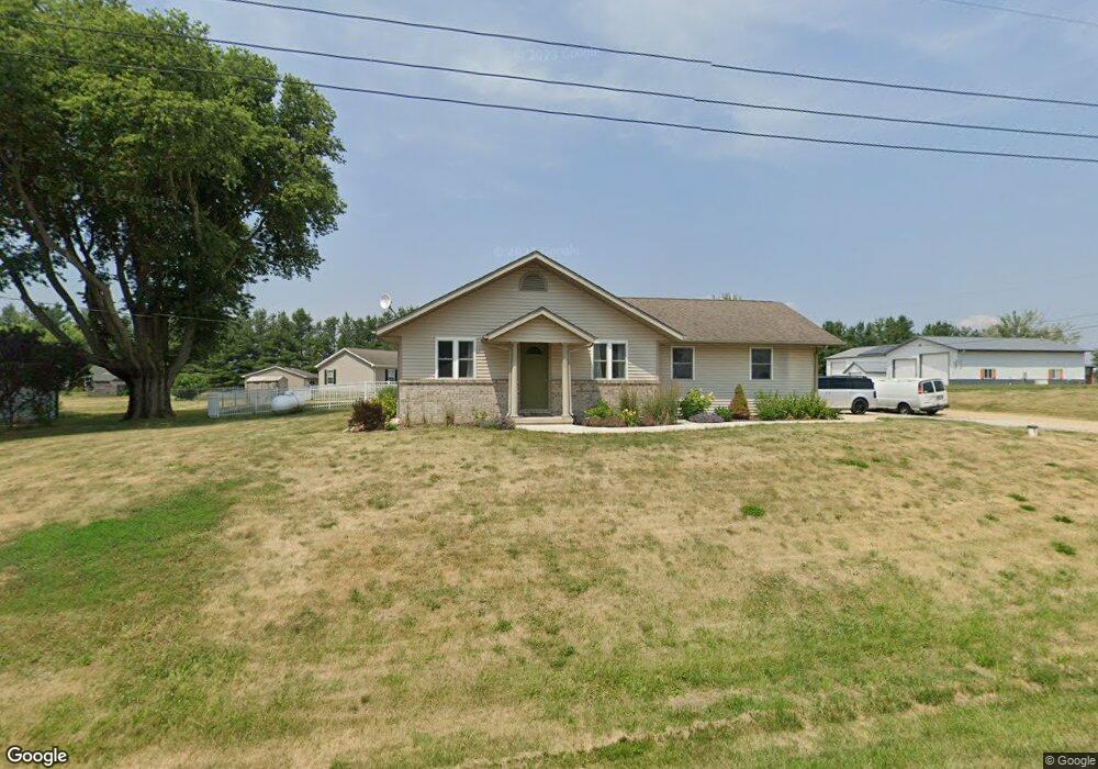
10977 Springfield Rd Tremont, IL 61568
Estimated Value: $136,000 - $238,000
3
Beds
2
Baths
1,196
Sq Ft
$160/Sq Ft
Est. Value
About This Home
This home is located at 10977 Springfield Rd, Tremont, IL 61568 and is currently estimated at $191,661, approximately $160 per square foot. 10977 Springfield Rd is a home located in Tazewell County with nearby schools including Tremont Elementary School, Tremont Middle School, and Tremont High School.
Ownership History
Date
Name
Owned For
Owner Type
Purchase Details
Closed on
Apr 27, 2007
Sold by
Quality Builders Of Central Illinois
Bought by
Lacey Ashley D
Current Estimated Value
Home Financials for this Owner
Home Financials are based on the most recent Mortgage that was taken out on this home.
Original Mortgage
$84,000
Outstanding Balance
$51,122
Interest Rate
6.18%
Mortgage Type
Purchase Money Mortgage
Estimated Equity
$140,539
Create a Home Valuation Report for This Property
The Home Valuation Report is an in-depth analysis detailing your home's value as well as a comparison with similar homes in the area
Home Values in the Area
Average Home Value in this Area
Purchase History
| Date | Buyer | Sale Price | Title Company |
|---|---|---|---|
| Lacey Ashley D | $142,500 | None Available |
Source: Public Records
Mortgage History
| Date | Status | Borrower | Loan Amount |
|---|---|---|---|
| Open | Lacey Ashley D | $84,000 |
Source: Public Records
Tax History Compared to Growth
Tax History
| Year | Tax Paid | Tax Assessment Tax Assessment Total Assessment is a certain percentage of the fair market value that is determined by local assessors to be the total taxable value of land and additions on the property. | Land | Improvement |
|---|---|---|---|---|
| 2024 | $2,933 | $50,500 | $7,790 | $42,710 |
| 2023 | $2,933 | $45,880 | $7,080 | $38,800 |
| 2022 | $2,739 | $41,670 | $6,430 | $35,240 |
| 2021 | $2,635 | $40,060 | $6,180 | $33,880 |
| 2020 | $2,655 | $40,060 | $6,180 | $33,880 |
| 2019 | $2,655 | $40,060 | $6,180 | $33,880 |
| 2018 | $2,622 | $40,060 | $6,180 | $33,880 |
| 2017 | $2,575 | $39,660 | $6,120 | $33,540 |
| 2016 | $2,537 | $39,660 | $6,120 | $33,540 |
| 2015 | $2,474 | $0 | $0 | $0 |
| 2013 | $2,443 | $39,270 | $6,060 | $33,210 |
Source: Public Records
Map
Nearby Homes
- 17902 Red Shale Hill Rd
- 7711 Linden Ln
- 3858 Sunset Dr
- 10109 Arrow Rd
- 7266 Granada Dr
- 313 W South St
- 1920-1922 Mayflower Dr
- 1960-1962 Mayflower Dr
- 105 Royal Point Ct
- 107 Lost Creek Ct
- 116 Lost Creek Ct
- 13694 Egg Ranch Rd
- 0 Illinois 9
- 316 N Locust St
- 0 Furrow Rd
- 1922 Highwood Ave
- 205 2nd St
- 309 First
- 16810 Springfield Rd
- 1824 Valencia Place
- 20451 Evergreen Ln
- 10699 Springfield Rd
- 20521 Townline Rd
- 10676 Springfield Rd
- 10741 Dillon Rd
- 10723 Springfield Rd
- 20577 Townline Rd
- 10689 Apple St
- 20534 Townline Rd
- 10736 Dillon Rd
- 20540 Peach St
- 10603 Springfield Rd
- 10626 Springfield Rd
- 20623 Townline Rd
- 10694 Apple St
- 11020 Springfield Rd
- 10664 Apple St
- 10664 Apple St
- 10596 Springfield Rd
- 10581 Springfield Rd