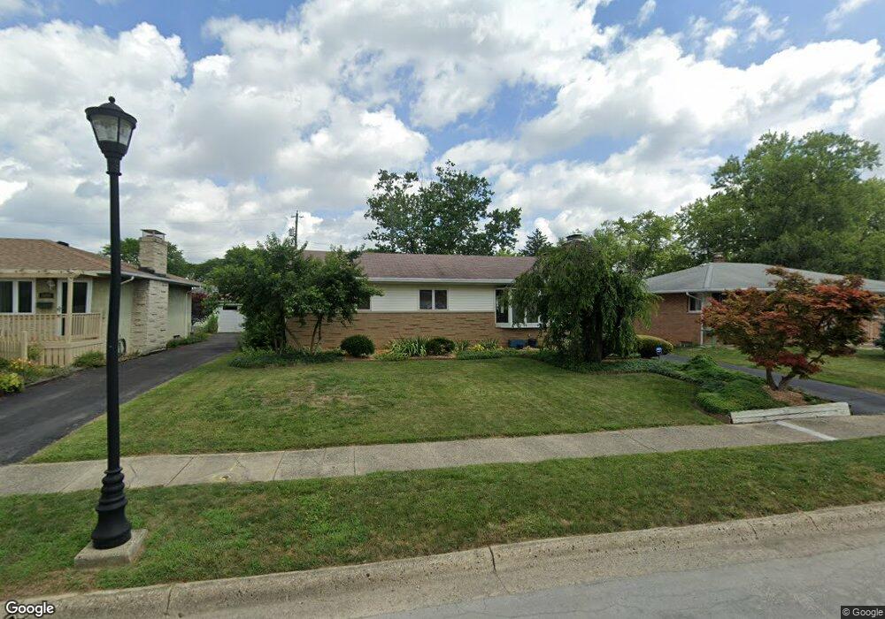
1098 Fordham Rd Columbus, OH 43224
Maize-Morse NeighborhoodEstimated Value: $282,941 - $331,000
3
Beds
2
Baths
1,460
Sq Ft
$205/Sq Ft
Est. Value
About This Home
This home is located at 1098 Fordham Rd, Columbus, OH 43224 and is currently estimated at $299,985, approximately $205 per square foot. 1098 Fordham Rd is a home located in Franklin County with nearby schools including Maize Road Elementary School, Medina Middle School, and Mifflin High School.
Ownership History
Date
Name
Owned For
Owner Type
Purchase Details
Closed on
Apr 15, 2022
Sold by
Crystal Burnfield
Bought by
Mack Miranda L and Mack Jerry
Current Estimated Value
Home Financials for this Owner
Home Financials are based on the most recent Mortgage that was taken out on this home.
Original Mortgage
$170,000
Outstanding Balance
$159,913
Interest Rate
5%
Mortgage Type
New Conventional
Estimated Equity
$140,072
Purchase Details
Closed on
Jan 13, 2011
Sold by
Burnfield Crystal
Bought by
Miranda Burnfield Crystal and Miranda Mack
Purchase Details
Closed on
Mar 31, 2006
Sold by
Hildreth Delores L and Hildreth Robert F
Bought by
Burnfield Crystal
Home Financials for this Owner
Home Financials are based on the most recent Mortgage that was taken out on this home.
Original Mortgage
$108,600
Interest Rate
6.34%
Mortgage Type
Purchase Money Mortgage
Purchase Details
Closed on
Dec 10, 1986
Bought by
Boden Delores L
Create a Home Valuation Report for This Property
The Home Valuation Report is an in-depth analysis detailing your home's value as well as a comparison with similar homes in the area
Home Values in the Area
Average Home Value in this Area
Purchase History
| Date | Buyer | Sale Price | Title Company |
|---|---|---|---|
| Mack Miranda L | -- | Leaders Title Agency | |
| Miranda Burnfield Crystal | $68,000 | Nordic Titl | |
| Burnfield Crystal | $135,800 | Talon Group | |
| Boden Delores L | -- | -- |
Source: Public Records
Mortgage History
| Date | Status | Borrower | Loan Amount |
|---|---|---|---|
| Open | Mack Miranda L | $170,000 | |
| Previous Owner | Burnfield Crystal | $108,600 |
Source: Public Records
Tax History
| Year | Tax Paid | Tax Assessment Tax Assessment Total Assessment is a certain percentage of the fair market value that is determined by local assessors to be the total taxable value of land and additions on the property. | Land | Improvement |
|---|---|---|---|---|
| 2025 | $3,762 | $83,830 | $19,250 | $64,580 |
| 2024 | $3,762 | $83,830 | $19,250 | $64,580 |
| 2023 | $3,714 | $83,825 | $19,250 | $64,575 |
| 2022 | $2,779 | $53,590 | $7,880 | $45,710 |
| 2021 | $2,784 | $53,590 | $7,880 | $45,710 |
| 2020 | $2,788 | $53,590 | $7,880 | $45,710 |
| 2019 | $2,565 | $42,280 | $6,300 | $35,980 |
| 2018 | $2,527 | $42,280 | $6,300 | $35,980 |
| 2017 | $2,563 | $42,280 | $6,300 | $35,980 |
| 2016 | $2,748 | $41,480 | $5,950 | $35,530 |
| 2015 | $2,494 | $41,480 | $5,950 | $35,530 |
| 2014 | $2,500 | $41,480 | $5,950 | $35,530 |
| 2013 | $1,298 | $43,645 | $6,265 | $37,380 |
Source: Public Records
Map
Nearby Homes
- 1144 Reed Circle Dr
- 4450 N 4th St
- 4615 Glenmawr Ave
- 4605 Glenmawr Ave
- 1116 Tulsa Dr
- 4320 Sandy Lane Rd
- 1130 Carbone Dr
- 899 Meadowview Dr
- 827 Inwood Place
- 4231 Glenmawr Ave Unit 233
- 4795 Colonel Perry Dr
- 4143 Karl Rd Unit 215
- 4143 Karl Rd Unit 314
- 4145 Karl Rd Unit 223
- 601 Morse Rd
- 522 E Beechwold Blvd
- 1485 Norma Rd
- 4923 Karl Rd Unit 4925
- 3967 Karl Rd Unit 224
- 3941 Karl Rd Unit 133
- 1090 Fordham Rd
- 1106 Fordham Rd
- 1082 Fordham Rd
- 1103 Loring Rd
- 1114 Fordham Rd
- 1095 Loring Rd
- 1111 Loring Rd
- 1119 Loring Rd
- 1097 Fordham Rd
- 1074 Fordham Rd
- 1089 Fordham Rd
- 1120 Fordham Rd
- 1081 Fordham Rd
- 1127 Loring Rd
- 1113 Fordham Rd
- 1066 Fordham Rd
- 1073 Fordham Rd
- 4571 Emslie Dr
- 4581 Emslie Dr
- 1121 Fordham Rd
Your Personal Tour Guide
Ask me questions while you tour the home.