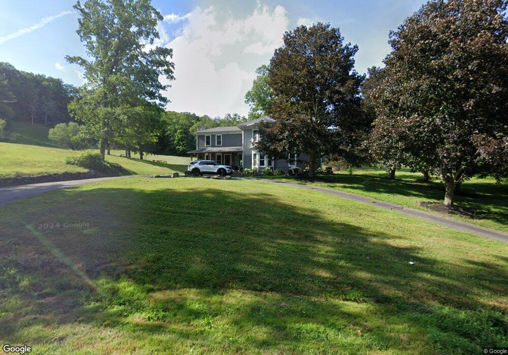
10995 W Caton Rd Corning, NY 14830
Estimated Value: $245,000 - $764,000
5
Beds
5
Baths
4,754
Sq Ft
$99/Sq Ft
Est. Value
About This Home
This home is located at 10995 W Caton Rd, Corning, NY 14830 and is currently estimated at $472,042, approximately $99 per square foot. 10995 W Caton Rd is a home located in Steuben County with nearby schools including Frederick Carder Elementary School, Corning-Painted Post Middle School, and Corning-Painted Post High School.
Ownership History
Date
Name
Owned For
Owner Type
Purchase Details
Closed on
Sep 27, 2019
Sold by
Efthmiou Marcus P and Efthimiou Susan E
Bought by
10995 West Caton Llc
Current Estimated Value
Purchase Details
Closed on
Dec 29, 1998
Sold by
Bailey William D and Bailey Dorian T
Bought by
Efthimiou Marcus P and Efthimiou Susan
Purchase Details
Closed on
Jun 30, 1998
Purchase Details
Closed on
Nov 9, 1995
Sold by
Riesbeck Joyce K
Bought by
Bailey William D and Bailey Dorian T
Create a Home Valuation Report for This Property
The Home Valuation Report is an in-depth analysis detailing your home's value as well as a comparison with similar homes in the area
Home Values in the Area
Average Home Value in this Area
Purchase History
| Date | Buyer | Sale Price | Title Company |
|---|---|---|---|
| 10995 West Caton Llc | -- | -- | |
| Efthimiou Marcus P | $190,000 | -- | |
| -- | -- | -- | |
| Bailey William D | $251,000 | -- |
Source: Public Records
Tax History Compared to Growth
Tax History
| Year | Tax Paid | Tax Assessment Tax Assessment Total Assessment is a certain percentage of the fair market value that is determined by local assessors to be the total taxable value of land and additions on the property. | Land | Improvement |
|---|---|---|---|---|
| 2024 | $7,830 | $241,000 | $51,000 | $190,000 |
| 2023 | $7,903 | $241,000 | $51,000 | $190,000 |
| 2022 | $7,578 | $241,000 | $51,000 | $190,000 |
| 2021 | $6,899 | $190,000 | $46,600 | $143,400 |
| 2020 | $4,482 | $190,000 | $46,600 | $143,400 |
| 2019 | $44 | $190,000 | $46,600 | $143,400 |
| 2018 | $11,748 | $345,300 | $46,600 | $298,700 |
| 2017 | $13,386 | $352,500 | $41,300 | $311,200 |
| 2016 | $13,352 | $352,500 | $41,300 | $311,200 |
| 2015 | -- | $352,500 | $41,300 | $311,200 |
| 2014 | -- | $352,500 | $41,300 | $311,200 |
Source: Public Records
Map
Nearby Homes
- 0 Caton Rd Unit R1640864
- 0 Caton Rd Unit R1637646
- 2085 Caton Rd
- 0 Davis Rd
- 1653 Caton Rd
- 1594 Thurber Rd
- 1536 Thurber Rd
- 1860 Whiskey Creek Rd
- 11014 Wolcott Rd
- 10843 Caton Crescent
- 2602-2606 Bailey Creek Rd
- 2497 Caton Rd
- 10614 Skyline Dr
- 2789 Bailey Creek Rd
- 1964 Spencer Hill Rd
- 1238 Caton Rd
- 31 Caton Rd
- 10493 Skyline Dr
- 19 S Maple St
- 11 Caton Rd
- 10981 W Caton Rd
- 10998 W Caton Rd
- 10986 W Caton Rd
- 10974 W Caton Rd Unit A
- 11015 W Caton Rd
- 11010 W Caton Rd
- 11008 W Caton Rd Unit B
- 00 Caton Rd
- 0 Caton Rd
- 2422 Caton Rd
- 00 River Rd
- 1871 Riff Rd
- 2005 Caton Rd
- 1987 Caton Rd
- 1822 Caton Rd
- 1980 Riff Rd
- 1251 Caton Rd
- 2015 Riff Rd
- 10894 W Caton Rd Unit A
- 2039 Caton Rd