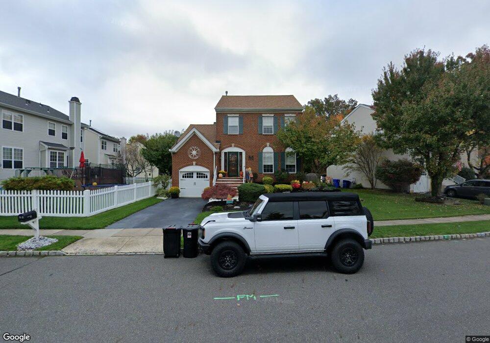
11 Arrowhead Dr Burlington, NJ 08016
Estimated Value: $491,000 - $556,000
Studio
--
Bath
1,817
Sq Ft
$288/Sq Ft
Est. Value
About This Home
This home is located at 11 Arrowhead Dr, Burlington, NJ 08016 and is currently estimated at $523,750, approximately $288 per square foot. 11 Arrowhead Dr is a home located in Burlington County with nearby schools including B Bernice Young Elementary School, Fountain Woods Elementary School, and Burlington Township Middle School at Springside.
Ownership History
Date
Name
Owned For
Owner Type
Purchase Details
Closed on
Jan 18, 2004
Sold by
Mitchell Lawrence Ws and Mitchell Karen
Bought by
Morris Robert J and Morris Donna M
Current Estimated Value
Home Financials for this Owner
Home Financials are based on the most recent Mortgage that was taken out on this home.
Original Mortgage
$275,500
Interest Rate
5.56%
Mortgage Type
Purchase Money Mortgage
Purchase Details
Closed on
Nov 29, 1999
Sold by
Smith Michael F and Smith Eileen M
Bought by
Mitchell Lawrence W S
Home Financials for this Owner
Home Financials are based on the most recent Mortgage that was taken out on this home.
Original Mortgage
$179,010
Interest Rate
7.73%
Mortgage Type
VA
Purchase Details
Closed on
May 31, 1994
Sold by
K Hovnanian At Burlington Inc
Bought by
Smith Michael F and Smith Eileen M
Create a Home Valuation Report for This Property
The Home Valuation Report is an in-depth analysis detailing your home's value as well as a comparison with similar homes in the area
Home Values in the Area
Average Home Value in this Area
Purchase History
| Date | Buyer | Sale Price | Title Company |
|---|---|---|---|
| Morris Robert J | $290,000 | -- | |
| Mitchell Lawrence W S | $175,500 | -- | |
| Smith Michael F | $160,629 | Eastern Title Agency Inc |
Source: Public Records
Mortgage History
| Date | Status | Borrower | Loan Amount |
|---|---|---|---|
| Previous Owner | Morris Robert J | $275,500 | |
| Previous Owner | Mitchell Lawrence W S | $179,010 |
Source: Public Records
Tax History
| Year | Tax Paid | Tax Assessment Tax Assessment Total Assessment is a certain percentage of the fair market value that is determined by local assessors to be the total taxable value of land and additions on the property. | Land | Improvement |
|---|---|---|---|---|
| 2025 | $7,601 | $250,700 | $72,100 | $178,600 |
| 2024 | $7,488 | $250,700 | $72,100 | $178,600 |
| 2023 | $7,488 | $250,700 | $72,100 | $178,600 |
| 2022 | $7,456 | $250,700 | $72,100 | $178,600 |
| 2021 | $7,531 | $250,700 | $72,100 | $178,600 |
| 2020 | $7,513 | $250,700 | $72,100 | $178,600 |
| 2019 | $7,531 | $250,700 | $72,100 | $178,600 |
| 2018 | $7,418 | $250,700 | $72,100 | $178,600 |
| 2017 | $7,373 | $250,700 | $72,100 | $178,600 |
| 2016 | $7,740 | $258,000 | $60,000 | $198,000 |
| 2015 | $7,606 | $258,000 | $60,000 | $198,000 |
| 2014 | $7,327 | $258,000 | $60,000 | $198,000 |
Source: Public Records
Map
Nearby Homes
- 26 Shawnee Trail
- 79 Steeplechase Blvd
- 47 Fountain Blvd
- 3 Horseshoe Dr
- 37 Equestrian Dr
- 11 Knights Ct
- 25 Latimer Way
- 22 Faulkner Ct Unit 22
- 16 Langrock Way
- 13 Lancaster Dr
- 3 Parker Ave
- 505 Neck Rd
- 3 Evergreen Ln
- 441 Independence Dr
- 1004 Armistice Dr
- 431 Independence Dr
- 114 Connor Ct
- 955 Easter Rd
- 952 Columbus Rd
- 948 Easter Rd
- 13 Arrowhead Dr
- 2 Cherokee Trail
- 4 Cherokee Trail
- 15 Arrowhead Dr
- 6 Cherokee Trail
- 8 Cherokee Trail
- 1 Cherokee Trail
- 10 Cherokee Trail
- 12 Cherokee Trail
- 5 Cherokee Trail
- 9 Arrowhead Dr
- 14 Cherokee Trail
- 7 Cherokee Trail
- 38 Tomahawk Dr
- 7 Arrowhead Dr
- 16 Cherokee Trail
- 32 Tomahawk Dr
- 34 Tomahawk Dr
- 30 Tomahawk Dr
- 28 Tomahawk Dr
Your Personal Tour Guide
Ask me questions while you tour the home.