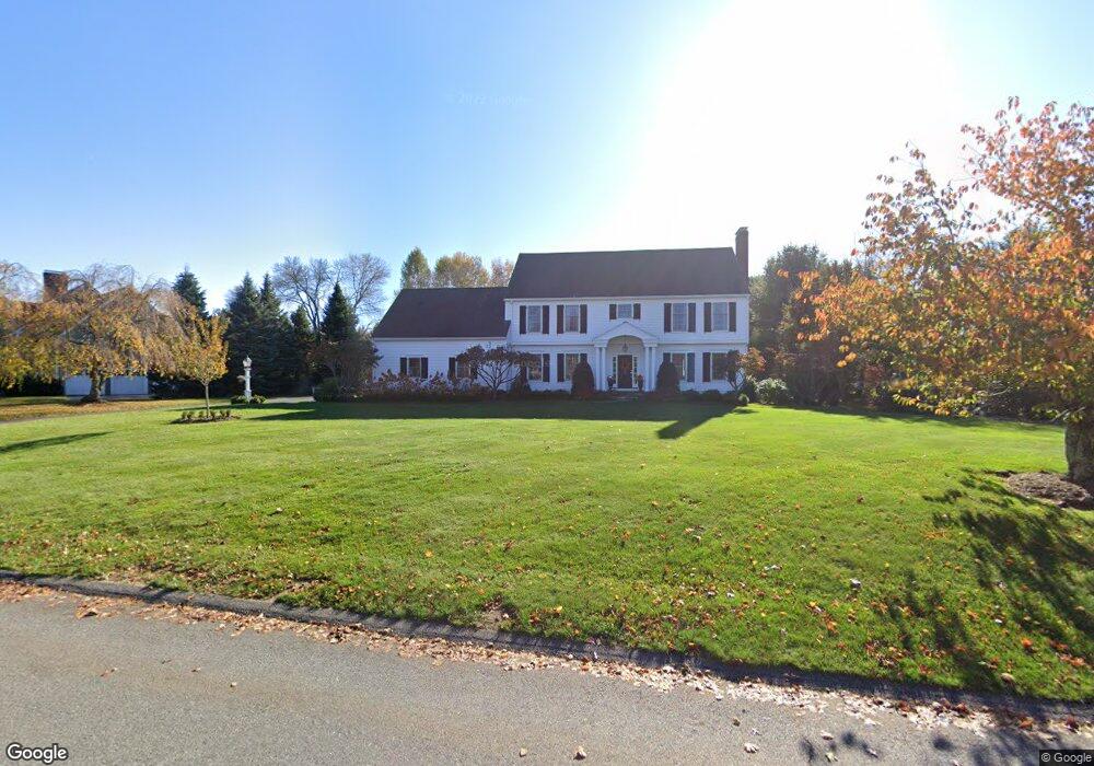
11 Atkinson Ln Sudbury, MA 01776
Estimated Value: $1,661,000 - $2,040,000
4
Beds
5
Baths
5,380
Sq Ft
$330/Sq Ft
Est. Value
About This Home
This home is located at 11 Atkinson Ln, Sudbury, MA 01776 and is currently estimated at $1,777,312, approximately $330 per square foot. 11 Atkinson Ln is a home located in Middlesex County with nearby schools including Peter Noyes Elementary School, Ephraim Curtis Middle School, and Lincoln-Sudbury Regional High School.
Ownership History
Date
Name
Owned For
Owner Type
Purchase Details
Closed on
Mar 23, 2023
Sold by
Erbafina David and Erbafina Mary P
Bought by
2023 David Erbafina T and 2023 Erbafina
Current Estimated Value
Purchase Details
Closed on
Mar 5, 2010
Sold by
Plunkettt Jeffrey D and Plunkettt Robin B
Bought by
Erbafina David and Erbafina Mary P
Home Financials for this Owner
Home Financials are based on the most recent Mortgage that was taken out on this home.
Original Mortgage
$127,000
Interest Rate
5%
Mortgage Type
Purchase Money Mortgage
Purchase Details
Closed on
Oct 7, 1987
Sold by
R K K Rt
Bought by
Plunkett Jeffrey D
Create a Home Valuation Report for This Property
The Home Valuation Report is an in-depth analysis detailing your home's value as well as a comparison with similar homes in the area
Home Values in the Area
Average Home Value in this Area
Purchase History
| Date | Buyer | Sale Price | Title Company |
|---|---|---|---|
| 2023 David Erbafina T | -- | None Available | |
| Erbafina David | $1,035,000 | -- | |
| Erbafina David | $1,035,000 | -- | |
| Plunkett Jeffrey D | $579,000 | -- |
Source: Public Records
Mortgage History
| Date | Status | Borrower | Loan Amount |
|---|---|---|---|
| Previous Owner | Plunkett Jeffrey D | $100,000 | |
| Previous Owner | Erbafina David | $127,000 | |
| Previous Owner | Plunkett Jeffrey D | $227,150 |
Source: Public Records
Tax History
| Year | Tax Paid | Tax Assessment Tax Assessment Total Assessment is a certain percentage of the fair market value that is determined by local assessors to be the total taxable value of land and additions on the property. | Land | Improvement |
|---|---|---|---|---|
| 2025 | $23,103 | $1,578,100 | $546,800 | $1,031,300 |
| 2024 | $22,198 | $1,519,400 | $530,700 | $988,700 |
| 2023 | $20,520 | $1,301,200 | $473,900 | $827,300 |
| 2022 | $20,010 | $1,108,600 | $434,700 | $673,900 |
| 2021 | $18,841 | $1,000,600 | $434,700 | $565,900 |
| 2020 | $18,461 | $1,000,600 | $434,700 | $565,900 |
| 2019 | $17,921 | $1,000,600 | $434,700 | $565,900 |
| 2018 | $17,557 | $979,200 | $462,300 | $516,900 |
| 2017 | $17,206 | $969,900 | $457,900 | $512,000 |
| 2016 | $16,689 | $937,600 | $440,300 | $497,300 |
| 2015 | $16,257 | $923,700 | $436,300 | $487,400 |
| 2014 | $16,268 | $902,300 | $424,700 | $477,600 |
Source: Public Records
Map
Nearby Homes
- 557 Dutton Rd Unit 2
- 15 Harness Ln
- 30 Harness Ln
- 11 Great Lake Dr
- 11 October Rd
- 45 Webster Cir
- 53 Pine St
- 62 Churchill St
- 30 Kendall Rd
- 55 Widow Rites Ln
- 45 Widow Rites Ln
- 8 Twillingate Rd
- 22 Barracks Rd Unit 22
- 111 Willis Rd
- 15 Huckleberry Ln
- 30 Rolling Ln
- 788 Main St
- 0 Robbins Rd
- 786 Main St
- 8 Shoreline Dr Unit 11
- 19 Atkinson Ln
- 5 Atkinson Ln
- 584 Dutton Rd
- 11 Peterson Cir
- 10 Atkinson Ln
- 18 Atkinson Ln
- 0 Atkinson Ln Unit 71611443
- 4 Atkinson Ln
- 576 Dutton Rd
- 26 Atkinson Ln
- 31 Atkinson Ln
- 599 Dutton Rd
- 15 Peterson Cir
- 2 Moore Rd
- 608 Dutton Rd
- Lot 2B Moore Rd
- 587 Dutton Rd
- 32 Atkinson Ln
- 435 Hudson Rd
- 558 Dutton Rd
Your Personal Tour Guide
Ask me questions while you tour the home.