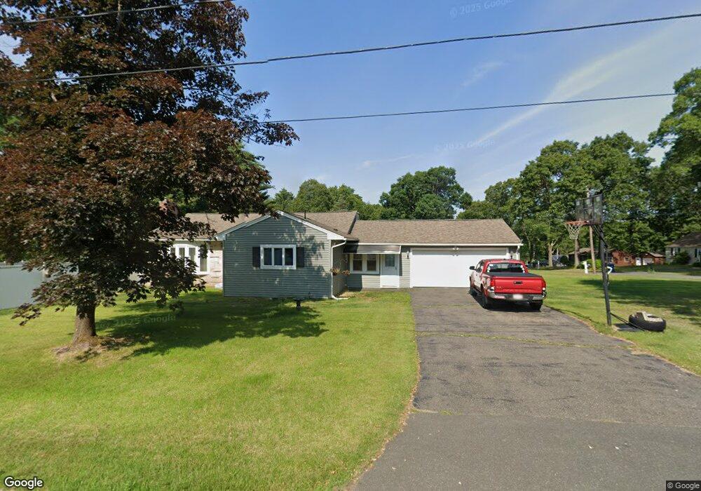
11 Birch St Wilbraham, MA 01095
Estimated Value: $435,932 - $497,000
3
Beds
2
Baths
1,548
Sq Ft
$300/Sq Ft
Est. Value
About This Home
This home is located at 11 Birch St, Wilbraham, MA 01095 and is currently estimated at $463,733, approximately $299 per square foot. 11 Birch St is a home located in Hampden County with nearby schools including Minnechaug Regional High School, Springfield International Charter School, and Wilbraham & Monson Academy.
Ownership History
Date
Name
Owned For
Owner Type
Purchase Details
Closed on
Apr 27, 2023
Sold by
Ochs Lawrence J and Ochs Carol A
Bought by
Ochs John B
Current Estimated Value
Purchase Details
Closed on
May 24, 1996
Sold by
Nelson Vera M
Bought by
Laware Donald F
Create a Home Valuation Report for This Property
The Home Valuation Report is an in-depth analysis detailing your home's value as well as a comparison with similar homes in the area
Home Values in the Area
Average Home Value in this Area
Purchase History
| Date | Buyer | Sale Price | Title Company |
|---|---|---|---|
| Ochs John B | -- | None Available | |
| Laware Donald F | $137,900 | -- |
Source: Public Records
Mortgage History
| Date | Status | Borrower | Loan Amount |
|---|---|---|---|
| Previous Owner | Laware Donald F | $60,600 | |
| Previous Owner | Laware Donald F | $85,000 | |
| Previous Owner | Laware Donald F | $30,000 |
Source: Public Records
Tax History
| Year | Tax Paid | Tax Assessment Tax Assessment Total Assessment is a certain percentage of the fair market value that is determined by local assessors to be the total taxable value of land and additions on the property. | Land | Improvement |
|---|---|---|---|---|
| 2025 | $7,136 | $399,100 | $96,800 | $302,300 |
| 2024 | $6,897 | $372,800 | $96,800 | $276,000 |
| 2023 | $6,430 | $344,700 | $96,800 | $247,900 |
| 2022 | $6,430 | $313,800 | $96,800 | $217,000 |
| 2021 | $6,321 | $275,300 | $104,400 | $170,900 |
| 2020 | $6,161 | $275,300 | $104,400 | $170,900 |
| 2019 | $6,050 | $277,500 | $104,400 | $173,100 |
| 2018 | $5,712 | $252,300 | $104,400 | $147,900 |
| 2017 | $5,551 | $252,300 | $104,400 | $147,900 |
| 2016 | $4,901 | $226,900 | $115,800 | $111,100 |
| 2015 | $4,738 | $226,900 | $115,800 | $111,100 |
Source: Public Records
Map
Nearby Homes
- 104 High Pine Cir
- 8 High Pine Cir
- 8 Patriot Ridge Ln
- 172 Main St
- 20 Old Orchard Rd
- 1 Aspen Dr
- 35 Lake Dr
- 46 Washington Rd
- 474 Mountain Rd
- 6 Teak Terrace Unit 24
- 474-480 Mountain Rd
- 6 Hilltop Park
- 592 Stony Hill Rd
- 103 Sandalwood Dr Unit site 00
- 57 Sandalwood Dr Unit site 61
- 84 Sandalwood Dr Unit site 00
- 3 Mohawk St
- 26 Sandalwood Dr
- 36 Maple St
- 15 Cedar Ridge Dr Unit 1
Your Personal Tour Guide
Ask me questions while you tour the home.