Estimated Value: $1,015,000 - $1,174,000
5
Beds
5
Baths
4,278
Sq Ft
$254/Sq Ft
Est. Value
About This Home
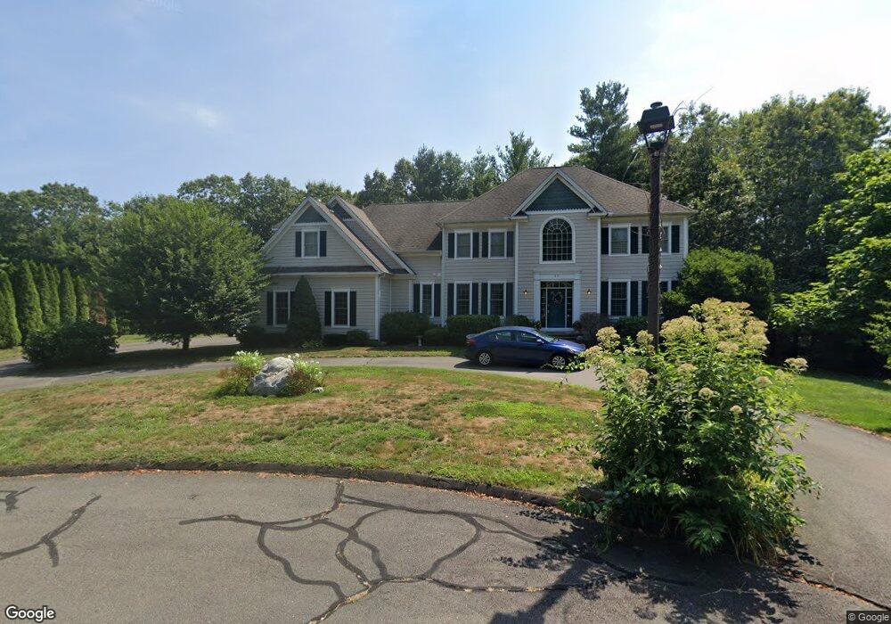
This home is located at 11 Bluestone Ln, Avon, CT 06001 and is currently estimated at $1,087,393, approximately $254 per square foot. 11 Bluestone Ln is a home located in Hartford County with nearby schools including Roaring Brook School, Thompson Brook School, and Avon Middle School.
Ownership History
Date
Name
Owned For
Owner Type
Purchase Details
Closed on
Apr 11, 2023
Sold by
Edgar David A and Edgar Karen M
Bought by
David & Karen Edgar Lt
Current Estimated Value
Purchase Details
Closed on
Jun 25, 1997
Sold by
Camera Deborah M
Bought by
Nolan Sally W
Home Financials for this Owner
Home Financials are based on the most recent Mortgage that was taken out on this home.
Original Mortgage
$110,000
Interest Rate
7.81%
Mortgage Type
Purchase Money Mortgage
Create a Home Valuation Report for This Property
The Home Valuation Report is an in-depth analysis detailing your home's value as well as a comparison with similar homes in the area
Home Values in the Area
Average Home Value in this Area
Purchase History
| Date | Buyer | Sale Price | Title Company |
|---|---|---|---|
| David & Karen Edgar Lt | -- | None Available | |
| David & Karen Edgar Lt | -- | None Available | |
| Nolan Sally W | $192,000 | -- | |
| Nolan Sally W | $192,000 | -- |
Source: Public Records
Mortgage History
| Date | Status | Borrower | Loan Amount |
|---|---|---|---|
| Previous Owner | Nolan Sally W | $550,000 | |
| Previous Owner | Nolan Sally W | $110,000 |
Source: Public Records
Tax History
| Year | Tax Paid | Tax Assessment Tax Assessment Total Assessment is a certain percentage of the fair market value that is determined by local assessors to be the total taxable value of land and additions on the property. | Land | Improvement |
|---|---|---|---|---|
| 2025 | $16,786 | $545,870 | $122,500 | $423,370 |
| 2024 | $16,191 | $545,870 | $122,500 | $423,370 |
| 2023 | $16,001 | $452,120 | $115,500 | $336,620 |
| 2022 | $15,648 | $452,120 | $115,500 | $336,620 |
| 2021 | $15,467 | $452,120 | $115,500 | $336,620 |
| 2020 | $14,875 | $452,120 | $115,500 | $336,620 |
| 2019 | $14,875 | $452,120 | $115,500 | $336,620 |
| 2018 | $14,553 | $464,210 | $122,500 | $341,710 |
| 2017 | $14,200 | $464,210 | $122,500 | $341,710 |
| 2016 | $13,703 | $464,210 | $122,500 | $341,710 |
| 2015 | $13,369 | $464,210 | $122,500 | $341,710 |
| 2014 | $13,146 | $464,210 | $122,500 | $341,710 |
Source: Public Records
Map
Nearby Homes
- 39 High Ridge Hollow
- 26 Berkshire Crossing
- 28 Sepous Rd
- 0 Spielman Hwy
- 373 Collinsville Rd
- 40 Homestead Ln
- 123 Bridgewater Dr
- 12 Verville Rd
- 114 Daniel Trace
- 2 Ventres Way
- 3 Clearwater Ct
- 41 Punch Brook Rd
- 25 Punch Brook Rd
- 61 Weatherstone
- 58 Weatherstone
- 15 Greenwich Ln Unit 15
- 48 Weatherstone
- 4 Tanglewood Dr
- 67 Byron Dr
- 4 Strathmore Ln Unit 4
- 7 Bluestone Ln
- 6 Quincy Place
- 12 Bluestone Ln
- 15 Avondale Dr
- 8 Avondale Dr
- 3 Bluestone Ln
- 3 Quincy Place
- 4 Quincy Place
- 11 Avondale Dr
- 15 Quincy Place
- 11 Quincy Place
- 5 Quincy Place
- 9 Quincy Place
- 16 Bluestone Ln
- 5 Chelsea Place
- 5 Chelsea Place Unit 5
- 2 Quincy Place
- 4 Chelsea Place
- 4 Chelsea Place Unit 4
- 1 Quincy Place
Your Personal Tour Guide
Ask me questions while you tour the home.