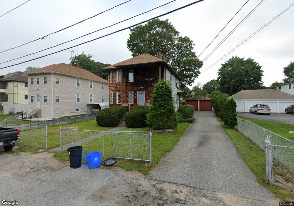
11 Branch Ave North Smithfield, RI 02896
Estimated Value: $406,000 - $494,000
5
Beds
2
Baths
2,140
Sq Ft
$211/Sq Ft
Est. Value
About This Home
This home is located at 11 Branch Ave, North Smithfield, RI 02896 and is currently estimated at $451,575, approximately $211 per square foot. 11 Branch Ave is a home located in Providence County with nearby schools including North Smithfield Elementary School, North Smithfield Middle School, and North Smithfield High School.
Ownership History
Date
Name
Owned For
Owner Type
Purchase Details
Closed on
Dec 28, 2018
Sold by
Petrin Russell K and Petrin Patricia C
Bought by
Petrin Ft 2018 and Petrin
Current Estimated Value
Purchase Details
Closed on
Aug 14, 1974
Bought by
Petrin Russell and Petrin Patricia
Create a Home Valuation Report for This Property
The Home Valuation Report is an in-depth analysis detailing your home's value as well as a comparison with similar homes in the area
Home Values in the Area
Average Home Value in this Area
Purchase History
| Date | Buyer | Sale Price | Title Company |
|---|---|---|---|
| Petrin Ft 2018 | -- | -- | |
| Petrin Ft 2018 | -- | -- | |
| Petrin Russell | -- | -- |
Source: Public Records
Mortgage History
| Date | Status | Borrower | Loan Amount |
|---|---|---|---|
| Previous Owner | Petrin Russell | $45,000 |
Source: Public Records
Tax History
| Year | Tax Paid | Tax Assessment Tax Assessment Total Assessment is a certain percentage of the fair market value that is determined by local assessors to be the total taxable value of land and additions on the property. | Land | Improvement |
|---|---|---|---|---|
| 2025 | $4,143 | $360,300 | $64,800 | $295,500 |
| 2024 | $4,295 | $290,800 | $53,300 | $237,500 |
| 2023 | $4,144 | $290,800 | $53,300 | $237,500 |
| 2022 | $4,045 | $290,800 | $53,300 | $237,500 |
| 2021 | $3,792 | $232,800 | $50,400 | $182,400 |
| 2020 | $3,792 | $232,800 | $50,400 | $182,400 |
| 2019 | $3,695 | $232,800 | $50,400 | $182,400 |
| 2018 | $3,398 | $197,100 | $53,000 | $144,100 |
| 2017 | $3,315 | $197,100 | $53,000 | $144,100 |
| 2016 | $3,225 | $197,100 | $53,000 | $144,100 |
| 2015 | $3,374 | $202,300 | $56,500 | $145,800 |
| 2014 | $3,241 | $202,300 | $56,500 | $145,800 |
Source: Public Records
Map
Nearby Homes
- 470 Saint Paul St
- 6 Obeline Dr
- 53 Maple Ave
- 4 Sharon Pkwy
- 0 10th Ave
- 0 Pound Hill Rd Unit 1403654
- 0 Pound Hill Rd Unit 1403653
- 1 Tupperware Dr Unit 138
- 1 Tupperware Dr Unit 221
- 1 Tupperware Dr Unit 241
- 0 Brentwood Dr
- 29 Graves Ave
- 81 Fountain St
- 34 Smithfield Rd
- 123 4th Ave
- 83 4th Ave
- 104 Old Great Rd
- 92 Rockland Ave
- 168 3rd Ave
- 84 Bernice Ave
- 15 Branch Ave
- 7 Branch Ave
- 640 Great Rd
- 17 Branch Ave
- 638 Great Rd
- 638 Great Rd Unit 1
- 14 Branch Ave
- 16 Branch Ave
- 12 Branch Ave
- 3 Branch Ave
- 636 Great Rd
- 10 Branch Ave
- 10 Branch Ave Unit 1st floor
- 642 Great Rd
- 618 Great Rd
- 644 Great Rd
- 12 Andrews Terrace
- 8 Branch Ave
- 654 Great Rd
- 10A Andrews Terrace
Your Personal Tour Guide
Ask me questions while you tour the home.