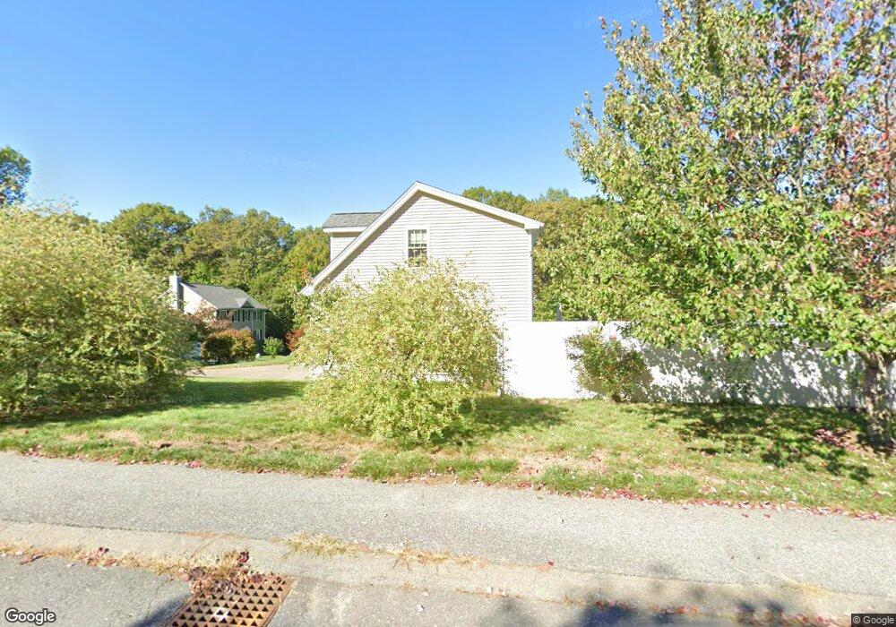
11 Brendan Rd Clinton, MA 01510
Estimated Value: $627,000 - $770,000
4
Beds
3
Baths
2,230
Sq Ft
$304/Sq Ft
Est. Value
About This Home
This home is located at 11 Brendan Rd, Clinton, MA 01510 and is currently estimated at $678,732, approximately $304 per square foot. 11 Brendan Rd is a home located in Worcester County with nearby schools including Clinton Elementary School, Clinton Senior High School, and Clinton Middle School.
Ownership History
Date
Name
Owned For
Owner Type
Purchase Details
Closed on
Nov 14, 2018
Sold by
Christoph George H and Christoph Barbara A
Bought by
Bastien Jennifer A and Christoph George G
Current Estimated Value
Purchase Details
Closed on
Nov 30, 2011
Sold by
Aten Russell H and Aten Julie A
Bought by
Christoph George H and Christoph Barbara A
Purchase Details
Closed on
Aug 29, 2007
Sold by
Nathan Heights Llc
Bought by
Aten Julie A and Aten Russell H
Home Financials for this Owner
Home Financials are based on the most recent Mortgage that was taken out on this home.
Original Mortgage
$150,000
Interest Rate
6.71%
Mortgage Type
Purchase Money Mortgage
Create a Home Valuation Report for This Property
The Home Valuation Report is an in-depth analysis detailing your home's value as well as a comparison with similar homes in the area
Home Values in the Area
Average Home Value in this Area
Purchase History
| Date | Buyer | Sale Price | Title Company |
|---|---|---|---|
| Bastien Jennifer A | -- | -- | |
| Christoph George H | $323,500 | -- | |
| Aten Julie A | $384,900 | -- |
Source: Public Records
Mortgage History
| Date | Status | Borrower | Loan Amount |
|---|---|---|---|
| Previous Owner | Aten Julie A | $150,000 |
Source: Public Records
Tax History Compared to Growth
Tax History
| Year | Tax Paid | Tax Assessment Tax Assessment Total Assessment is a certain percentage of the fair market value that is determined by local assessors to be the total taxable value of land and additions on the property. | Land | Improvement |
|---|---|---|---|---|
| 2025 | $7,149 | $537,500 | $128,300 | $409,200 |
| 2024 | $7,069 | $538,000 | $128,300 | $409,700 |
| 2023 | $6,632 | $496,000 | $116,700 | $379,300 |
| 2022 | $6,596 | $442,400 | $106,100 | $336,300 |
| 2021 | $6,121 | $384,000 | $101,100 | $282,900 |
| 2020 | $5,948 | $384,000 | $101,100 | $282,900 |
| 2019 | $5,943 | $373,100 | $98,100 | $275,000 |
| 2018 | $5,912 | $348,200 | $94,200 | $254,000 |
| 2017 | $5,766 | $326,300 | $94,200 | $232,100 |
| 2016 | $5,730 | $331,800 | $94,200 | $237,600 |
| 2015 | $5,225 | $313,600 | $91,400 | $222,200 |
| 2014 | $5,065 | $313,600 | $91,400 | $222,200 |
Source: Public Records
Map
Nearby Homes
- 30 John F. Kennedy Ave
- 12 Woodruff Rd
- 405 Ridgefield Cir Unit C
- 303 Ridgefield Cir Unit C
- 920 Ridgefield Cir Unit C
- 112 Ridgefield Cir Unit B
- 238 Mill Street Extension
- 103 Ridgefield Cir Unit B
- 459 High St
- 201 Stone St Unit 203
- 201-203 Stone St
- 453 Blue Heron Dr Unit 453
- 216 Walnut St
- 861 Main St
- 155 Cedar St
- 57 Clark St
- 136 Mill St
- 132 Kilbourn Rd
- 1 Grady St
- 22 Forest Ave