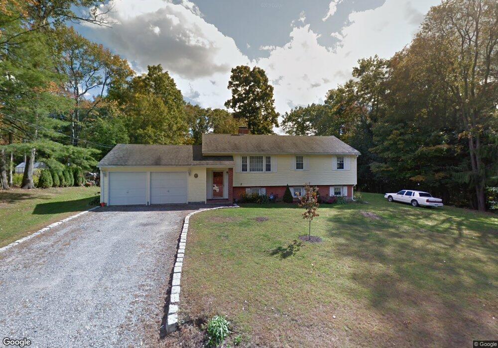
11 Bull Rd Harwinton, CT 06791
Estimated Value: $332,000 - $388,000
3
Beds
2
Baths
1,014
Sq Ft
$355/Sq Ft
Est. Value
About This Home
This home is located at 11 Bull Rd, Harwinton, CT 06791 and is currently estimated at $360,111, approximately $355 per square foot. 11 Bull Rd is a home located in Litchfield County with nearby schools including Harwinton Consolidated School, Har-Bur Middle School, and Lewis S. Mills High School.
Ownership History
Date
Name
Owned For
Owner Type
Purchase Details
Closed on
Dec 29, 2005
Sold by
Courtright Barbara and Courtright Raymond
Bought by
Courtright Stephen
Current Estimated Value
Home Financials for this Owner
Home Financials are based on the most recent Mortgage that was taken out on this home.
Original Mortgage
$192,000
Outstanding Balance
$108,063
Interest Rate
6.39%
Estimated Equity
$252,048
Purchase Details
Closed on
May 27, 2004
Sold by
Berube Mary Ann
Bought by
Courtright Barbara and Courtright Raymond
Home Financials for this Owner
Home Financials are based on the most recent Mortgage that was taken out on this home.
Original Mortgage
$182,400
Interest Rate
5.88%
Purchase Details
Closed on
Sep 28, 1990
Sold by
Roterson Karl H
Bought by
Berube Mark E
Create a Home Valuation Report for This Property
The Home Valuation Report is an in-depth analysis detailing your home's value as well as a comparison with similar homes in the area
Home Values in the Area
Average Home Value in this Area
Purchase History
| Date | Buyer | Sale Price | Title Company |
|---|---|---|---|
| Courtright Stephen | $250,000 | -- | |
| Courtright Stephen | $250,000 | -- | |
| Courtright Barbara | $228,000 | -- | |
| Courtright Barbara | $228,000 | -- | |
| Berube Mark E | $172,000 | -- |
Source: Public Records
Mortgage History
| Date | Status | Borrower | Loan Amount |
|---|---|---|---|
| Open | Berube Mark E | $192,000 | |
| Closed | Berube Mark E | $192,000 | |
| Previous Owner | Berube Mark E | $182,400 |
Source: Public Records
Tax History Compared to Growth
Tax History
| Year | Tax Paid | Tax Assessment Tax Assessment Total Assessment is a certain percentage of the fair market value that is determined by local assessors to be the total taxable value of land and additions on the property. | Land | Improvement |
|---|---|---|---|---|
| 2025 | $4,422 | $192,280 | $62,550 | $129,730 |
| 2024 | $4,403 | $192,280 | $62,550 | $129,730 |
| 2023 | $4,305 | $147,420 | $44,670 | $102,750 |
| 2022 | $4,201 | $147,420 | $44,670 | $102,750 |
| 2021 | $4,231 | $147,420 | $44,670 | $102,750 |
| 2020 | $4,128 | $147,420 | $44,670 | $102,750 |
| 2019 | $4,128 | $147,420 | $44,670 | $102,750 |
| 2018 | $3,983 | $142,250 | $49,630 | $92,620 |
| 2017 | $3,955 | $142,250 | $49,630 | $92,620 |
| 2016 | $3,955 | $142,250 | $49,630 | $92,620 |
| 2015 | $3,883 | $142,250 | $49,630 | $92,620 |
| 2014 | $3,827 | $142,250 | $49,630 | $92,620 |
Source: Public Records
Map
Nearby Homes
- 25 Plymouth Rd
- 21 South Rd
- 83 Shingle Mill Rd
- 164 Birge Park Rd
- 74 Pine Ridge Dr
- 183 Wildcat Hill Rd
- 39 Orchard Hill Rd
- 448 Litchfield Rd
- 12 Break Maiden Ln
- Lot 2 Birch Hill Rd
- 9 Steeple Chase Rd
- 530 Wildcat Hill Rd
- 0 Campville Hill Rd
- 544 Litchfield Rd
- 29 Branch Rd
- 195 County Line Rd
- 92 Shafer Rd
- 73 Shirley Rd
- 65 Oak Meadow Ln Unit 65
- 21 Oak Meadow Ln