
Seller's Agent in 2025
Dee Webster
Lamacchia Realty, Inc.
(508) 245-9458
1 in this area
72 Total Sales

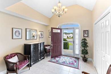
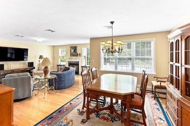
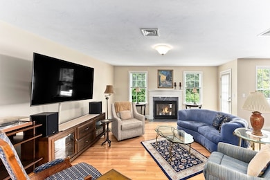

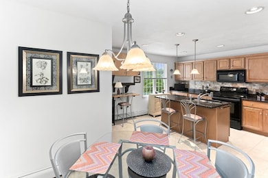
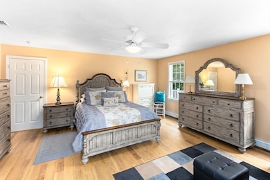
Welcome to easy living at Horton Estates — where 55+ means you're old enough to know better, and young enough to still want a great community. This detached condo is in pristine condition and offers the best of one-level living with 3 bedrooms, 2 baths, and an open floor plan that feels both spacious and cozy.Whip up dinner (or reheat takeout in style) in the kitchen, which features stainless steel appliances, granite countertops, and more cabinets than you'll know what to do with. The living and dining areas flow together perfectly for entertaining — or just binge-watching your latest Netflix obsession by the propane fireplace.The roomy primary suite is a little slice of heaven, complete with two generous closets and a private en-suite bath. Guest bedrooms are tucked away on the opposite end for peace and quiet, or they can moonlight as a home office, den, or your very own
| Date | Type | Sale Price | Title Company |
|---|---|---|---|
| Quit Claim Deed | $630,000 | -- | |
| Deed | -- | -- | |
| Deed | -- | -- | |
| Deed | $369,658 | -- | |
| Deed | $369,658 | -- | |
| Deed | $428,185 | -- | |
| Deed | $428,185 | -- |
| Date | Status | Loan Amount | Loan Type |
|---|---|---|---|
| Open | $504,000 | Purchase Money Mortgage | |
| Previous Owner | $530,000 | Purchase Money Mortgage | |
| Previous Owner | $35,000 | Purchase Money Mortgage |
| Date | Event | Price | List to Sale | Price per Sq Ft |
|---|---|---|---|---|
| 10/31/2025 10/31/25 | Sold | $630,000 | 0.0% | $285 / Sq Ft |
| 09/12/2025 09/12/25 | Pending | -- | -- | -- |
| 09/10/2025 09/10/25 | Price Changed | $630,000 | -2.9% | $285 / Sq Ft |
| 08/26/2025 08/26/25 | For Sale | $649,000 | +3.0% | $294 / Sq Ft |
| 07/31/2025 07/31/25 | Off Market | $630,000 | -- | -- |
| 07/25/2025 07/25/25 | For Sale | $649,000 | 0.0% | $294 / Sq Ft |
| 07/23/2025 07/23/25 | Pending | -- | -- | -- |
| 07/16/2025 07/16/25 | For Sale | $649,000 | -- | $294 / Sq Ft |
| Year | Tax Paid | Tax Assessment Tax Assessment Total Assessment is a certain percentage of the fair market value that is determined by local assessors to be the total taxable value of land and additions on the property. | Land | Improvement |
|---|---|---|---|---|
| 2025 | $61 | $550,600 | $0 | $550,600 |
| 2024 | $6,408 | $564,100 | $0 | $564,100 |
| 2023 | $5,296 | $479,100 | $0 | $479,100 |
| 2022 | $5,296 | $418,000 | $0 | $418,000 |
| 2021 | $5,599 | $422,900 | $0 | $422,900 |
| 2020 | $5,274 | $402,000 | $0 | $402,000 |
| 2018 | $4,356 | $363,900 | $0 | $363,900 |
| 2017 | $4,004 | $318,800 | $0 | $318,800 |
| 2016 | $3,873 | $318,800 | $0 | $318,800 |
| 2015 | $3,968 | $322,300 | $0 | $322,300 |
| 2014 | $4,009 | $322,300 | $0 | $322,300 |
Seller's Agent in 2025
Dee Webster
Lamacchia Realty, Inc.
(508) 245-9458
1 in this area
72 Total Sales
K
Buyer's Agent in 2025
Kendell Moniz-Amaral
revolv of Dartmouth
(508) 901-5265
2 in this area
47 Total Sales
Source: MLS Property Information Network (MLS PIN)
MLS Number: 73404276
APN: REHO-000022-000098-000002
Disclaimer: Certain information contained herein is derived from information provided by parties other than Homes.com. All information provided is deemed reliable, but is not guaranteed to be accurate and should be independently verified.
![]() The property listing data and information, or the Images, set forth herein were provided to MLS Property Information Network, Inc. from third party sources, including sellers, lessors and public records, and were compiled by MLS Property Information Network, Inc. The property listing data and information, and the Images, are for the personal, non-commercial use of consumers having a good faith interest in purchasing or leasing listed properties of the type displayed to them and may not be used for any purpose other than to identify prospective properties which such consumers may have a good faith interest in purchasing or leasing. MLS Property Information Network, Inc. and its subscribers disclaim any and all representations and warranties as to the accuracy of the property listing data and information, or as to the accuracy of any of the Images, set forth herein.
The property listing data and information, or the Images, set forth herein were provided to MLS Property Information Network, Inc. from third party sources, including sellers, lessors and public records, and were compiled by MLS Property Information Network, Inc. The property listing data and information, and the Images, are for the personal, non-commercial use of consumers having a good faith interest in purchasing or leasing listed properties of the type displayed to them and may not be used for any purpose other than to identify prospective properties which such consumers may have a good faith interest in purchasing or leasing. MLS Property Information Network, Inc. and its subscribers disclaim any and all representations and warranties as to the accuracy of the property listing data and information, or as to the accuracy of any of the Images, set forth herein.