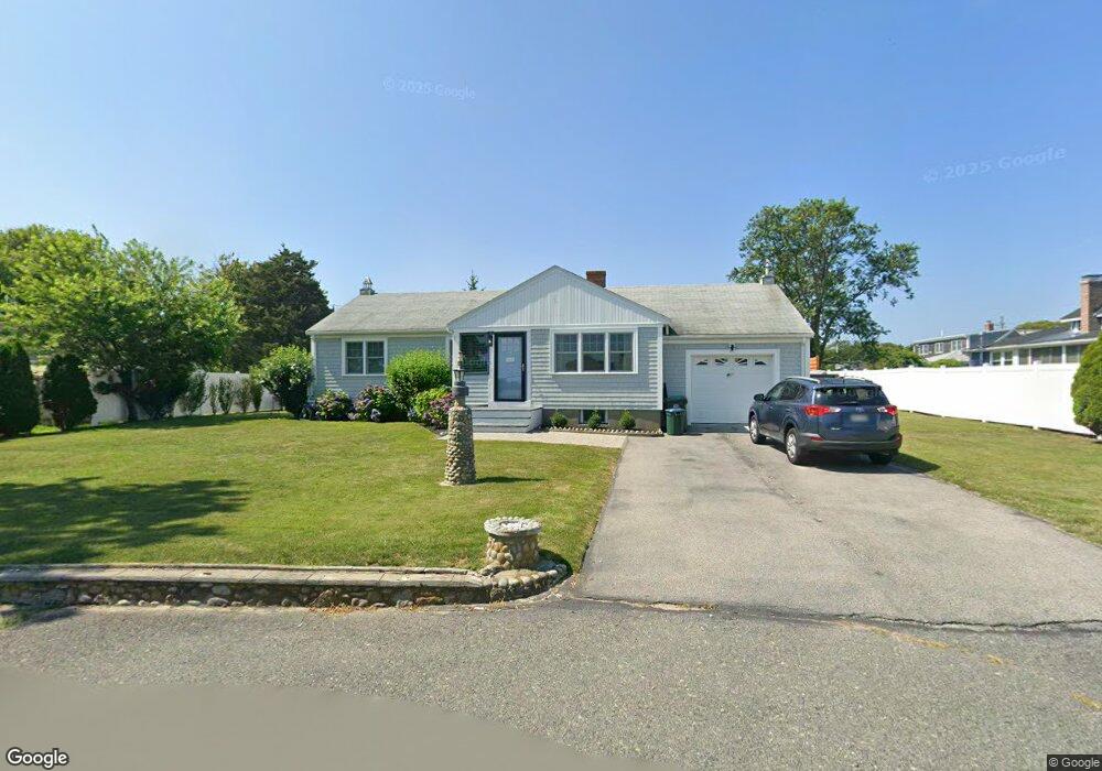
11 Diane Way Marshfield, MA 02050
Ocean Bluff-Brant Rock NeighborhoodEstimated Value: $704,503 - $781,000
3
Beds
2
Baths
1,366
Sq Ft
$534/Sq Ft
Est. Value
About This Home
This home is located at 11 Diane Way, Marshfield, MA 02050 and is currently estimated at $729,126, approximately $533 per square foot. 11 Diane Way is a home with nearby schools including Governor Edward Winslow School, Furnace Brook Middle School, and Marshfield High School.
Ownership History
Date
Name
Owned For
Owner Type
Purchase Details
Closed on
Jul 5, 2023
Sold by
John Conneely 1991 Ret and Conneely
Bought by
Wencis Mark and Wencis Donna
Current Estimated Value
Purchase Details
Closed on
Oct 7, 1996
Sold by
Est Morrison John T and Albanese Benjamin P
Bought by
Callan Maureen A and Callan John B
Home Financials for this Owner
Home Financials are based on the most recent Mortgage that was taken out on this home.
Original Mortgage
$45,000
Interest Rate
7.9%
Mortgage Type
Purchase Money Mortgage
Purchase Details
Closed on
Jan 31, 1996
Sold by
Morrison Ft and Morrissey Mary D
Bought by
Callan Maureen A and Callan John B
Home Financials for this Owner
Home Financials are based on the most recent Mortgage that was taken out on this home.
Original Mortgage
$45,000
Interest Rate
7.25%
Mortgage Type
Purchase Money Mortgage
Purchase Details
Closed on
May 14, 1991
Sold by
Dwyer William C and Cwyer Elaine E
Bought by
Morrison John T
Create a Home Valuation Report for This Property
The Home Valuation Report is an in-depth analysis detailing your home's value as well as a comparison with similar homes in the area
Home Values in the Area
Average Home Value in this Area
Purchase History
| Date | Buyer | Sale Price | Title Company |
|---|---|---|---|
| Wencis Mark | -- | None Available | |
| Callan Maureen A | $5,000 | -- | |
| Callan Maureen A | $5,000 | -- | |
| Callan Maureen A | $152,000 | -- | |
| Callan Maureen A | $152,000 | -- | |
| Morrison John T | $144,000 | -- | |
| Morrison John T | $144,000 | -- |
Source: Public Records
Mortgage History
| Date | Status | Borrower | Loan Amount |
|---|---|---|---|
| Previous Owner | Morrison John T | $45,000 | |
| Previous Owner | Morrison John T | $45,000 |
Source: Public Records
Tax History Compared to Growth
Tax History
| Year | Tax Paid | Tax Assessment Tax Assessment Total Assessment is a certain percentage of the fair market value that is determined by local assessors to be the total taxable value of land and additions on the property. | Land | Improvement |
|---|---|---|---|---|
| 2025 | $5,661 | $571,800 | $322,300 | $249,500 |
| 2024 | $5,471 | $526,600 | $302,200 | $224,400 |
| 2023 | $5,412 | $478,100 | $272,000 | $206,100 |
| 2022 | $5,260 | $406,200 | $231,700 | $174,500 |
| 2021 | $5,054 | $383,200 | $221,600 | $161,600 |
| 2020 | $4,668 | $350,200 | $191,400 | $158,800 |
| 2019 | $4,474 | $334,400 | $191,400 | $143,000 |
| 2018 | $4,415 | $330,200 | $191,400 | $138,800 |
| 2017 | $4,311 | $314,200 | $181,300 | $132,900 |
| 2016 | $4,061 | $292,600 | $171,200 | $121,400 |
| 2015 | $3,707 | $278,900 | $171,200 | $107,700 |
| 2014 | $3,656 | $275,100 | $171,200 | $103,900 |
Source: Public Records
Map
Nearby Homes
- 63 Chickatawbut Ave
- 3 Diane Way
- 21 Diane Way
- 14 Pamela Way
- 55 Chickatawbut Ave
- 12 Diane Way
- 73 Chickatawbut Ave
- 24 Pamela Way
- 50 Massasoit Ave
- 66 Chickatawbut Ave
- 83 Chickatawbut Ave
- 185 Plymouth Ave
- 177 Plymouth Ave
- 65 Massasoit Ave
- 60 Chickatawbut Ave
- 169 Plymouth Ave
- 53 Massasoit Ave
- 8 Agawam Ave
- 56 Chickatawbut Ave
- 53 Massasoit Ave