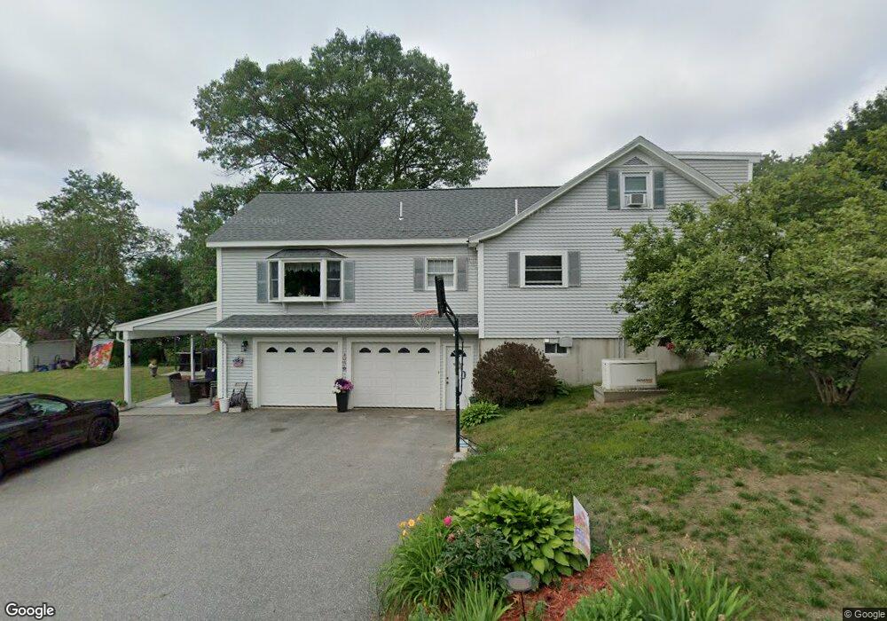
11 Doyle Ave Dracut, MA 01826
Estimated Value: $776,194 - $902,000
4
Beds
5
Baths
3,276
Sq Ft
$255/Sq Ft
Est. Value
About This Home
This home is located at 11 Doyle Ave, Dracut, MA 01826 and is currently estimated at $834,549, approximately $254 per square foot. 11 Doyle Ave is a home located in Middlesex County with nearby schools including George H. Englesby Elementary School, Richardson Middle School, and Dracut Senior High School.
Ownership History
Date
Name
Owned For
Owner Type
Purchase Details
Closed on
Apr 25, 2023
Sold by
Plourde William M and Plourde Elaine C
Bought by
Doyle Avenue Ret
Current Estimated Value
Purchase Details
Closed on
Aug 27, 1987
Sold by
Plourde Maurice
Bought by
Plourde Wm M
Create a Home Valuation Report for This Property
The Home Valuation Report is an in-depth analysis detailing your home's value as well as a comparison with similar homes in the area
Home Values in the Area
Average Home Value in this Area
Purchase History
| Date | Buyer | Sale Price | Title Company |
|---|---|---|---|
| Doyle Avenue Ret | -- | None Available | |
| Plourde Wm M | $35,000 | -- |
Source: Public Records
Mortgage History
| Date | Status | Borrower | Loan Amount |
|---|---|---|---|
| Previous Owner | Plourde Wm M | $200,000 | |
| Previous Owner | Plourde Wm M | $27,000 | |
| Previous Owner | Plourde Wm M | $45,000 |
Source: Public Records
Tax History Compared to Growth
Tax History
| Year | Tax Paid | Tax Assessment Tax Assessment Total Assessment is a certain percentage of the fair market value that is determined by local assessors to be the total taxable value of land and additions on the property. | Land | Improvement |
|---|---|---|---|---|
| 2025 | $7,623 | $753,300 | $205,900 | $547,400 |
| 2024 | $7,283 | $696,900 | $196,100 | $500,800 |
| 2023 | $7,315 | $631,700 | $170,600 | $461,100 |
| 2022 | $7,260 | $590,700 | $155,000 | $435,700 |
| 2021 | $9,288 | $541,800 | $140,800 | $401,000 |
| 2020 | $1,517 | $507,900 | $136,600 | $371,300 |
| 2019 | $8,699 | $505,900 | $130,000 | $375,900 |
| 2018 | $6,175 | $436,700 | $130,000 | $306,700 |
| 2017 | $9,725 | $436,700 | $130,000 | $306,700 |
| 2016 | $5,488 | $369,800 | $125,000 | $244,800 |
| 2015 | $5,337 | $357,500 | $125,000 | $232,500 |
| 2014 | $5,037 | $347,600 | $125,000 | $222,600 |
Source: Public Records
Map
Nearby Homes
- 100 Cass Ave Unit A13
- 14 Louis Farm Rd Unit 14
- 157 Old Rd
- 15 Louis Farm Rd Unit 15
- 174 Old Rd
- 190 Old Rd
- 94 Hampson St
- 148 Flower Ln Unit 14
- 161 Flower Ln Unit 5
- 101 Donohue Rd Unit 19
- 101 Donohue Rd Unit 3
- 20 Dean Ave
- 45 Hoover St
- 999 Hildreth St
- 83 Turgeon Ave
- 57 Lantern Ln Unit 3
- 49 Sparks St
- 37 Beaudry St
- 109 Navy Yard Rd
- 74 Tennis Plaza Rd Unit 34