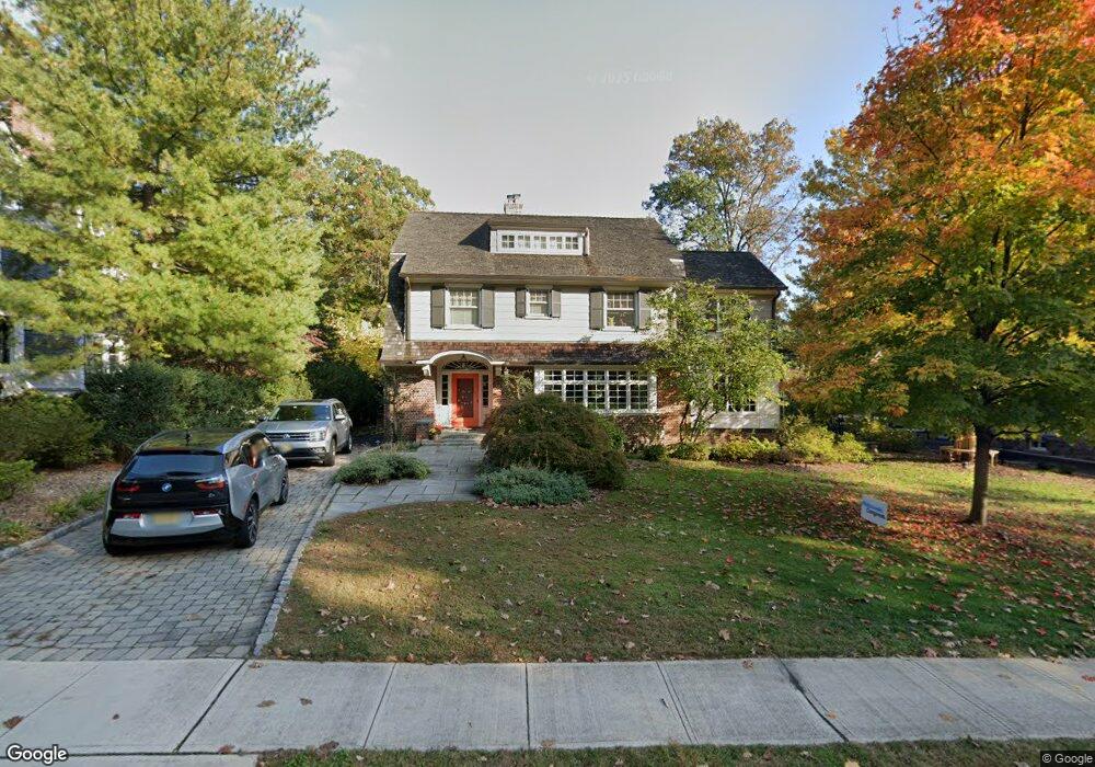
11 Fernwood Rd Summit, NJ 07901
Estimated Value: $3,020,614 - $3,284,000
--
Bed
--
Bath
3,812
Sq Ft
$838/Sq Ft
Est. Value
About This Home
This home is located at 11 Fernwood Rd, Summit, NJ 07901 and is currently estimated at $3,195,538, approximately $838 per square foot. 11 Fernwood Rd is a home located in Union County with nearby schools including L C Johnson Summit Middle School, Summit Sr High School, and Kent Place School.
Ownership History
Date
Name
Owned For
Owner Type
Purchase Details
Closed on
Apr 27, 2023
Sold by
Richter Monica and Richter Wolfgang
Bought by
Mrwg Family Trust
Current Estimated Value
Purchase Details
Closed on
Jun 17, 2011
Sold by
Sanborn Mark W and Sanborn Kristin L
Bought by
Richter Monica and Guenther Wolfgang
Purchase Details
Closed on
Aug 18, 2008
Sold by
Kenney John M and Kenney Lizanne
Bought by
Sanborn Mark W and Sanborn Kristin L
Home Financials for this Owner
Home Financials are based on the most recent Mortgage that was taken out on this home.
Original Mortgage
$1,000,000
Interest Rate
5.75%
Mortgage Type
Purchase Money Mortgage
Purchase Details
Closed on
Feb 21, 1996
Sold by
Coyer Barbara B and Biglow Ernest C
Bought by
Kenney John M and Kenney Lizanne T
Create a Home Valuation Report for This Property
The Home Valuation Report is an in-depth analysis detailing your home's value as well as a comparison with similar homes in the area
Home Values in the Area
Average Home Value in this Area
Purchase History
| Date | Buyer | Sale Price | Title Company |
|---|---|---|---|
| Mrwg Family Trust | -- | None Listed On Document | |
| Mrwg Family Trust | -- | None Listed On Document | |
| Richter Monica | $2,750,000 | None Available | |
| Sanborn Mark W | $2,795,000 | None Available | |
| Kenney John M | $575,000 | -- |
Source: Public Records
Mortgage History
| Date | Status | Borrower | Loan Amount |
|---|---|---|---|
| Previous Owner | Sanborn Mark W | $1,000,000 |
Source: Public Records
Tax History Compared to Growth
Tax History
| Year | Tax Paid | Tax Assessment Tax Assessment Total Assessment is a certain percentage of the fair market value that is determined by local assessors to be the total taxable value of land and additions on the property. | Land | Improvement |
|---|---|---|---|---|
| 2025 | $38,215 | $877,300 | $326,000 | $551,300 |
| 2024 | $37,961 | $877,300 | $326,000 | $551,300 |
| 2023 | $37,961 | $877,300 | $326,000 | $551,300 |
| 2022 | $37,575 | $877,300 | $326,000 | $551,300 |
| 2021 | $37,873 | $877,300 | $326,000 | $551,300 |
| 2020 | $38,250 | $877,300 | $326,000 | $551,300 |
| 2019 | $38,294 | $877,300 | $326,000 | $551,300 |
| 2018 | $38,049 | $877,300 | $326,000 | $551,300 |
| 2017 | $38,294 | $877,300 | $326,000 | $551,300 |
| 2016 | $37,733 | $877,300 | $326,000 | $551,300 |
| 2015 | $36,996 | $877,300 | $326,000 | $551,300 |
| 2014 | $36,039 | $877,300 | $326,000 | $551,300 |
Source: Public Records
Map
Nearby Homes
- 181 Summit Ave
- 133 Summit Ave Unit 10
- 10 Waldron Ave
- 60 Fernwood Rd
- 23 Euclid Ave
- 115 Beechwood Rd
- 50 Parmley Place Unit 203
- 55 Oxbow Ln
- 30 Wildwood Ln
- 1 Irving Place
- 50 Bellevue Ave
- 149 Hillcrest Ave
- 58 Prospect Hill Ave
- 59 West Rd
- 160 Springfield Ave
- 16 Beauvoir Ave
- 16 West Rd
- 103 Park Ave Unit E206
- 103 Park Ave Unit E201
- 22 Bedford Rd