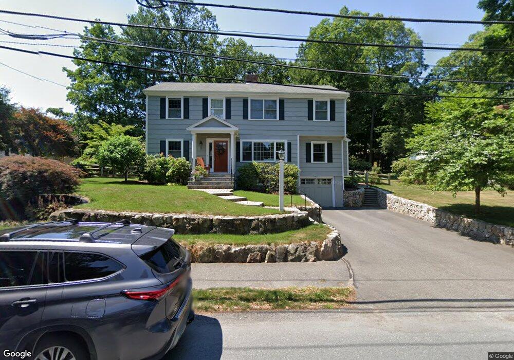
11 Ivy Rd Wellesley, MA 02482
Estimated Value: $1,425,000 - $1,779,357
4
Beds
4
Baths
2,920
Sq Ft
$559/Sq Ft
Est. Value
About This Home
This home is located at 11 Ivy Rd, Wellesley, MA 02482 and is currently estimated at $1,632,839, approximately $559 per square foot. 11 Ivy Rd is a home located in Norfolk County with nearby schools including Sprague Elementary School, Wellesley Middle School, and Wellesley Sr High School.
Ownership History
Date
Name
Owned For
Owner Type
Purchase Details
Closed on
Apr 30, 2002
Sold by
Kilty Mark and Kilty Karen
Bought by
Dupont Pierre E
Current Estimated Value
Purchase Details
Closed on
Oct 25, 2000
Sold by
Almy John W
Bought by
Kilty Mark U and Kilty Karen M
Purchase Details
Closed on
Sep 27, 1993
Sold by
King Mildred L
Bought by
Almy John
Create a Home Valuation Report for This Property
The Home Valuation Report is an in-depth analysis detailing your home's value as well as a comparison with similar homes in the area
Purchase History
| Date | Buyer | Sale Price | Title Company |
|---|---|---|---|
| Dupont Pierre E | $508,000 | -- | |
| Kilty Mark U | $405,000 | -- | |
| Almy John | $235,000 | -- |
Source: Public Records
Mortgage History
| Date | Status | Borrower | Loan Amount |
|---|---|---|---|
| Open | Almy John | $360,000 | |
| Closed | Almy John | $366,000 |
Source: Public Records
Tax History
| Year | Tax Paid | Tax Assessment Tax Assessment Total Assessment is a certain percentage of the fair market value that is determined by local assessors to be the total taxable value of land and additions on the property. | Land | Improvement |
|---|---|---|---|---|
| 2025 | $14,999 | $1,459,000 | $1,013,000 | $446,000 |
| 2024 | $14,074 | $1,352,000 | $921,000 | $431,000 |
| 2023 | $13,832 | $1,208,000 | $816,000 | $392,000 |
| 2022 | $12,720 | $1,089,000 | $701,000 | $388,000 |
| 2021 | $12,114 | $1,031,000 | $670,000 | $361,000 |
| 2020 | $11,918 | $1,031,000 | $670,000 | $361,000 |
| 2019 | $11,582 | $1,001,000 | $640,000 | $361,000 |
| 2018 | $11,771 | $985,000 | $626,000 | $359,000 |
| 2017 | $11,613 | $985,000 | $626,000 | $359,000 |
| 2016 | $11,369 | $961,000 | $616,000 | $345,000 |
| 2015 | $10,739 | $929,000 | $586,000 | $343,000 |
Source: Public Records
Map
Nearby Homes
- 40 Pinewood Rd
- 29 Pinewood Rd
- 63 Oak St Unit B
- 16 Stearns Rd Unit 101
- 16 Stearns Rd Unit 106
- 16 Stearns Rd Unit 103
- 16 Stearns Rd Unit 304
- 16 Stearns Rd Unit 104
- 26B Pleasant St Unit B
- 34 Pleasant St Unit 5
- 25 Mansfield Rd
- 18 Sprague Rd
- 201 Lowell Rd
- 148 Weston Rd Unit 208
- 71 Westgate Rd
- 81 Audubon Rd
- 100 Linden St Unit 111
- 63 Linden St Unit 1
- 63 Linden St Unit 6
- 39 Audubon Rd
Your Personal Tour Guide
Ask me questions while you tour the home.