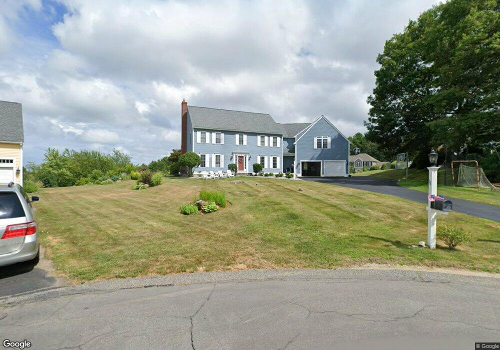
11 Longview Dr Kingston, MA 02364
Estimated Value: $970,000 - $1,149,000
4
Beds
3
Baths
4,182
Sq Ft
$258/Sq Ft
Est. Value
About This Home
This home is located at 11 Longview Dr, Kingston, MA 02364 and is currently estimated at $1,077,444, approximately $257 per square foot. 11 Longview Dr is a home located in Plymouth County with nearby schools including Kingston Elementary School, Silver Lake Regional High School, and Kingston Intermediate School.
Ownership History
Date
Name
Owned For
Owner Type
Purchase Details
Closed on
Mar 26, 2013
Sold by
Rielly Katherine A and Ross Maureen R
Bought by
Geraigery Janet
Current Estimated Value
Home Financials for this Owner
Home Financials are based on the most recent Mortgage that was taken out on this home.
Original Mortgage
$408,000
Outstanding Balance
$281,782
Interest Rate
3%
Mortgage Type
Adjustable Rate Mortgage/ARM
Estimated Equity
$795,662
Purchase Details
Closed on
Nov 17, 2000
Sold by
Fiore Bros Constr Co
Bought by
Parsons Lawrence W
Home Financials for this Owner
Home Financials are based on the most recent Mortgage that was taken out on this home.
Original Mortgage
$360,000
Interest Rate
7.78%
Mortgage Type
Purchase Money Mortgage
Create a Home Valuation Report for This Property
The Home Valuation Report is an in-depth analysis detailing your home's value as well as a comparison with similar homes in the area
Home Values in the Area
Average Home Value in this Area
Purchase History
| Date | Buyer | Sale Price | Title Company |
|---|---|---|---|
| Geraigery Janet | $510,000 | -- | |
| Parsons Lawrence W | $498,484 | -- |
Source: Public Records
Mortgage History
| Date | Status | Borrower | Loan Amount |
|---|---|---|---|
| Open | Geraigery Janet | $408,000 | |
| Previous Owner | Parsons Lawrence W | $65,000 | |
| Previous Owner | Parsons Lawrence W | $425,000 | |
| Previous Owner | Parsons Lawrence W | $398,000 | |
| Previous Owner | Parsons Lawrence W | $360,000 |
Source: Public Records
Tax History Compared to Growth
Tax History
| Year | Tax Paid | Tax Assessment Tax Assessment Total Assessment is a certain percentage of the fair market value that is determined by local assessors to be the total taxable value of land and additions on the property. | Land | Improvement |
|---|---|---|---|---|
| 2025 | $12,119 | $934,412 | $257,012 | $677,400 |
| 2024 | $11,090 | $872,512 | $257,012 | $615,500 |
| 2023 | $10,576 | $791,612 | $257,012 | $534,600 |
| 2022 | $10,146 | $695,905 | $227,805 | $468,100 |
| 2021 | $10,468 | $651,005 | $227,805 | $423,200 |
| 2020 | $10,351 | $635,800 | $227,900 | $407,900 |
| 2019 | $10,131 | $615,500 | $227,900 | $387,600 |
| 2018 | $9,373 | $569,800 | $227,900 | $341,900 |
| 2017 | $9,118 | $552,600 | $203,000 | $349,600 |
| 2016 | $8,930 | $507,100 | $239,800 | $267,300 |
| 2015 | $8,667 | $511,600 | $239,800 | $271,800 |
| 2014 | $8,684 | $520,600 | $243,800 | $276,800 |
Source: Public Records
Map
Nearby Homes
- 20 Orchard Ave
- 35 Sawmill Dr
- 48 Smiths Ln
- 62 Spooner St
- 22 Main St Unit A
- 5-7 Forest Ave
- 393 Court St Unit 4
- 393 Court St Unit 7
- 393 Court St Unit 1
- 4 S Spooner St Unit 6
- 4 S Spooner St Unit 7
- 4 S Spooner St Unit 8
- 2 S Spooner St Unit 3
- 2 S Spooner St Unit 1
- 2 S Spooner St Unit 4
- 17 Howlands Ln
- 94 Main St
- 20-22 Hedge Rd
- 51 Nicks Rock Rd
- 17 Thomas St
- 11 Longview Dr
- 16 Longview Dr
- 72 Ocean Hill Dr
- 79 Ocean Hill Dr
- 7 Longview Dr
- 114 Ocean Hill Dr
- 75 Ocean Hill Dr
- 12 Longview Dr
- 83 Ocean Hill Dr
- 87 Ocean Hill Dr
- 8 Seaview Dr
- 68 Ocean Hill Dr
- 7 Bay Hill Rd
- 11 Bay Hill Rd
- 71 Ocean Hill Dr
- 8 Longview Dr
- 7 Seaview Dr
- 12 Seaview Dr
- 95 Ocean Hill Dr
- 88 Ocean Hill Dr