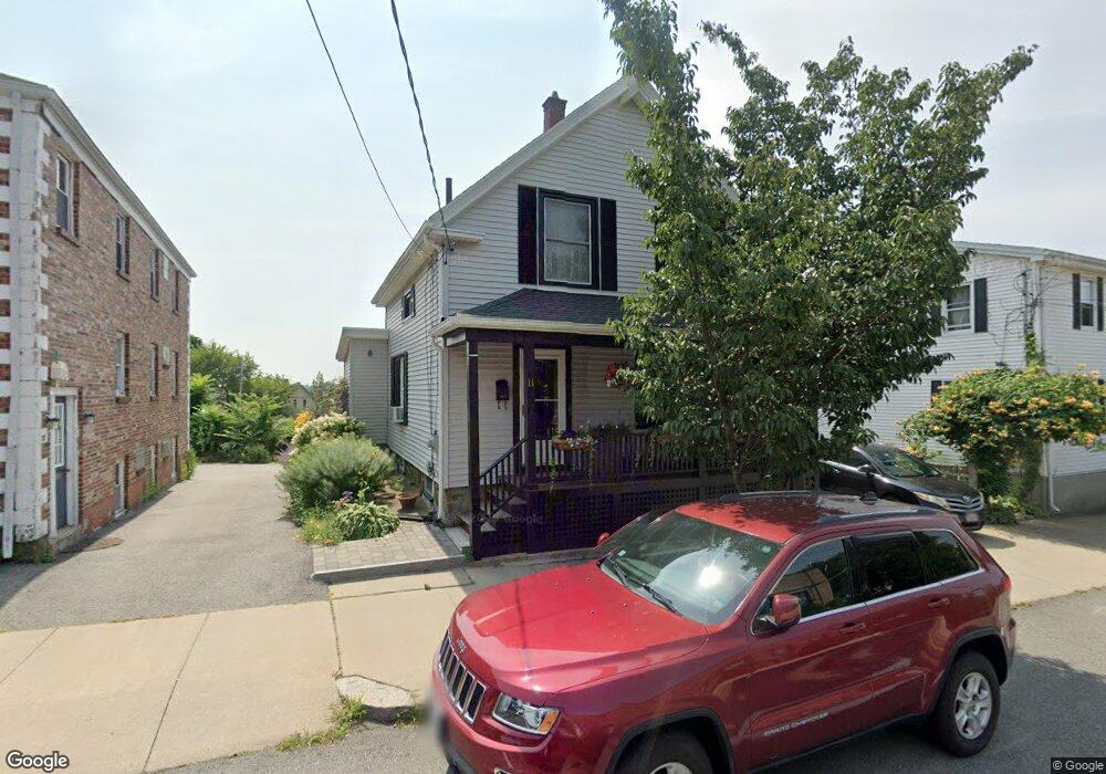
11 Lothrop St Beverly, MA 01915
Downtown Beverly NeighborhoodEstimated Value: $642,881 - $714,000
3
Beds
2
Baths
1,154
Sq Ft
$591/Sq Ft
Est. Value
About This Home
This home is located at 11 Lothrop St, Beverly, MA 01915 and is currently estimated at $681,720, approximately $590 per square foot. 11 Lothrop St is a home located in Essex County with nearby schools including Beverly High School, Mrs Alexander's School, and Harborlight Montessori School.
Ownership History
Date
Name
Owned For
Owner Type
Purchase Details
Closed on
Dec 7, 2023
Sold by
Watson Marie
Bought by
Winddancer11 Irt and Maclean
Current Estimated Value
Purchase Details
Closed on
Mar 29, 1996
Sold by
Ouellet Catalina
Bought by
Watson Kenneth S and Watson Rosemarie
Create a Home Valuation Report for This Property
The Home Valuation Report is an in-depth analysis detailing your home's value as well as a comparison with similar homes in the area
Home Values in the Area
Average Home Value in this Area
Purchase History
| Date | Buyer | Sale Price | Title Company |
|---|---|---|---|
| Winddancer11 Irt | -- | None Available | |
| Watson Kenneth S | $125,000 | -- |
Source: Public Records
Mortgage History
| Date | Status | Borrower | Loan Amount |
|---|---|---|---|
| Previous Owner | Watson Kenneth S | $257,500 | |
| Previous Owner | Watson Kenneth S | $263,000 | |
| Previous Owner | Watson Kenneth S | $100,000 |
Source: Public Records
Tax History
| Year | Tax Paid | Tax Assessment Tax Assessment Total Assessment is a certain percentage of the fair market value that is determined by local assessors to be the total taxable value of land and additions on the property. | Land | Improvement |
|---|---|---|---|---|
| 2025 | $6,252 | $568,900 | $379,200 | $189,700 |
| 2024 | $6,389 | $568,900 | $379,200 | $189,700 |
| 2023 | $6,241 | $554,300 | $364,600 | $189,700 |
| 2022 | $5,637 | $463,200 | $273,500 | $189,700 |
| 2021 | $5,469 | $430,600 | $260,700 | $169,900 |
| 2020 | $4,877 | $380,100 | $210,200 | $169,900 |
| 2019 | $4,450 | $336,900 | $173,300 | $163,600 |
| 2018 | $3,884 | $285,600 | $138,600 | $147,000 |
| 2017 | $3,584 | $251,000 | $104,000 | $147,000 |
| 2016 | $3,612 | $251,000 | $104,000 | $147,000 |
| 2015 | $3,542 | $251,000 | $104,000 | $147,000 |
Source: Public Records
Map
Nearby Homes
- 7 Lothrop St
- 23 1/2 Lovett St
- 24 Franklin Place
- 13 Fayette St Unit 3
- 16 School St Unit 3
- 50 Rantoul St Unit 509S
- 60 Rantoul St Unit 604N
- 60 Rantoul St Unit 114N
- 12 Summit Ave Unit 4
- 40 Railroad Ave Unit B2
- 261 Rantoul St
- 17 Pond St
- The Cabot Collection
- 315 Rantoul St Unit 406
- 34 Chase St
- 348 Rantoul St Unit 202
- 5 Winter Island Rd
- 6 Pilgrim Heights
- 42 Bisson St
- 14 Harrison Ave
- 13 Lothrop St
- 9 Lothrop St Unit 2
- 9 Lothrop St Unit 1
- 15 Lothrop St
- 17 Lothrop St
- 17 Lothrop St Unit 1
- 12 Lothrop St
- 12 Lothrop St Unit 4
- 12 Lothrop St Unit 7
- 12 Lothrop St Unit 6
- 12 Lothrop St Unit 1
- 3 Lothrop St Unit 1
- 3 Lothrop St
- 10 Lothrop St
- 10 Lothrop St Unit 1
- 10 Lothrop St Unit 3
- 6 Silver Ct
- 4 Silver Ct Unit 2
- 4 Silver Ct Unit 1
- 4 Silver Ct
Your Personal Tour Guide
Ask me questions while you tour the home.