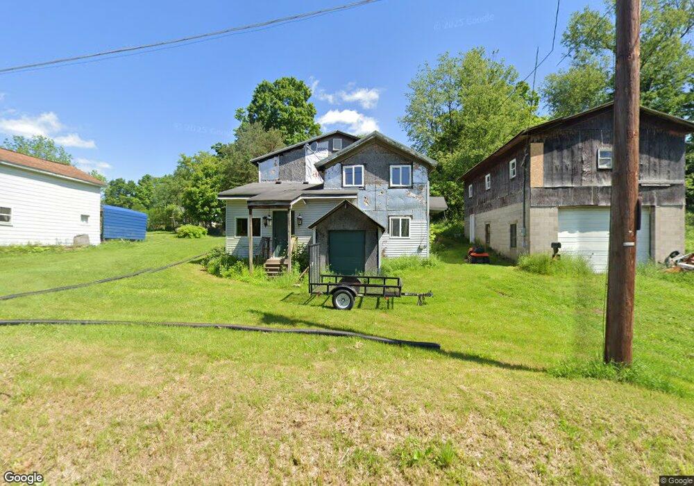
11 Maple St Union City, PA 16438
Estimated Value: $83,000 - $115,357
3
Beds
1
Bath
1,908
Sq Ft
$53/Sq Ft
Est. Value
About This Home
This home is located at 11 Maple St, Union City, PA 16438 and is currently estimated at $101,589, approximately $53 per square foot. 11 Maple St is a home located in Erie County with nearby schools including Union City Elementary School, Union City Middle School, and Union City High School.
Ownership History
Date
Name
Owned For
Owner Type
Purchase Details
Closed on
Nov 2, 2023
Sold by
Erie County Land Bank
Bought by
Kent Gregory and Kent Samantha S
Current Estimated Value
Purchase Details
Closed on
Mar 1, 2023
Sold by
Kent Jason E and Erie County Tax Claim Bureau
Bought by
Erie County Land Bank
Purchase Details
Closed on
May 17, 2018
Sold by
Kent Regina M and Estate Of James N Kent
Bought by
Kent Jason E
Purchase Details
Closed on
Sep 29, 2000
Sold by
Kent Robin L
Bought by
Kent James N
Create a Home Valuation Report for This Property
The Home Valuation Report is an in-depth analysis detailing your home's value as well as a comparison with similar homes in the area
Home Values in the Area
Average Home Value in this Area
Purchase History
| Date | Buyer | Sale Price | Title Company |
|---|---|---|---|
| Kent Gregory | $10,000 | None Listed On Document | |
| Erie County Land Bank | -- | None Listed On Document | |
| Kent Jason E | -- | None Available | |
| Kent James N | -- | -- |
Source: Public Records
Tax History Compared to Growth
Tax History
| Year | Tax Paid | Tax Assessment Tax Assessment Total Assessment is a certain percentage of the fair market value that is determined by local assessors to be the total taxable value of land and additions on the property. | Land | Improvement |
|---|---|---|---|---|
| 2025 | $960 | $33,800 | $11,300 | $22,500 |
| 2024 | $960 | $33,800 | $11,300 | $22,500 |
| 2023 | $899 | $33,800 | $11,300 | $22,500 |
| 2022 | $889 | $33,800 | $11,300 | $22,500 |
| 2021 | $898 | $33,800 | $11,300 | $22,500 |
| 2020 | $851 | $33,800 | $11,300 | $22,500 |
| 2019 | $845 | $33,800 | $11,300 | $22,500 |
| 2018 | $839 | $33,800 | $11,300 | $22,500 |
| 2017 | $826 | $33,800 | $11,300 | $22,500 |
| 2016 | $900 | $33,800 | $11,300 | $22,500 |
| 2015 | $892 | $33,800 | $11,300 | $22,500 |
| 2014 | $538 | $33,800 | $11,300 | $22,500 |
Source: Public Records
Map
Nearby Homes
- 92 S Main St
- 108 S Main St
- Lot 1 Dobbs Rd
- LOT 4 Danner Dr & Lot 15 Linda Ln
- LOT 3 Danner Dr & Lot 14 Linda Ln
- LOT 1 Danner Dr & Lot 12 Linda Ln
- LOT 2 & 13 Danner Dr & Linda Ln
- 23 Center St
- 139 S Main St
- 15900 Wattsburg-Union Rd
- 10500 U S 6
- 11097 Route 6
- 11111 Nash Hill Rd
- 11320 Nash Hill Rd
- 26215 Shreve Ridge Rd
- 0 Stewart Hill Rd
- 3920 Stone Quarry Rd
- Lot 614 637 638 Weed Rd
- Lot 614, 637, & 638 Weed Rd
- 35979 Birch Ave