Estimated Value: $683,000 - $897,000
3
Beds
4
Baths
1,700
Sq Ft
$462/Sq Ft
Est. Value
About This Home
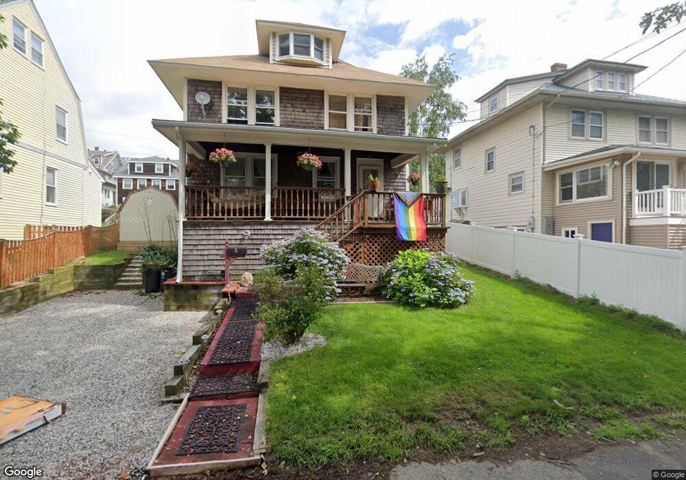
This home is located at 11 Mayflower Rd Unit 1, Hull, MA 02045 and is currently estimated at $785,856, approximately $462 per square foot. 11 Mayflower Rd Unit 1 is a home located in Plymouth County with nearby schools including Lillian M. Jacobs Elementary School, Memorial Middle School, and Hull High School.
Ownership History
Date
Name
Owned For
Owner Type
Purchase Details
Closed on
Jul 6, 2009
Sold by
Plotkin Stephen L and Plotkin Sherry A
Bought by
Stephen and Stephen Sherry Plotkin
Current Estimated Value
Home Financials for this Owner
Home Financials are based on the most recent Mortgage that was taken out on this home.
Original Mortgage
$295,000
Outstanding Balance
$183,256
Interest Rate
4.86%
Mortgage Type
Purchase Money Mortgage
Estimated Equity
$602,600
Purchase Details
Closed on
Jul 26, 2007
Sold by
Plotkin Stephen L and Plotkin Sherry A
Bought by
S L & S Plotkin Ret and Plotkin
Purchase Details
Closed on
Aug 1, 2003
Sold by
Saayfan Paula E
Bought by
Plotkin Stephen L and Plotkin Sherry A
Purchase Details
Closed on
May 31, 2000
Sold by
Micherone Anthony and Micherone Dianne E
Bought by
Mcleod Scott M and Mcleod Kelli L
Purchase Details
Closed on
Jan 29, 1996
Sold by
Langlands Robert and Langlands Frances
Bought by
Saayfan Paula E
Create a Home Valuation Report for This Property
The Home Valuation Report is an in-depth analysis detailing your home's value as well as a comparison with similar homes in the area
Purchase History
| Date | Buyer | Sale Price | Title Company |
|---|---|---|---|
| Stephen | -- | -- | |
| Plotkin Stephen L | -- | -- | |
| S L & S Plotkin Ret | -- | -- | |
| Plotkin Stephen L | $400,000 | -- | |
| Mcleod Scott M | $175,000 | -- | |
| Saayfan Paula E | $119,000 | -- |
Source: Public Records
Mortgage History
| Date | Status | Borrower | Loan Amount |
|---|---|---|---|
| Open | Saayfan Paula E | $295,000 | |
| Closed | Saayfan Paula E | $295,000 |
Source: Public Records
Tax History
| Year | Tax Paid | Tax Assessment Tax Assessment Total Assessment is a certain percentage of the fair market value that is determined by local assessors to be the total taxable value of land and additions on the property. | Land | Improvement |
|---|---|---|---|---|
| 2025 | $6,960 | $621,400 | $208,000 | $413,400 |
| 2024 | $6,919 | $593,900 | $201,500 | $392,400 |
| 2023 | $6,909 | $567,700 | $195,000 | $372,700 |
| 2022 | $6,749 | $538,200 | $182,000 | $356,200 |
| 2021 | $6,505 | $513,000 | $162,500 | $350,500 |
| 2020 | $6,102 | $476,000 | $162,500 | $313,500 |
| 2019 | $5,990 | $459,000 | $156,000 | $303,000 |
| 2018 | $4,232 | $417,300 | $156,000 | $261,300 |
| 2017 | $5,439 | $396,400 | $156,000 | $240,400 |
| 2016 | $5,168 | $383,400 | $143,000 | $240,400 |
| 2015 | $5,140 | $368,700 | $130,000 | $238,700 |
| 2014 | $5,114 | $368,700 | $130,000 | $238,700 |
Source: Public Records
Map
Nearby Homes
- 11 Mayflower Rd
- 11 Mayflower Rd Unit 2/06-6/15
- 11 Mayflower Rd Unit 1/02-6/15
- 11 Mayflower Rd Unit 1
- 11 Mayflower Rd Winter Rntl Unit 10/18-6/15
- 11 Mayflower Rd Winter Rntl Unit 9/1-6/15
- 13 Mayflower Rd
- 9 Mayflower Rd
- 15 Mayflower Rd
- 14 Mayflower Rd
- 6 Mayflower Rd
- 8 Beacon Rd
- 11 Bradford Ave
- 6 Beacon Rd
- 15 Bradford Ave
- 18 Mayflower Rd
- 9 Bradford Ave
- 22 Mayflower Rd
- 17 Bradford Ave
- 7 Bradford Ave
Your Personal Tour Guide
Ask me questions while you tour the home.