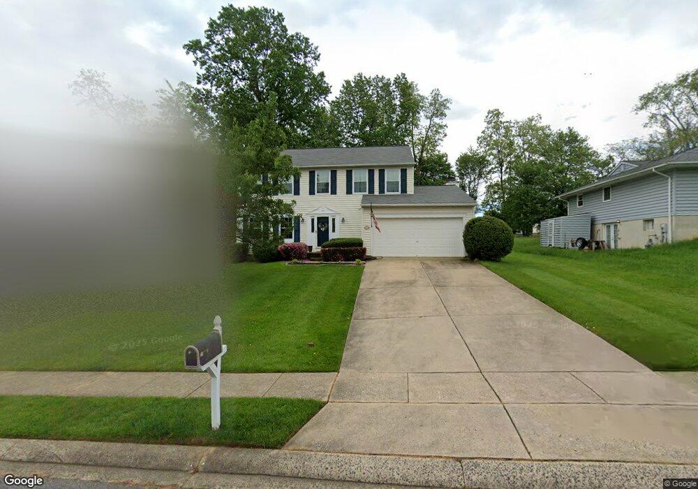
11 Mitchell Dr Abingdon, MD 21009
Estimated Value: $466,000 - $526,000
4
Beds
3
Baths
2,032
Sq Ft
$240/Sq Ft
Est. Value
About This Home
This home is located at 11 Mitchell Dr, Abingdon, MD 21009 and is currently estimated at $488,396, approximately $240 per square foot. 11 Mitchell Dr is a home located in Harford County with nearby schools including William S. James Elementary School, Patterson Mill Middle School, and Patterson Mill High School.
Ownership History
Date
Name
Owned For
Owner Type
Purchase Details
Closed on
Mar 23, 2023
Sold by
Brown Martin David
Bought by
Brown Tricia Marie
Current Estimated Value
Purchase Details
Closed on
Jun 6, 2008
Sold by
Wolf Martin E
Bought by
Brown Martin David and Brown Tricia Marie
Home Financials for this Owner
Home Financials are based on the most recent Mortgage that was taken out on this home.
Original Mortgage
$362,950
Interest Rate
5.91%
Mortgage Type
Purchase Money Mortgage
Purchase Details
Closed on
May 19, 2008
Sold by
Wolf Martin E
Bought by
Brown Martin David and Brown Tricia Marie
Home Financials for this Owner
Home Financials are based on the most recent Mortgage that was taken out on this home.
Original Mortgage
$362,950
Interest Rate
5.91%
Mortgage Type
Purchase Money Mortgage
Create a Home Valuation Report for This Property
The Home Valuation Report is an in-depth analysis detailing your home's value as well as a comparison with similar homes in the area
Home Values in the Area
Average Home Value in this Area
Purchase History
| Date | Buyer | Sale Price | Title Company |
|---|---|---|---|
| Brown Tricia Marie | -- | -- | |
| Brown Martin David | $382,102 | -- | |
| Brown Martin David | $382,102 | -- |
Source: Public Records
Mortgage History
| Date | Status | Borrower | Loan Amount |
|---|---|---|---|
| Previous Owner | Brown Martin David | $362,950 | |
| Previous Owner | Brown Martin David | $362,950 |
Source: Public Records
Tax History Compared to Growth
Tax History
| Year | Tax Paid | Tax Assessment Tax Assessment Total Assessment is a certain percentage of the fair market value that is determined by local assessors to be the total taxable value of land and additions on the property. | Land | Improvement |
|---|---|---|---|---|
| 2025 | $3,523 | $350,600 | $0 | $0 |
| 2024 | $3,523 | $328,900 | $0 | $0 |
| 2023 | $3,348 | $307,200 | $83,400 | $223,800 |
| 2022 | $3,254 | $298,533 | $0 | $0 |
| 2021 | $3,245 | $289,867 | $0 | $0 |
| 2020 | $3,245 | $281,200 | $83,400 | $197,800 |
| 2019 | $3,169 | $274,567 | $0 | $0 |
| 2018 | $3,064 | $267,933 | $0 | $0 |
| 2017 | $2,988 | $261,300 | $0 | $0 |
| 2016 | $140 | $258,467 | $0 | $0 |
| 2015 | $3,542 | $255,633 | $0 | $0 |
| 2014 | $3,542 | $252,800 | $0 | $0 |
Source: Public Records
Map
Nearby Homes
- 2902 Preston Ln
- 2608 Laurel Valley Garth
- 2921 Shelley Ct
- 2543 Merrick Ct
- 104 Singer Rd
- 108 Laurel Valley Ct
- 201 Oak Leaf Cir Unit L
- 3109 Eden Dr
- 2961 Harrogate Way
- 3026 Cascade Dr
- 3110 Woodspring Dr
- 741 Burgh Westra Way
- 221 Glen View Terrace
- 3300 Woodspring Dr
- 422 Clydebank Dr
- 3146 Tipton Way
- 745 Dowers Rd
- 2815 Lanarkshire Way
- 211 E Wheel Rd
- 3110 Tipton Way