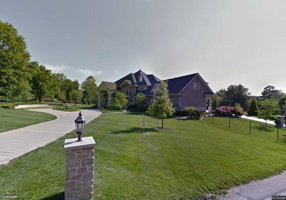
11 Old Colony Ln Saint Louis, MO 63131
Estimated Value: $3,097,319 - $4,692,000
5
Beds
8
Baths
12,761
Sq Ft
$296/Sq Ft
Est. Value
About This Home
This home is located at 11 Old Colony Ln, Saint Louis, MO 63131 and is currently estimated at $3,772,773, approximately $295 per square foot. 11 Old Colony Ln is a home located in St. Louis County with nearby schools including Mason Ridge Elementary School, Parkway West Middle School, and Parkway West High School.
Ownership History
Date
Name
Owned For
Owner Type
Purchase Details
Closed on
Mar 12, 2009
Sold by
Greene Robert P and Greene Wendy Y
Bought by
Amir Hossain Tajkarimi Living Trust and Tajkarimi Amir Hossain
Current Estimated Value
Home Financials for this Owner
Home Financials are based on the most recent Mortgage that was taken out on this home.
Original Mortgage
$2,000,000
Outstanding Balance
$1,304,394
Interest Rate
5.62%
Mortgage Type
Purchase Money Mortgage
Estimated Equity
$2,468,379
Purchase Details
Closed on
Jul 15, 2004
Sold by
Hagedorn John Leo and Hagedorn Kathy G
Bought by
Greene Robert P and Greene Wendy Y
Home Financials for this Owner
Home Financials are based on the most recent Mortgage that was taken out on this home.
Original Mortgage
$620,000
Interest Rate
6%
Mortgage Type
Purchase Money Mortgage
Create a Home Valuation Report for This Property
The Home Valuation Report is an in-depth analysis detailing your home's value as well as a comparison with similar homes in the area
Home Values in the Area
Average Home Value in this Area
Purchase History
| Date | Buyer | Sale Price | Title Company |
|---|---|---|---|
| Amir Hossain Tajkarimi Living Trust | $5,300,000 | Title Partners Agency Llc | |
| Greene Robert P | $820,000 | -- |
Source: Public Records
Mortgage History
| Date | Status | Borrower | Loan Amount |
|---|---|---|---|
| Open | Amir Hossain Tajkarimi Living Trust | $2,000,000 | |
| Previous Owner | Greene Robert P | $620,000 |
Source: Public Records
Tax History Compared to Growth
Tax History
| Year | Tax Paid | Tax Assessment Tax Assessment Total Assessment is a certain percentage of the fair market value that is determined by local assessors to be the total taxable value of land and additions on the property. | Land | Improvement |
|---|---|---|---|---|
| 2025 | $44,212 | $760,000 | $109,230 | $650,770 |
| 2024 | $44,212 | $760,000 | $97,090 | $662,910 |
| 2023 | $41,842 | $760,000 | $97,090 | $662,910 |
| 2022 | $35,196 | $580,940 | $109,230 | $471,710 |
| 2021 | $34,903 | $580,940 | $109,230 | $471,710 |
| 2020 | $40,135 | $638,750 | $97,380 | $541,370 |
| 2019 | $39,571 | $638,750 | $97,380 | $541,370 |
| 2018 | $43,927 | $655,500 | $86,560 | $568,940 |
| 2017 | $43,331 | $655,500 | $86,560 | $568,940 |
| 2016 | $45,582 | $655,500 | $75,750 | $579,750 |
| 2015 | $48,046 | $655,500 | $75,750 | $579,750 |
| 2014 | $54,420 | $806,510 | $36,860 | $769,650 |
Source: Public Records
Map
Nearby Homes
- 1824 Topping Rd
- 1515 Topping Rd
- 12841 Thornhill Ct
- 1652 Mason Knoll Rd
- 12439 Springdale Ln Unit TBB
- 13354 Thornhill Dr
- 1473 Mason Valley Rd
- 2211 Viewroyal Dr
- 29a Chapel Hill Estates Dr
- 831 Minarca Dr
- 1536 S Mason Rd
- The Hawthorne Plan at Ballas Ridge
- The Roclare II Plan at Ballas Ridge
- The Westchester IV Plan at Ballas Ridge
- The Nottingham II Plan at Ballas Ridge
- The Hawthorne II Plan at Ballas Ridge
- 2056 N Ballas Rd
- 2062 N Ballas Rd
- TBB
- TBB Ballas Ridge Roclare II
- 1739 Topping Rd
- 1623 Topping Rd
- 10 Brookwood Rd
- 1610 Kriste Ct
- 1738 Topping Rd
- 1745 Topping Rd
- 1730 Topping Rd
- 12914 Woodlark Ln
- 12920 Woodlark Ln
- 12900 Woodlark Ln
- 1744 Topping Rd
- 1761 Topping Rd
- 1757 Topping Rd
- 9 Brookwood Rd
- 12856 Topping Acres St
- 1756 Topping Rd
- 12921 Woodlark Ln
- 12915 Woodlark Ln
- 12940 Woodlark Ln
- 12855 Topping Acres