
Seller's Agent in 2025
Kristin Nemec
William Pitt
(203) 829-8998
26 in this area
37 Total Sales
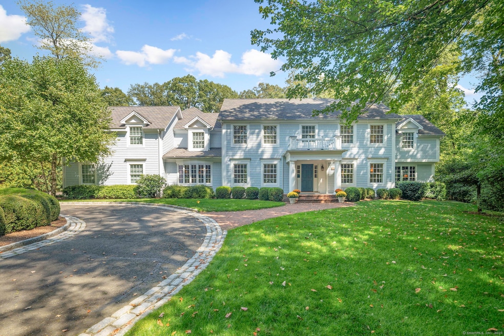
Nestled on a quiet cul-de-sac in the Boulder Ridge Association, 11 Old Oak Road is a timeless 5-bedroom, 5.5-bathroom colonial that offers the perfect blend of classic elegance and modern comfort. Step inside and you'll be greeted by spacious, sun-filled rooms that make this home ideal for both everyday living and elegant entertaining. The formal dining room, living room, sitting room, study, and butler's pantry add to the home's refined charm-but the heart of the house is truly exceptional. The chef's kitchen-featuring top-of-the-line appliances, custom cabinetry, and a large center island-flows seamlessly into the expansive family room, where a soaring cathedral ceiling, wood-burning fireplace, and French doors open onto the terrace and the pool beyond, creating an effortless indoor-outdoor lifestyle. Upstairs, the primary suite serves as a private retreat, complete with a balcony, office, two walk-in closets, and a spa-like bathroom with dual vanities and lavatories, soaking tub, and a separate steam shower. An additional 1,000-square-foot finished basement with a full bathroom provides flexible space for a home gym, media room, or guest accommodations-and the three-car garage is a welcome bonus. Residents of Boulder Ridge enjoy access to Boulder Ridge Park, which includes a playground and tennis court. Located in a peaceful, private setting just minutes from Darien's top-rated schools, shopping, dining, and the train, this special property offers the best of both worlds.
Last Agent to Sell the Property
William Pitt Sotheby's Int'l Brokerage Phone: (203) 829-8998 License #REB.0795032 Listed on: 09/23/2025
| Date | Type | Sale Price | Title Company |
|---|---|---|---|
| Warranty Deed | $4,425,000 | -- | |
| Warranty Deed | $4,425,000 | -- | |
| Warranty Deed | $2,800,000 | -- | |
| Warranty Deed | $1,254,500 | -- | |
| Warranty Deed | $845,000 | -- |
| Date | Status | Loan Amount | Loan Type |
|---|---|---|---|
| Open | $3,000,000 | New Conventional | |
| Closed | $3,000,000 | New Conventional | |
| Previous Owner | $2,560,000 | Stand Alone Refi Refinance Of Original Loan | |
| Previous Owner | $697,000 | No Value Available |
| Date | Event | Price | List to Sale | Price per Sq Ft |
|---|---|---|---|---|
| 12/18/2025 12/18/25 | Sold | $4,425,000 | +13.6% | $495 / Sq Ft |
| 10/14/2025 10/14/25 | Pending | -- | -- | -- |
| 10/02/2025 10/02/25 | For Sale | $3,895,000 | -- | $436 / Sq Ft |
| Year | Tax Paid | Tax Assessment Tax Assessment Total Assessment is a certain percentage of the fair market value that is determined by local assessors to be the total taxable value of land and additions on the property. | Land | Improvement |
|---|---|---|---|---|
| 2025 | $40,306 | $2,603,720 | $748,230 | $1,855,490 |
| 2024 | $38,249 | $2,603,720 | $748,230 | $1,855,490 |
| 2023 | $33,071 | $1,877,960 | $498,820 | $1,379,140 |
| 2022 | $32,357 | $1,877,960 | $498,820 | $1,379,140 |
| 2021 | $11,820 | $1,877,960 | $498,820 | $1,379,140 |
| 2020 | $30,699 | $1,876,490 | $497,350 | $1,379,140 |
| 2019 | $30,906 | $1,876,490 | $497,350 | $1,379,140 |
| 2018 | $31,484 | $1,957,970 | $532,910 | $1,425,060 |
| 2017 | $9,530 | $1,957,970 | $532,910 | $1,425,060 |
| 2016 | $30,877 | $1,957,970 | $532,910 | $1,425,060 |
| 2015 | $30,055 | $1,957,970 | $532,910 | $1,425,060 |
| 2014 | $29,389 | $1,957,970 | $532,910 | $1,425,060 |
Seller's Agent in 2025
Kristin Nemec
William Pitt
(203) 829-8998
26 in this area
37 Total Sales
Buyer's Agent in 2025
Janine Tienken
Houlihan Lawrence
(203) 246-7518
91 in this area
115 Total Sales
R
Buyer Co-Listing Agent in 2025
Rita Marber
Houlihan Lawrence
(203) 249-4537
5 in this area
10 Total Sales
Source: SmartMLS
MLS Number: 24126582
APN: DARI-000008-000000-000005
Disclaimer: Certain information contained herein is derived from information provided by parties other than Homes.com. All information provided is deemed reliable, but is not guaranteed to be accurate and should be independently verified.
![]() IDX information is provided exclusively for personal, non-commercial use, and may not be used for any purpose other than to identify prospective properties consumers may be interested in purchasing. Information is deemed reliable but not guaranteed.
IDX information is provided exclusively for personal, non-commercial use, and may not be used for any purpose other than to identify prospective properties consumers may be interested in purchasing. Information is deemed reliable but not guaranteed.
Ask me questions while you tour the home.