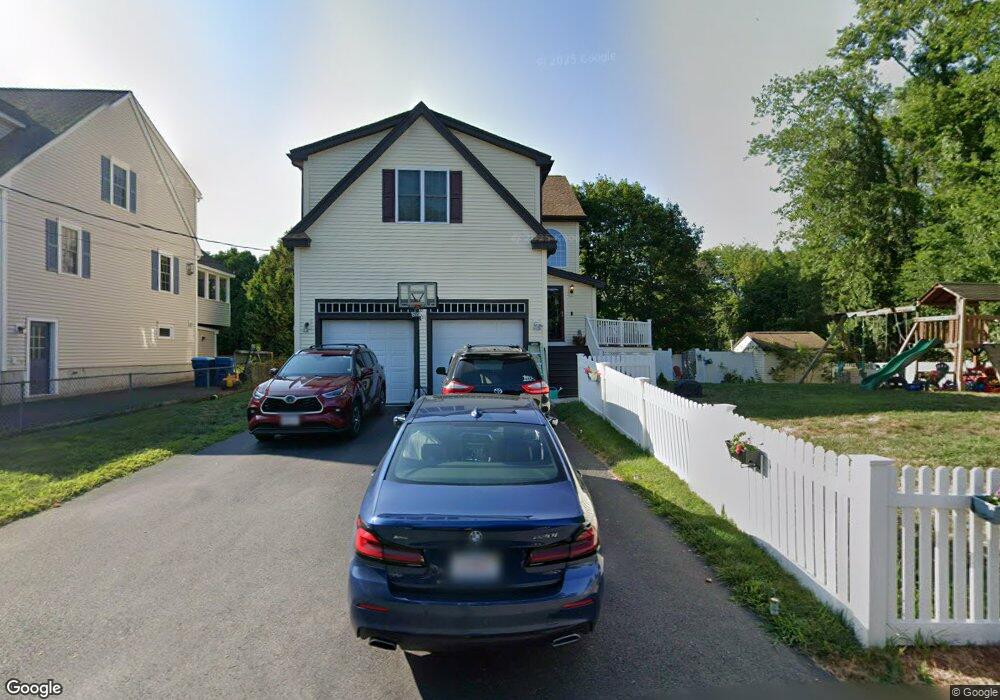
11 Orchid Dr Unit n/a Littleton, MA 01460
Littleton Common NeighborhoodEstimated Value: $916,000 - $1,016,000
3
Beds
2
Baths
1,696
Sq Ft
$569/Sq Ft
Est. Value
About This Home
This home is located at 11 Orchid Dr Unit n/a, Littleton, MA 01460 and is currently estimated at $965,131, approximately $569 per square foot. 11 Orchid Dr Unit n/a is a home located in Middlesex County with nearby schools including Shaker Lane Elementary School, Russell Street Elementary School, and Littleton Middle School.
Ownership History
Date
Name
Owned For
Owner Type
Purchase Details
Closed on
Jan 7, 2014
Sold by
83-85 Summer Street Rt
Bought by
Kraft Matthew S and Kraft Stephanie N
Current Estimated Value
Home Financials for this Owner
Home Financials are based on the most recent Mortgage that was taken out on this home.
Original Mortgage
$192,000
Outstanding Balance
$144,111
Interest Rate
4.24%
Mortgage Type
New Conventional
Estimated Equity
$821,020
Purchase Details
Closed on
May 31, 2013
Sold by
11 Orchid Drive Rt and Bentas Anne C
Bought by
83-85 Summer Street Rt and King Frank M
Purchase Details
Closed on
Apr 12, 2013
Sold by
Bright Peter A
Bought by
11 Orchid Drive Rt
Create a Home Valuation Report for This Property
The Home Valuation Report is an in-depth analysis detailing your home's value as well as a comparison with similar homes in the area
Home Values in the Area
Average Home Value in this Area
Purchase History
| Date | Buyer | Sale Price | Title Company |
|---|---|---|---|
| Kraft Matthew S | $505,000 | -- | |
| 83-85 Summer Street Rt | $307,500 | -- | |
| 11 Orchid Drive Rt | $336,659 | -- |
Source: Public Records
Mortgage History
| Date | Status | Borrower | Loan Amount |
|---|---|---|---|
| Open | Kraft Matthew S | $192,000 | |
| Previous Owner | Kraft Matthew S | $170,000 | |
| Previous Owner | Kraft Matthew S | $121,345 |
Source: Public Records
Tax History Compared to Growth
Tax History
| Year | Tax Paid | Tax Assessment Tax Assessment Total Assessment is a certain percentage of the fair market value that is determined by local assessors to be the total taxable value of land and additions on the property. | Land | Improvement |
|---|---|---|---|---|
| 2025 | $112 | $756,900 | $202,700 | $554,200 |
| 2024 | $10,965 | $738,900 | $202,700 | $536,200 |
| 2023 | $10,699 | $658,400 | $187,900 | $470,500 |
| 2022 | $9,926 | $560,500 | $180,600 | $379,900 |
| 2021 | $9,714 | $548,800 | $175,000 | $373,800 |
| 2020 | $9,493 | $534,200 | $150,700 | $383,500 |
| 2019 | $9,454 | $518,300 | $130,600 | $387,700 |
| 2018 | $9,300 | $512,700 | $130,600 | $382,100 |
| 2017 | $9,184 | $506,000 | $123,900 | $382,100 |
| 2016 | $8,898 | $503,000 | $123,900 | $379,100 |
| 2015 | $8,342 | $460,900 | $107,200 | $353,700 |
Source: Public Records
Map
Nearby Homes
- 4 Mars Place
- 115 Goldsmith St
- 55 Jennifer St
- 12 Paula Beth St
- 34 Baldwin Hill Rd
- 8 Edsel Rd
- 10 Baldwin Hill Rd
- 16 Fletcher Ln
- 18 Long Lake Rd
- 336 King St Unit 105
- 35 Queen Rd
- 146 Tahattawan Rd
- 17 Hartwell Ave
- 305 Harwood Ave
- 84 Powers Rd
- 5 Mill Park Place
- 5 Mill Park Place Unit 5
- 3 Mill Park Place
- 3 Mill Park Place Unit 3
- 18 Pleasant St