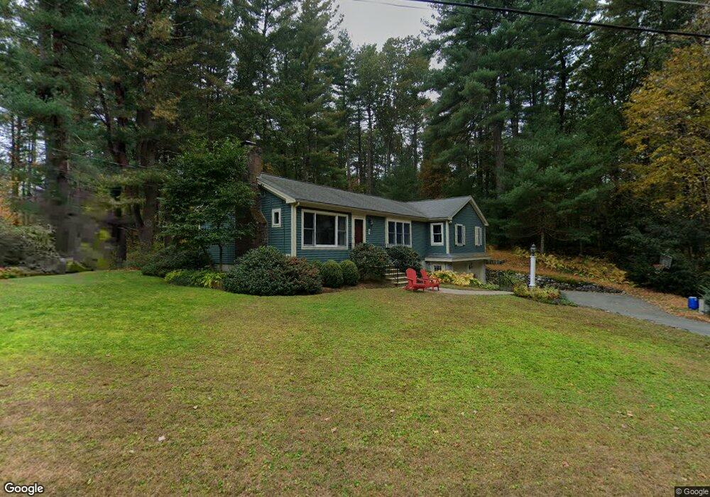
11 Peakham Cir Sudbury, MA 01776
Estimated Value: $875,000 - $972,000
3
Beds
2
Baths
1,850
Sq Ft
$491/Sq Ft
Est. Value
About This Home
This home is located at 11 Peakham Cir, Sudbury, MA 01776 and is currently estimated at $907,759, approximately $490 per square foot. 11 Peakham Cir is a home located in Middlesex County with nearby schools including Peter Noyes Elementary School, Ephraim Curtis Middle School, and Lincoln-Sudbury Regional High School.
Ownership History
Date
Name
Owned For
Owner Type
Purchase Details
Closed on
Jun 15, 1998
Sold by
Craig William N and Craig Gertrude S
Bought by
Cincotta Mark A and Cincotta Cynthia M
Current Estimated Value
Home Financials for this Owner
Home Financials are based on the most recent Mortgage that was taken out on this home.
Original Mortgage
$184,000
Interest Rate
7.11%
Mortgage Type
Purchase Money Mortgage
Create a Home Valuation Report for This Property
The Home Valuation Report is an in-depth analysis detailing your home's value as well as a comparison with similar homes in the area
Home Values in the Area
Average Home Value in this Area
Purchase History
| Date | Buyer | Sale Price | Title Company |
|---|---|---|---|
| Cincotta Mark A | $230,000 | -- |
Source: Public Records
Mortgage History
| Date | Status | Borrower | Loan Amount |
|---|---|---|---|
| Open | Cincotta Mark A | $143,000 | |
| Closed | Cincotta Mark A | $20,000 | |
| Closed | Cincotta Mark A | $184,000 |
Source: Public Records
Tax History Compared to Growth
Tax History
| Year | Tax Paid | Tax Assessment Tax Assessment Total Assessment is a certain percentage of the fair market value that is determined by local assessors to be the total taxable value of land and additions on the property. | Land | Improvement |
|---|---|---|---|---|
| 2025 | $10,951 | $748,000 | $403,600 | $344,400 |
| 2024 | $10,560 | $722,800 | $391,800 | $331,000 |
| 2023 | $10,653 | $675,500 | $362,800 | $312,700 |
| 2022 | $10,301 | $570,700 | $333,000 | $237,700 |
| 2021 | $10,161 | $539,600 | $333,000 | $206,600 |
| 2020 | $9,956 | $539,600 | $333,000 | $206,600 |
| 2019 | $9,664 | $539,600 | $333,000 | $206,600 |
| 2018 | $9,085 | $506,700 | $355,000 | $151,700 |
| 2017 | $8,357 | $471,100 | $337,700 | $133,400 |
| 2016 | $8,060 | $452,800 | $324,900 | $127,900 |
| 2015 | $7,394 | $420,100 | $312,400 | $107,700 |
| 2014 | $7,376 | $409,100 | $303,200 | $105,900 |
Source: Public Records
Map
Nearby Homes
- 270 Old Lancaster Rd
- 89 Bridle Path
- 24 Goodnow Rd
- 25 Bridle Path
- 36 Concord Rd
- 427 Concord Rd
- 36 Old Forge Ln
- 23 Massasoit Ave
- 7 Saddle Ridge Rd
- 1011 Boston Post Rd
- 14 Tanbark Rd
- 94 Goodmans Hill Rd
- 30 Rolling Ln
- 12 Hickory Rd
- 0 Robbins Rd
- 24 Woodland Rd
- 54 Stone Rd
- 12 Camperdown Ln
- 63 Canterbury Dr
- 4 Elderberry Cir
- 20 Peakham Cir
- 5 Peakham Cir
- 12 Peakham Cir
- 534 Peakham Rd
- 10 Candlewood Cir
- 2 Candlewood Cir
- 541 Peakham Rd
- 546 Peakham Rd
- 17 Peakham Cir
- 531 Peakham Rd
- 527 Peakham Rd
- 15 Candlewood Cir
- 554 Peakham Rd
- 5 Homestead St
- 4 Homestead St
- 560 Peakham Rd
- 11 Candlewood Cir
- 5 Candlewood Cir
- 521 Peakham Rd
- 248 Old Lancaster Rd