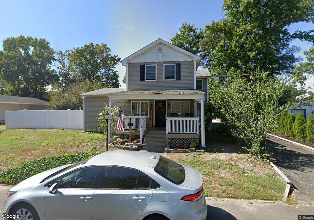
11 Pinewood Ave Keansburg, NJ 07734
Estimated Value: $546,000 - $665,000
4
Beds
2
Baths
2,052
Sq Ft
$298/Sq Ft
Est. Value
About This Home
This home is located at 11 Pinewood Ave, Keansburg, NJ 07734 and is currently estimated at $612,119, approximately $298 per square foot. 11 Pinewood Ave is a home located in Monmouth County with nearby schools including Raritan High School, Baytul-Iman Academy, and St. Ann School.
Ownership History
Date
Name
Owned For
Owner Type
Purchase Details
Closed on
Aug 29, 2014
Sold by
Deangelo Michael and Deangelo Mary E
Bought by
Everett Danielle E and Cangelosi Samantha
Current Estimated Value
Home Financials for this Owner
Home Financials are based on the most recent Mortgage that was taken out on this home.
Original Mortgage
$314,204
Outstanding Balance
$211,409
Interest Rate
3.87%
Mortgage Type
FHA
Estimated Equity
$400,710
Create a Home Valuation Report for This Property
The Home Valuation Report is an in-depth analysis detailing your home's value as well as a comparison with similar homes in the area
Home Values in the Area
Average Home Value in this Area
Purchase History
| Date | Buyer | Sale Price | Title Company |
|---|---|---|---|
| Everett Danielle E | $320,000 | None Available |
Source: Public Records
Mortgage History
| Date | Status | Borrower | Loan Amount |
|---|---|---|---|
| Open | Everett Danielle E | $314,204 |
Source: Public Records
Tax History Compared to Growth
Tax History
| Year | Tax Paid | Tax Assessment Tax Assessment Total Assessment is a certain percentage of the fair market value that is determined by local assessors to be the total taxable value of land and additions on the property. | Land | Improvement |
|---|---|---|---|---|
| 2025 | $11,137 | $561,600 | $240,100 | $321,500 |
| 2024 | $11,125 | $529,600 | $209,500 | $320,100 |
| 2023 | $11,125 | $520,600 | $199,600 | $321,000 |
| 2022 | $10,119 | $432,800 | $180,300 | $252,500 |
| 2021 | $10,119 | $376,900 | $168,800 | $208,100 |
| 2020 | $9,512 | $368,400 | $164,800 | $203,600 |
| 2019 | $9,293 | $354,300 | $151,800 | $202,500 |
| 2018 | $9,001 | $340,300 | $146,800 | $193,500 |
| 2017 | $8,636 | $326,500 | $138,500 | $188,000 |
| 2016 | $8,440 | $320,300 | $138,500 | $181,800 |
| 2015 | $8,294 | $315,600 | $138,500 | $177,100 |
| 2014 | $7,599 | $271,200 | $116,800 | $154,400 |
Source: Public Records
Map
Nearby Homes
- 55 11th St
- 45 8th St
- 115 10th St
- 115 10th St Unit 11-113
- 158 9th St
- 21 13th St
- 261 State Route 36
- 0 Munro Ave
- 177 Creek Rd
- 5 Justin Ct Unit 96
- 5 Justin Ct
- 330 State Route 36
- 34 Randall Ave Unit 67
- 32 Randall Ave Unit 65
- 30 Randall Ave Unit 63
- 101 Manning Place
- 79 Central Ave
- 1 Robin Rd
- 46 Randall Ave
- 35 Randall Ave Unit 68