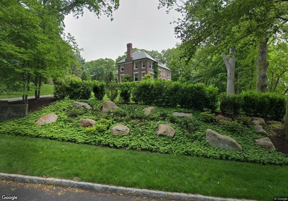
11 Ridge Rd Summit, NJ 07901
Estimated Value: $4,689,932 - $5,454,000
8
Beds
10
Baths
10,000
Sq Ft
$519/Sq Ft
Est. Value
About This Home
This home is located at 11 Ridge Rd, Summit, NJ 07901 and is currently estimated at $5,189,977, approximately $518 per square foot. 11 Ridge Rd is a home located in Union County with nearby schools including L C Johnson Summit Middle School, Summit Sr High School, and Kent Place School.
Ownership History
Date
Name
Owned For
Owner Type
Purchase Details
Closed on
Oct 27, 2020
Sold by
France Mary F and Rutter Mary T
Bought by
The France Family Revocable Trust
Current Estimated Value
Purchase Details
Closed on
Mar 2, 2020
Sold by
Rutter David and Rutter Mary
Bought by
Rutter Mary T
Purchase Details
Closed on
Sep 4, 2007
Sold by
Anderson Erika R and Hayes John
Bought by
Rutter David and Rutter Mary
Home Financials for this Owner
Home Financials are based on the most recent Mortgage that was taken out on this home.
Original Mortgage
$4,225,500
Outstanding Balance
$2,577,752
Interest Rate
5.87%
Mortgage Type
Purchase Money Mortgage
Estimated Equity
$2,612,225
Purchase Details
Closed on
Jun 15, 2005
Sold by
Anderson Duff P
Bought by
Anderson Erika R
Create a Home Valuation Report for This Property
The Home Valuation Report is an in-depth analysis detailing your home's value as well as a comparison with similar homes in the area
Home Values in the Area
Average Home Value in this Area
Purchase History
| Date | Buyer | Sale Price | Title Company |
|---|---|---|---|
| The France Family Revocable Trust | -- | None Available | |
| Rutter Mary T | -- | None Available | |
| Rutter David | $4,695,000 | None Available | |
| Anderson Erika R | -- | -- |
Source: Public Records
Mortgage History
| Date | Status | Borrower | Loan Amount |
|---|---|---|---|
| Open | Rutter David | $4,225,500 |
Source: Public Records
Tax History
| Year | Tax Paid | Tax Assessment Tax Assessment Total Assessment is a certain percentage of the fair market value that is determined by local assessors to be the total taxable value of land and additions on the property. | Land | Improvement |
|---|---|---|---|---|
| 2025 | $70,349 | $1,615,000 | $499,000 | $1,116,000 |
| 2024 | $61,119 | $1,615,000 | $499,000 | $1,116,000 |
| 2023 | $61,119 | $1,412,500 | $499,000 | $913,500 |
| 2022 | $60,497 | $1,412,500 | $499,000 | $913,500 |
| 2021 | $60,978 | $1,412,500 | $499,000 | $913,500 |
| 2020 | $61,585 | $1,412,500 | $499,000 | $913,500 |
| 2019 | $70,023 | $1,604,200 | $499,000 | $1,105,200 |
| 2018 | $79,979 | $1,844,100 | $499,000 | $1,345,100 |
| 2017 | $80,495 | $1,844,100 | $499,000 | $1,345,100 |
| 2016 | $76,614 | $1,781,300 | $499,000 | $1,282,300 |
| 2015 | $75,117 | $1,781,300 | $499,000 | $1,282,300 |
| 2014 | $73,176 | $1,781,300 | $499,000 | $1,282,300 |
Source: Public Records
Map
Nearby Homes
- 60 Fernwood Rd
- 25 Dogwood Dr
- 55 Oxbow Ln
- 149 Hillcrest Ave
- 11 Euclid Ave Unit 4D
- 14 Euclid Ave Unit 102
- 23 Euclid Ave
- 133 Summit Ave Unit 16A
- 30 Colonial Way
- 1 Irving Place
- 24 Franklin Place
- 16 West Rd
- 49 Norwood Ave
- 87 Addison Dr
- 25 Bedford Rd
- 12 Coniston Rd
- 39 Huntley Rd
- 19 Shelley Rd
- 1 Milton Ave
- 133 Morris Ave
Your Personal Tour Guide
Ask me questions while you tour the home.