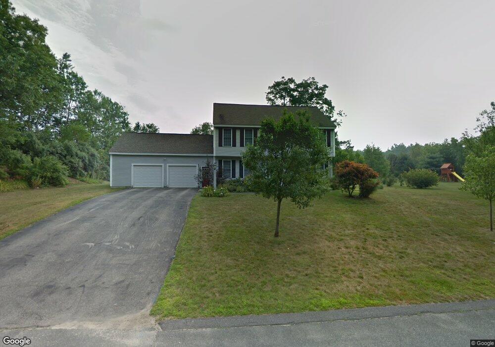
11 Rivington Dr West Boylston, MA 01583
Estimated Value: $724,604 - $918,000
3
Beds
3
Baths
2,428
Sq Ft
$324/Sq Ft
Est. Value
About This Home
This home is located at 11 Rivington Dr, West Boylston, MA 01583 and is currently estimated at $786,651, approximately $323 per square foot. 11 Rivington Dr is a home located in Worcester County with nearby schools including Major Edwards Elementary School and West Boylston Junior/Senior High School.
Ownership History
Date
Name
Owned For
Owner Type
Purchase Details
Closed on
Jun 5, 1997
Sold by
Ashwood Dev Companies
Bought by
Dahlberg Seth T and Chaffee Anne C
Current Estimated Value
Home Financials for this Owner
Home Financials are based on the most recent Mortgage that was taken out on this home.
Original Mortgage
$204,450
Interest Rate
7.98%
Mortgage Type
Purchase Money Mortgage
Create a Home Valuation Report for This Property
The Home Valuation Report is an in-depth analysis detailing your home's value as well as a comparison with similar homes in the area
Home Values in the Area
Average Home Value in this Area
Purchase History
| Date | Buyer | Sale Price | Title Company |
|---|---|---|---|
| Dahlberg Seth T | $243,142 | -- |
Source: Public Records
Mortgage History
| Date | Status | Borrower | Loan Amount |
|---|---|---|---|
| Open | Dahlberg Seth T | $188,000 | |
| Closed | Dahlberg Seth T | $202,850 | |
| Closed | Dahlberg Seth T | $204,450 |
Source: Public Records
Tax History Compared to Growth
Tax History
| Year | Tax Paid | Tax Assessment Tax Assessment Total Assessment is a certain percentage of the fair market value that is determined by local assessors to be the total taxable value of land and additions on the property. | Land | Improvement |
|---|---|---|---|---|
| 2025 | $95 | $684,300 | $123,600 | $560,700 |
| 2024 | $9,068 | $613,500 | $127,100 | $486,400 |
| 2023 | $8,709 | $559,000 | $125,500 | $433,500 |
| 2022 | $8,326 | $470,900 | $128,900 | $342,000 |
| 2021 | $8,242 | $446,500 | $118,300 | $328,200 |
| 2020 | $7,753 | $417,300 | $121,500 | $295,800 |
| 2019 | $4,460 | $403,200 | $121,500 | $281,700 |
| 2018 | $4,838 | $386,100 | $121,500 | $264,600 |
| 2017 | $7,153 | $380,500 | $121,500 | $259,000 |
| 2016 | $7,004 | $379,600 | $112,800 | $266,800 |
| 2015 | $6,995 | $381,400 | $111,800 | $269,600 |
Source: Public Records
Map
Nearby Homes
- 287 Laurel St
- 16 N Main St
- 26 Townsend Dr
- 0 North St
- 20 Winthrop St
- Lot 1 Manning St
- 136 Sterling St Unit A3
- 156 Prospect St
- 0 Boutelle Rd
- 61 Boutelle Rd
- 2 Lakeview Ave
- 18 Laurel Ave
- 223 Worcester Rd
- 152 Worcester St Unit 8
- 21 Myrtle Ave
- 54 Maple St
- 62 Maple St
- 4 Jewett Rd Unit B
- 4 Jewett Rd Unit A
- 47 Preservation Ln
- 31 Rivington Dr
- 23 Rivington Dr
- 15 Rivington Dr
- 27 Rivington Dr
- 19 Rivington Dr
- 12 Rivington Dr
- 12 Rivington Dr Unit a
- 52 Rivington Dr
- 56 Rivington Dr
- 3 Rivington Dr
- 48 Rivington Dr
- 68 Rivington Dr
- 64 Rivington Dr
- 60 Rivington Dr
- 127 Laurel St
- 135 Laurel St
- 139 Laurel St
- L18 Rivington Dr
- 125 Laurel St
- 121 Laurel St