Estimated Value: $844,000 - $1,049,000
--
Bed
--
Bath
2,553
Sq Ft
$366/Sq Ft
Est. Value
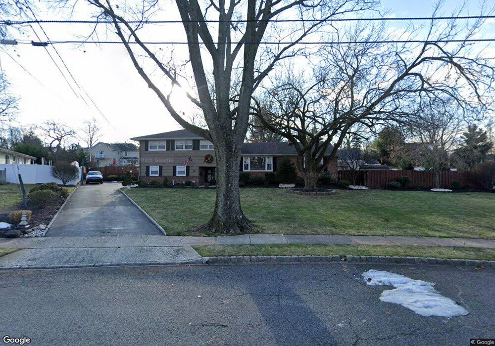
About This Home
This home is located at 11 Rutgers Rd, Clark, NJ 07066 and is currently estimated at $935,637, approximately $366 per square foot. 11 Rutgers Rd is a home located in Union County with nearby schools including Frank K. Hehnly Elementary School, Carl H. Kumpf Middle School, and Arthur L. Johnson High School.
Ownership History
Date
Name
Owned For
Owner Type
Purchase Details
Closed on
May 24, 2000
Sold by
Manna Mauro and Manna Betty Rose
Bought by
Rebosio Guido D and Rebosio Lisa M
Current Estimated Value
Home Financials for this Owner
Home Financials are based on the most recent Mortgage that was taken out on this home.
Original Mortgage
$38,900
Interest Rate
8.12%
Mortgage Type
Stand Alone Second
Purchase Details
Closed on
Sep 27, 1995
Sold by
Altman Anita W
Bought by
Manna Mauro and Manna Betty Rose
Create a Home Valuation Report for This Property
The Home Valuation Report is an in-depth analysis detailing your home's value as well as a comparison with similar homes in the area
Home Values in the Area
Average Home Value in this Area
Purchase History
| Date | Buyer | Sale Price | Title Company |
|---|---|---|---|
| Rebosio Guido D | $324,000 | Old Republic Title | |
| Manna Mauro | $200,000 | -- |
Source: Public Records
Mortgage History
| Date | Status | Borrower | Loan Amount |
|---|---|---|---|
| Closed | Rebosio Guido D | $38,900 | |
| Open | Rebosio Guido D | $252,700 |
Source: Public Records
Tax History Compared to Growth
Tax History
| Year | Tax Paid | Tax Assessment Tax Assessment Total Assessment is a certain percentage of the fair market value that is determined by local assessors to be the total taxable value of land and additions on the property. | Land | Improvement |
|---|---|---|---|---|
| 2025 | $15,246 | $688,600 | $242,500 | $446,100 |
| 2024 | $15,018 | $688,600 | $242,500 | $446,100 |
| 2023 | $15,018 | $688,600 | $242,500 | $446,100 |
| 2022 | $14,585 | $688,600 | $242,500 | $446,100 |
| 2021 | $14,500 | $163,100 | $52,500 | $110,600 |
| 2020 | $14,263 | $163,100 | $52,500 | $110,600 |
| 2019 | $14,120 | $163,100 | $52,500 | $110,600 |
| 2018 | $13,950 | $163,100 | $52,500 | $110,600 |
| 2017 | $13,727 | $163,100 | $52,500 | $110,600 |
| 2016 | $13,221 | $163,100 | $52,500 | $110,600 |
| 2015 | $13,087 | $163,100 | $52,500 | $110,600 |
| 2014 | $12,812 | $163,100 | $52,500 | $110,600 |
Source: Public Records
Map
Nearby Homes
- 38 Meadow Rd
- 148 Stonehenge Terrace
- 107 Meadow Rd
- 52 Brookside Terrace
- 1033 Cellar Ave Unit 1033
- 67 Brookside Terrace
- 37 Wareham Ct
- 8 Maddaket
- 131 Morningside Rd
- 86 Normandy Rd
- 44 Maddaket Ct
- 44 Maddaket Unit 44
- 23 Burnham Ct
- 675 Raritan Rd
- 675 Raritan Rd Unit 33
- 24 Woodland Rd
- 54 Morningside Rd
- 70 Lancaster Rd
- 2004 Winding Brook Way
- 20 Hilltop Ave
- 5 Rutgers Rd
- 21 Rutgers Rd
- 440 Oak Ridge Rd
- 432 Oak Ridge Rd
- 448 Oak Ridge Rd
- 1115 Lake Ave
- 424 Oak Ridge Rd
- 29 Rutgers Rd
- 1088 Lake Ave
- 416 Oak Ridge Rd
- 458 Oak Ridge Rd
- 1108 Lake Ave
- 1119 Lake Ave
- 37 Rutgers Rd
- 1076 Lake Ave
- 63 Lance Dr
- 439 Oak Ridge Rd
- 408 Oak Ridge Rd
- 1116 Lake Ave
- 8 Locust Grove Dr