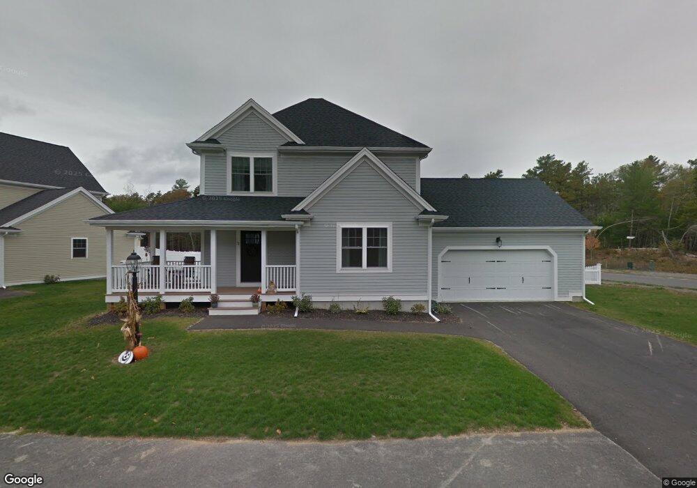
11 Sapling Cir Kingston, MA 02364
Estimated Value: $675,000 - $782,000
3
Beds
3
Baths
1,784
Sq Ft
$415/Sq Ft
Est. Value
About This Home
This home is located at 11 Sapling Cir, Kingston, MA 02364 and is currently estimated at $740,143, approximately $414 per square foot. 11 Sapling Cir is a home with nearby schools including Kingston Elementary School, Silver Lake Regional High School, and Kingston Intermediate School.
Ownership History
Date
Name
Owned For
Owner Type
Purchase Details
Closed on
Jul 6, 2016
Sold by
William J Chase Ret
Bought by
Farrell Edward and Farrell Nicole
Current Estimated Value
Home Financials for this Owner
Home Financials are based on the most recent Mortgage that was taken out on this home.
Original Mortgage
$379,905
Outstanding Balance
$303,864
Interest Rate
3.64%
Mortgage Type
New Conventional
Estimated Equity
$436,279
Create a Home Valuation Report for This Property
The Home Valuation Report is an in-depth analysis detailing your home's value as well as a comparison with similar homes in the area
Home Values in the Area
Average Home Value in this Area
Purchase History
| Date | Buyer | Sale Price | Title Company |
|---|---|---|---|
| Farrell Edward | $409,000 | -- |
Source: Public Records
Mortgage History
| Date | Status | Borrower | Loan Amount |
|---|---|---|---|
| Open | Farrell Edward | $379,905 |
Source: Public Records
Tax History
| Year | Tax Paid | Tax Assessment Tax Assessment Total Assessment is a certain percentage of the fair market value that is determined by local assessors to be the total taxable value of land and additions on the property. | Land | Improvement |
|---|---|---|---|---|
| 2025 | $8,287 | $638,900 | $199,900 | $439,000 |
| 2024 | $7,613 | $599,000 | $199,900 | $399,100 |
| 2023 | $7,305 | $546,800 | $199,900 | $346,900 |
| 2022 | $7,058 | $484,100 | $177,200 | $306,900 |
| 2021 | $6,561 | $408,000 | $163,700 | $244,300 |
| 2020 | $7,507 | $461,100 | $163,700 | $297,400 |
| 2019 | $6,716 | $408,000 | $163,700 | $244,300 |
| 2018 | $6,225 | $378,400 | $163,700 | $214,700 |
| 2017 | $4,668 | $282,900 | $158,900 | $124,000 |
| 2016 | $548 | $31,100 | $31,100 | $0 |
| 2015 | $527 | $31,100 | $31,100 | $0 |
| 2014 | $519 | $31,100 | $31,100 | $0 |
Source: Public Records
Map
Nearby Homes
- 42 Christmas Tree Ln
- 0 Spring St
- 61 Esta Rd
- 103 Esta Rd
- 6 Twin Pines Ln Unit 6
- 14 Mariner's Way Unit 14
- 44 Mariner's Way Unit 44
- 241 Carver Rd Unit 7
- 51 Mariner's Way Unit 51
- 1 Mariner's Way Unit 309
- 1 Mariner's Way Unit 204
- 2 Mariner's Way Unit 306
- 62 Mariners Way Unit 305
- 62 Mariners Way Unit 301
- 44 Meeting House Rd
- 12 Meeting House Rd
- 19 Roosevelt Rd
- 6 Coachman Terrace
- 19 Coachman Terrace
- 144 Industrial Park Rd
- 15 Sapling Cir
- 14 Sapling Cir
- 10 Sapling Cir
- 54 Christmas Tree Ln
- 43 Christmas Tree Ln
- 19 Sapling Cir
- 58 Christmas Tree Ln
- 38 Christmas Tree Ln
- 51 Christmas Tree Ln
- 22 Sapling Cir
- 34 Christmas Tree Ln
- 26 Sapling Cir
- 39 Christmas Tree Ln
- 59 Christmas Tree Ln
- 30 Christmas Tree Ln
- 63 Christmas Tree Ln
- 14 Christmas Tree Ln
- 22 Christmas Tree Ln
- 26 Christmas Tree Ln
- 66 Christmas Tree Ln
Your Personal Tour Guide
Ask me questions while you tour the home.