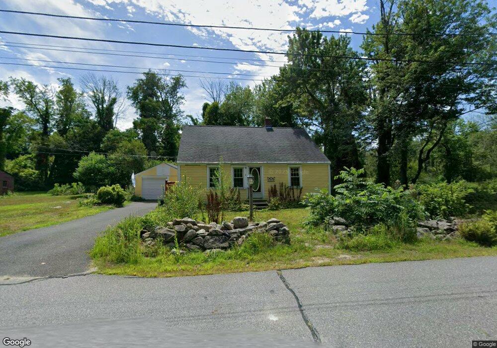
11 Spring St Petersham, MA 01366
Estimated Value: $281,989 - $333,000
2
Beds
1
Bath
896
Sq Ft
$345/Sq Ft
Est. Value
About This Home
This home is located at 11 Spring St, Petersham, MA 01366 and is currently estimated at $309,247, approximately $345 per square foot. 11 Spring St is a home located in Worcester County with nearby schools including Petersham Center, Ralph C Mahar Regional School, and Petersham Montessori School.
Ownership History
Date
Name
Owned For
Owner Type
Purchase Details
Closed on
Oct 3, 2016
Sold by
Connolly May L
Bought by
May Connolly 2016 Lt
Current Estimated Value
Purchase Details
Closed on
Sep 4, 2009
Sold by
Frost Doreen
Bought by
Connolly Allan and Connolly May L
Home Financials for this Owner
Home Financials are based on the most recent Mortgage that was taken out on this home.
Original Mortgage
$121,600
Interest Rate
5.21%
Mortgage Type
Purchase Money Mortgage
Purchase Details
Closed on
Sep 8, 2000
Sold by
Piermarine Paul P and Piermarine Muriel
Bought by
Frost Doreen
Home Financials for this Owner
Home Financials are based on the most recent Mortgage that was taken out on this home.
Original Mortgage
$62,000
Interest Rate
8.1%
Mortgage Type
Purchase Money Mortgage
Purchase Details
Closed on
Dec 23, 1996
Sold by
Albertine Glenede F
Bought by
Piermarini Paul P and Piermarini Muriel
Create a Home Valuation Report for This Property
The Home Valuation Report is an in-depth analysis detailing your home's value as well as a comparison with similar homes in the area
Home Values in the Area
Average Home Value in this Area
Purchase History
| Date | Buyer | Sale Price | Title Company |
|---|---|---|---|
| May Connolly 2016 Lt | -- | -- | |
| Connolly Allan | $152,000 | -- | |
| Frost Doreen | $87,000 | -- | |
| Piermarini Paul P | $60,000 | -- |
Source: Public Records
Mortgage History
| Date | Status | Borrower | Loan Amount |
|---|---|---|---|
| Previous Owner | Connolly Allan | $121,600 | |
| Previous Owner | Piermarini Paul P | $62,000 | |
| Previous Owner | Piermarini Paul P | $16,500 | |
| Closed | Piermarini Paul P | $10,000 |
Source: Public Records
Tax History
| Year | Tax Paid | Tax Assessment Tax Assessment Total Assessment is a certain percentage of the fair market value that is determined by local assessors to be the total taxable value of land and additions on the property. | Land | Improvement |
|---|---|---|---|---|
| 2025 | $3,398 | $234,500 | $45,800 | $188,700 |
| 2024 | $2,893 | $202,300 | $45,800 | $156,500 |
| 2023 | $2,514 | $159,200 | $43,600 | $115,600 |
| 2022 | $2,156 | $159,200 | $43,600 | $115,600 |
| 2021 | $2,344 | $153,100 | $39,600 | $113,500 |
| 2020 | $2,421 | $139,400 | $34,300 | $105,100 |
| 2019 | $2,236 | $132,100 | $30,100 | $102,000 |
| 2018 | $2,143 | $130,900 | $28,900 | $102,000 |
| 2017 | $2,135 | $131,900 | $30,900 | $101,000 |
| 2016 | $2,166 | $131,900 | $30,900 | $101,000 |
| 2015 | $2,222 | $130,800 | $30,900 | $99,900 |
| 2014 | $2,084 | $130,800 | $30,900 | $99,900 |
Source: Public Records
Map
Nearby Homes
- 17 S Main St
- 0 Popple Camp Rd Unit 73432026
- 22 Old Hardwick Rd
- 47 Harty Dr
- 32 Edward Ln
- 21 Varney Ln
- 31 Edward Ln
- 37 Gauthier Rd
- 1082 Old Dana Rd
- 420 Queen Lake Rd
- 180 Petersham Rd
- 1000 West St
- 225 Queen Lake Rd
- 14 Jackson Ln
- 40 Jackson Ln
- 156 Vaughn Rd
- 0 Riceville Rd Unit 73429842
- 321 Doe Valley Rd
- 0 Miles Rd
- Lot-2 Petersham Rd
Your Personal Tour Guide
Ask me questions while you tour the home.