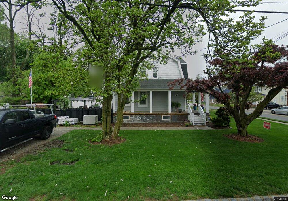
11 Stanley Rd Little Falls, NJ 07424
Estimated Value: $497,735 - $615,000
--
Bed
--
Bath
1,474
Sq Ft
$372/Sq Ft
Est. Value
About This Home
This home is located at 11 Stanley Rd, Little Falls, NJ 07424 and is currently estimated at $548,434, approximately $372 per square foot. 11 Stanley Rd is a home located in Passaic County with nearby schools including Little Falls Township Public School No. 2, Little Falls School No. 3, and Little Falls School No. 1.
Ownership History
Date
Name
Owned For
Owner Type
Purchase Details
Closed on
Feb 28, 2005
Sold by
Deluca Ann
Bought by
Carrion John and Carrion Diane
Current Estimated Value
Home Financials for this Owner
Home Financials are based on the most recent Mortgage that was taken out on this home.
Original Mortgage
$331,075
Outstanding Balance
$166,510
Interest Rate
5.49%
Mortgage Type
Adjustable Rate Mortgage/ARM
Estimated Equity
$381,924
Purchase Details
Closed on
Jun 30, 2003
Sold by
Jtf Realty Llc
Bought by
Deluca Anm Marie
Home Financials for this Owner
Home Financials are based on the most recent Mortgage that was taken out on this home.
Original Mortgage
$201,000
Interest Rate
5.45%
Purchase Details
Closed on
Jul 29, 2002
Sold by
Holowack William
Bought by
Jtf Realty Llc
Create a Home Valuation Report for This Property
The Home Valuation Report is an in-depth analysis detailing your home's value as well as a comparison with similar homes in the area
Home Values in the Area
Average Home Value in this Area
Purchase History
| Date | Buyer | Sale Price | Title Company |
|---|---|---|---|
| Carrion John | $348,500 | -- | |
| Deluca Anm Marie | $268,000 | -- | |
| Jtf Realty Llc | $290,000 | -- |
Source: Public Records
Mortgage History
| Date | Status | Borrower | Loan Amount |
|---|---|---|---|
| Open | Carrion John | $331,075 | |
| Previous Owner | Deluca Anm Marie | $201,000 |
Source: Public Records
Tax History Compared to Growth
Tax History
| Year | Tax Paid | Tax Assessment Tax Assessment Total Assessment is a certain percentage of the fair market value that is determined by local assessors to be the total taxable value of land and additions on the property. | Land | Improvement |
|---|---|---|---|---|
| 2025 | $8,213 | $246,500 | $100,300 | $146,200 |
| 2024 | $8,090 | $246,500 | $100,300 | $146,200 |
| 2022 | $8,100 | $246,500 | $100,300 | $146,200 |
| 2021 | $7,918 | $246,500 | $100,300 | $146,200 |
| 2020 | $7,846 | $246,500 | $100,300 | $146,200 |
| 2019 | $7,841 | $246,500 | $100,300 | $146,200 |
| 2018 | $7,789 | $246,500 | $100,300 | $146,200 |
| 2017 | $7,797 | $246,500 | $100,300 | $146,200 |
| 2016 | $7,693 | $246,500 | $100,300 | $146,200 |
| 2015 | $7,582 | $246,500 | $100,300 | $146,200 |
| 2014 | $7,380 | $246,500 | $100,300 | $146,200 |
Source: Public Records
Map
Nearby Homes
- 240 Woodcliff Ave
- 250 Woodcliff Ave
- 0 Amity St
- 10 Park Place
- 35 Hughes Place
- 19 Haines Place
- 16 Hughes Place
- 60 Woodcliff Ave
- 57 Riverlawn Dr
- 10 Harvest Way
- 1 Stepping Ridge
- 42 Riverlawn Dr
- 30 Andrea Dr
- 18 Fairview Dr
- 12 Bergen Dr
- 58 Harvest Way
- 160 Grandview Ave
- 58 Zeliff Ave
- 170 Donato Dr
- 96 Montclair Ave