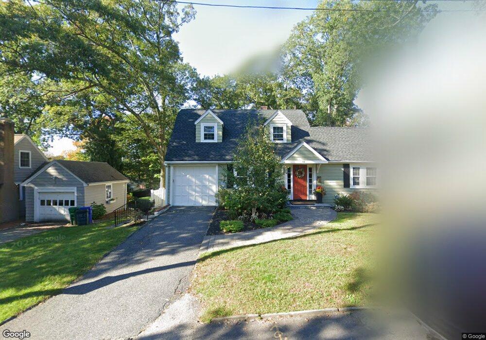
11 Tamarac Rd Newton Upper Falls, MA 02464
Newton Upper Falls NeighborhoodEstimated Value: $1,058,000 - $1,332,933
3
Beds
2
Baths
1,491
Sq Ft
$793/Sq Ft
Est. Value
About This Home
This home is located at 11 Tamarac Rd, Newton Upper Falls, MA 02464 and is currently estimated at $1,182,483, approximately $793 per square foot. 11 Tamarac Rd is a home located in Middlesex County with nearby schools including Zervas Elementary School, Angier Elementary School, and Charles E Brown Middle School.
Ownership History
Date
Name
Owned For
Owner Type
Purchase Details
Closed on
Oct 19, 2006
Sold by
Dye Paul A and Moore Therese J
Bought by
Adyanthaya Amy L and Adyanthaya Anil J
Current Estimated Value
Purchase Details
Closed on
Apr 16, 1999
Sold by
Kincaid Rosemary F
Bought by
Dye Paul A and Moore Therese J
Create a Home Valuation Report for This Property
The Home Valuation Report is an in-depth analysis detailing your home's value as well as a comparison with similar homes in the area
Home Values in the Area
Average Home Value in this Area
Purchase History
| Date | Buyer | Sale Price | Title Company |
|---|---|---|---|
| Adyanthaya Amy L | $514,000 | -- | |
| Dye Paul A | $300,000 | -- |
Source: Public Records
Mortgage History
| Date | Status | Borrower | Loan Amount |
|---|---|---|---|
| Open | Dye Paul A | $38,300 | |
| Open | Dye Paul A | $391,000 | |
| Closed | Dye Paul A | $396,500 |
Source: Public Records
Tax History Compared to Growth
Tax History
| Year | Tax Paid | Tax Assessment Tax Assessment Total Assessment is a certain percentage of the fair market value that is determined by local assessors to be the total taxable value of land and additions on the property. | Land | Improvement |
|---|---|---|---|---|
| 2025 | $9,058 | $924,300 | $862,000 | $62,300 |
| 2024 | $8,759 | $897,400 | $836,900 | $60,500 |
| 2023 | $8,107 | $796,400 | $636,100 | $160,300 |
| 2022 | $7,757 | $737,400 | $589,000 | $148,400 |
| 2021 | $7,486 | $695,700 | $555,700 | $140,000 |
| 2020 | $6,544 | $695,700 | $555,700 | $140,000 |
| 2019 | $7,058 | $675,400 | $539,500 | $135,900 |
| 2018 | $6,698 | $619,000 | $485,800 | $133,200 |
| 2017 | $6,494 | $584,000 | $458,300 | $125,700 |
| 2016 | $6,211 | $545,800 | $428,300 | $117,500 |
| 2015 | $5,922 | $510,100 | $400,300 | $109,800 |
Source: Public Records
Map
Nearby Homes
- 103 Thurston Rd
- 66 Rockland Place
- 102 Thurston Rd Unit 100
- 17 Circuit Ave Unit 2
- 120 Stanley Rd
- 131 Oliver Rd
- 992 Chestnut St
- 51 Pettee St Unit 11
- 1077 Boylston St
- 989 Chestnut St Unit 8
- 1003 Chestnut St
- 873 Chestnut St
- 200 Lincoln St
- 12 Shawmut Park
- 45 River Ave Unit 45
- 20 Pennsylvania Ave
- 20 Pennsylvania Ave Unit 20
- 18-20 Pennsylvania Ave Unit 18
- 27 Hamilton Place
- 27 Indiana Terrace Unit 29
- 29 White Pine Rd
- 17 Tamarac Rd
- 24 Rockland Place
- 23 White Pine Rd
- 12 Tamarac Rd
- 18 Tamarac Rd
- 18 Rockland Place
- 39 White Pine Rd
- 31 Rockland Place
- 19 White Pine Rd
- 46 Rockland Place
- 39 Rockland Place
- 46 Rockland Place
- 16 White Pine Rd
- 12 Rockland Place
- 34 White Pine Rd
- 19 Rockland Place
- 47 White Pine Rd
- 40 White Pine Rd
- 11 Rockland Place